List Entry Summary
This monument is scheduled under the Ancient Monuments and Archaeological Areas Act 1979 as amended as it appears to the Secretary of State to be of national importance. This entry is a copy, the original is held by the Department for Culture, Media and Sport.
Name: Roman villa 300m south of Long Shaw
List Entry Number: 1008896
Location
The monument may lie within the boundary of more than one authority.
County: Essex
District: Epping Forest
District Type: District Authority
Parish: Loughton
National Park: Not applicable to this List entry.
Grade: Not applicable to this List entry.
Date first scheduled: 13-Dec-1977
Date of most recent amendment: 20-Aug-1994
Legacy System Information
The contents of this record have been generated from a legacy data system.
Legacy System: RSM
UID: 24863
Asset Groupings
This List entry does not comprise part of an Asset Grouping. Asset Groupings are not part of the official record but are added later for information.
List Entry Description
Summary of Monument
Legacy Record - This information may be included in the List Entry Details.
Reasons for Designation
Romano-British villas were extensive rural estates at the focus of which were
groups of domestic, agricultural and occasionally industrial buildings. The
term "villa" is now commonly used to describe either the estate or the
buildings themselves. The buildings usually include a well-appointed dwelling
house, the design of which varies considerably according to the needs, taste
and prosperity of the occupier. Most of the houses were partly or wholly
stone-built, many with a timber-framed superstructure on masonry footings.
Roofs were generally tiled and the house could feature tiled or mosaic floors,
underfloor heating, wall plaster, glazed windows and cellars. Many had
integral or separate suites of heated baths. The house was usually accompanied
by a range of buildings providing accommodation for farm labourers, workshops
and storage for agricultural produce. These were arranged around or alongside
a courtyard and were surrounded by a complex of paddocks, pens, yards and
features such as vegetable plots, granaries, threshing floors, wells and
hearths, all approached by tracks leading from the surrounding fields. Villa
buildings were constructed throughout the period of Roman occupation, from the
first to the fourth centuries AD. They are usually complex structures occupied
over several hundred years and continually remodelled to fit changing
circumstances. They could serve a wide variety of uses alongside agricultural
activities, including administrative, recreational and craft functions, and
this is reflected in the considerable diversity in their plan. The least
elaborate villas served as simple farmhouses whilst, for the most complex, the
term "palace" is not inappropriate. Villa owners tended to be drawn from a
limited elite section of Romano-British society. Although some villas belonged
to immigrant Roman officials or entrepreneurs, the majority seem to have been
in the hands of wealthy natives with a more-or-less Romanised lifestyle, and
some were built directly on the sites of Iron Age farmsteads. Roman villa
buildings are widespread, with between 400 and 1000 examples recorded
nationally. The majority of these are classified as `minor' villas to
distinguish them from `major' villas. The latter were a very small group of
extremely substantial and opulent villas built by the very wealthiest members
of Romano-British society. Minor villas are found throughout lowland Britain
and occasionally beyond. Roman villas provide a valuable index of the rate,
extent and degree to which native British society became Romanised, as well as
indicating the sources of inspiration behind changes of taste and custom. In
addition, they serve to illustrate the agrarian and economic history of the
Roman province, allowing comparisons over wide areas both within and beyond
Britain. As a very diverse and often long-lived type of monument, a
significant proportion of the known population are identified as nationally
important.
As confirmed by partial excavation, the Roman villa south of Long Shaw
survives well below the ploughsoil. Only a small part of the site has been
excavated leaving the greater part of the buried remains of the buildings and
associated deposits and structures undisturbed. These deposits will contain
information about the construction and layout of the villa and its associated
buildings, whilst the associated artefactual information, and any
environmental deposits which may survive at the base of the sequence, will add
to our understanding of the life-style and economy of the inhabitants and of
the landscape in which they lived. The evidence from the site is valuable for
understanding Roman rural settlement in this part of south east England.
History
Legacy Record - This information may be included in the List Entry Details.
Details
The monument includes a Roman villa situated just below the crest of a rise in
the chalky boulder clay overlying the London Clay. The gentle south east
facing slope runs down towards the River Roding 1km away.
The location of the building has been identified from a concentration of
building and occupation material recovered from fieldwalking, including Roman
roof tile, pottery and quern stone fragments. The main concentration covers an
area of c.120m north west to south east by 70m north east to south west.
Foundations and floor layers are believed to survive in the north west part of
this area.
The site was originally noted in 1976 during the excavation of a crashed
plane. A surface collection of material was then undertaken. In addition to
Roman material, some Iron Age pottery and Mesolithic flint tools were also
recovered.
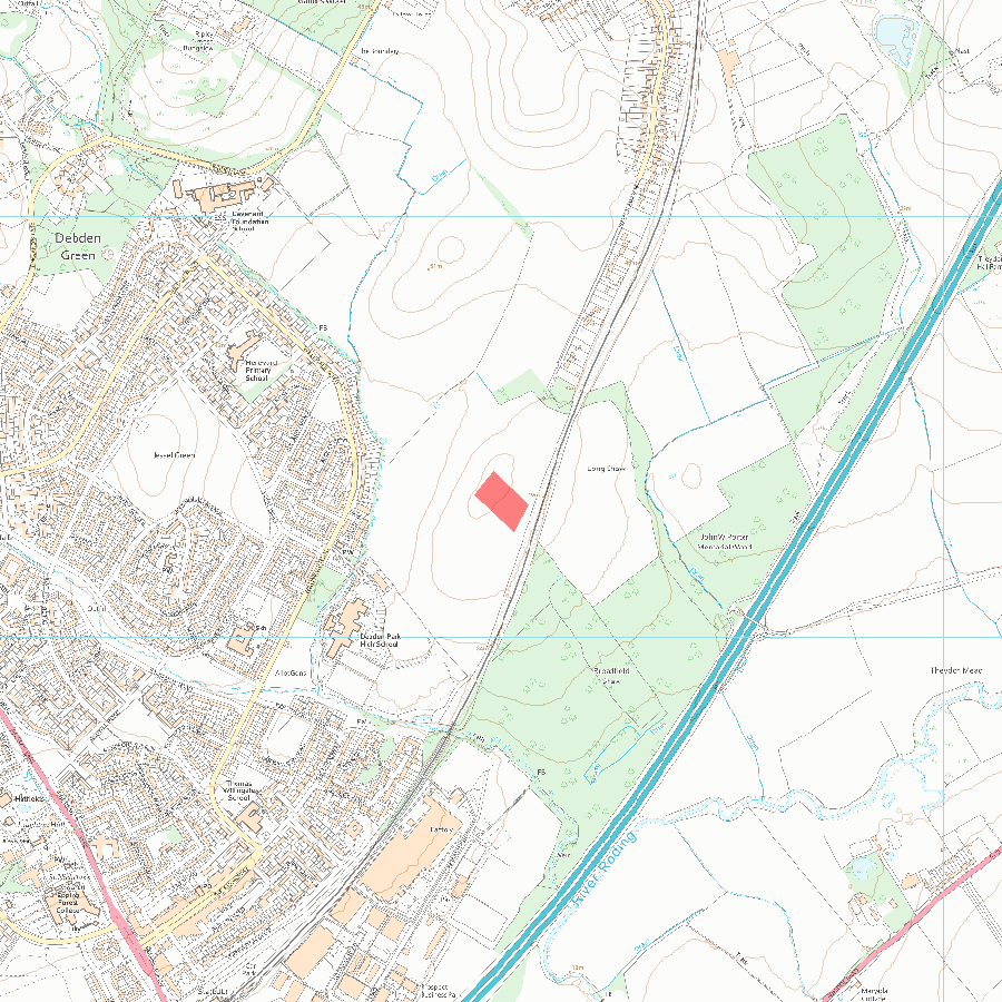
MAP EXTRACT
The site of the monument is shown on the attached map extract.
Selected Sources
OtherEssex Sites and Monuments Record 139, (1985)
Map
National Grid Reference: TQ 44948 97329
The below map is for quick reference purposes only and may not be to scale. For a copy of the full scale map, please see the attached PDF - 1008896.pdf - Please be aware that it may take a few minutes for the download to complete.
© Crown Copyright and database right 2018. All rights reserved. Ordnance Survey Licence number 100024900.
© British Crown and SeaZone Solutions Limited 2018. All rights reserved. Licence number 102006.006.
This copy shows the entry on 12-Jul-2025 at 03:13:46.


