See important
guidance on the use of this record.
If you have any comments or new information about this record, please email us.
| HER Number: | MDV10474 |
|---|
| Name: | Earthwork Mound on Woodbury Common |
|---|
Summary
An earthwork mound interpreted as the probable result of 18th – 19th century landscaping works is visible as an earthwork mound and ditch on aerial photographs of 1946 onwards and on visualisations derived from lidar data captured in 2016.
Location
| Grid Reference: | SY 034 864 |
|---|
| Map Sheet: | SY08NW |
|---|
| Admin Area | Devon |
|---|
| Civil Parish | Woodbury |
|---|
| District | East Devon |
|---|
| Ecclesiastical Parish | WOODBURY |
|---|
Protected Status
Other References/Statuses
- National Monuments Record: 448602
- Old DCC SMR Ref: SY08NW/6
- Old SAM County Ref: 60G
- Old SAM Ref: 29651
Monument Type(s) and Dates
- BARROW (Bronze Age - 2200 BC to 701 BC (Between))
- MOUND (XVIII to XIX - 1701 AD to 1900 AD (Between))
Full description
Unknown, MIGRATED RECORD - MONUMENT PROTECTION PROGRAMME DATA (Migrated Record). SDV331.
Vis=2/12/1997 (salvatore) bowl barrow, 2.5m high, 14m diam, surrounded by quarry ditch 1.9m wide, 0.4m deep. This barrow and sy08nw/5 are surrounded at a further distance by a bank and outer ditch. These are additional features of perhaps more recent date, as part of landscaping thought by southwell to date to late c18-early c19. Tyler suggests that they may be napoleonic defences, although this seems unlikely and probert states that the barrows are shown on a plan of 1801 whilst troops stationed in the area during the invasion threat did not arrive until after that date (mpp).
Untitled Source (Migrated Record). SDV1004.
Vis=27/4/1972 and 21/4/1982 (grinsell) all covered in trees and undergrowth. Looks recent by reason of steep profile. Diameter is 14m and height 1.8m.(grinsell).
SOUTHWELL, Untitled Source (Migrated Record). SDV104783.
Unlikely to be prehistoric. Possibly connected with the military activity on the common during the napoleonic war, or part of the 18/19th century landscaping of lord rolle (southwell).
Ancient Monuments, Untitled Source (Report - Survey). SDV104904.
Vis=-/6/1923(ancient monuments) tumuli on woodbury common. From four firs along the yettington road eastwards, two tumuli are marked f and g on the 6" os map about 152m before entering the boundridge plantation. Barrow g is surrounded by earth walls of modern construction, the highway runs between them.
RCHME, Untitled Source (Report - Survey). SDV104909.
Vis=5/9/1990 (rchme) centred sy03608642. Four probable landscaping mounds, arranged in 2 pairs, flank the woodbury-yettington road on woodbury common.
SEE 5,IAM, Untitled Source (Migrated Record). SDV104910.
All mounds are steep sided with gently rounded tops. Their diam vary between 9.3 and 10.5 with heights between 1.8m and 2.6m. The 2 e mounds at sy03448646 and sy03458642 are enclosed by circular earth and stone banks, 1.3m wide and 0.7m high which lie close to the mound. The w mounds at sy03758636 and sy03738633 are unenclosed, lying on the woodbury/bicton parish boundary. Mature conifers cover the e mounds while the 2 to the w are currently unplanted. The two mounds scheduled 60 j and l do not exist. It seems unlikely that they were ever present, 2 clumps of scots pines were apparently scheduled on circumstantial evidence without being investigated (see 5,iam).
NMR, CITING PROBERT, Untitled Source (Migrated Record). SDV104911.
Although one of the mounds is alleged to have produced evidence of a cremation and associated finds ( see brighouse) there can be little doubt that in their present form they are the result of landscaping activity initiated by lord rolle of bicton in the late 18c or 19c (nmr, citing probert).
Untitled Source (Migrated Record). SDV104914.
Southwell, c. /woodbury common/unpublished undergraduate dissertation/ exeter university/(1981).
Untitled Source (Migrated Record). SDV104915.
Vancouver, c. /general view of the agriculture of the county of devon/ (1808)293.
Untitled Source (Migrated Record). SDV104916.
Des=robinson, r. /list of fmw visits(19/1/1983)in smr.
Untitled Source (Migrated Record). SDV104917.
Grinsell, l. V. /pdas/41(1985)45.
Untitled Source (Migrated Record). SDV104918.
Des=mpp/144407.
Untitled Source (Migrated Record). SDV104919.
Nmr=sy08nw8.
Untitled Source (Migrated Record). SDV104920.
Tyler, f. C. /dcnq/16(1931)340/mounds on woodbury common.
Untitled Source (Migrated Record). SDV104921.
Des=probert, s. A. J. /(1990)/rchme field investigation.
Ordnance Survey, 1880-1899, First Edition Ordnance 25 inch map (Cartographic). SDV336179.
The earthwork mound is depicted.
Ordnance Survey, 1880-1899, First Edition Ordnance 25 inch map (Cartographic). SDV336179.
Royal Air Force, 1946, RAF/106G/UK/1412, RAF/106G/UK/1412 3172-73 13-APR-1946 (Aerial Photograph). SDV352504.
The earthwork mound is partly visible.
Griffiths, D., 1983, ?Quay (Worksheet). SDV13596.
Vis=19/1/1982 (griffiths) barrow is over 2m high. Thickly covered with firs.
Exeter Archaeology, 2003, East Devon Heathlands Archaeological Survey, Site No. 7 (Archive - Survey). SDV358490.
Exeter Archaeology, 2003, East Devon Heathlands Archaeological Survey, Site No. 7 (Report - Survey). SDV359019.
Exeter Archaeology, 2003, East Devon Heathlands Archaeological Survey, Part 2: Gazetteer, 2, Site No. 7 (Report - Survey). SDV101648.
Mound, one of a pair flanking either side of the road. May represent prehistoric barrow, 18th century landscaping mound, or both (i.e. barrow remodelled). Mound described by SMR as 14 metres diameter by 2.5 metres high with surrounding ditch, and further outer bank and ditch. Mound and ditch visible but area covered in dense bracken.
Exeter Archaeology, 2003-2004, East Devon Area of Outstanding Natural Beauty Archaeological Survey, Site No. 2663 (Archive - Survey). SDV351568.
Barrow. Scheduled Monument.
See description in East Devon Heathlands Archaeological Survey Part 2: Gazetteer, 2, Site No. 7 - SDV101648.
Exeter Archaeology, 2007, East Devon Access Land Archaeological Survey 2007, 16-17, Site No. 2663 (Archive - Survey). SDV351571.
Mound, one of a pair flanking either side of the road. May represent a prehistoric barrow, 18th century landscaping mound, or both. Mound and ditch are just visible through bracken.
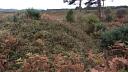
The mound appears to be visible from the road as a higher area of vegetation, but it was not possible to reach it due to vegetation density. Vegetation must preclude most public access and there are some beaten paths but these are likely to be related to military training activity.
Protection during vegetation clearance. Possible interpretation as one of a group of mounds.
Exeter Archaeology, 2008, East Devon Access Land Archaeological Survey 2007, 2, Site No. 2663 (Report - Survey). SDV351570.
A number of the larger mounds are believed to represent prehistoric barrows that were remodelled in the 18th century to form landscape features.
Next Perspectives, 2010, Aerial Photography for Great Britain, Next Perspectives PGA Imagery SY0386 22-MAY-2010 (Aerial Photograph). SDV356259.
The earthwork mound is visible.
Ordnance Survey, 2010, MasterMap (Cartographic). SDV344030.
English Heritage, 2011, Heritage at Risk Register 2011: South West, 95 (Report - non-specific). SDV355280.
Generally satisfactory but with significant localised problems. Declining. Principal vulnerability scrub/tree growth.
Hegarty, C. + Knight, S. + Sims, R., 2014-2015, East and Mid Devon River Catchments National Mapping Programme Project (Interpretation). SDV356883.
An earthwork mound interpreted as the probable result of 18th – 19th century landscaping works is visible as an earthwork mound and ditch on aerial photographs of 1946 onwards. The earthworks are visible as a central circular mound, approximately 11m in diameter surrounded by an earthwork ditch which is itself encompassed by an outer circular earthwork berm, approximately 25m in diameter. An identical earthwork mound is visible to the immediate north, on the other side of the road. The earthworks are unlikely to be of prehistoric origin, as has been previously suggested, but is more likely the result of more recent 18th-19th century landscaping works. The earthworks are clearly visible on digital images derived from aerial photographs taken in 2010.
Hegarty, C., Knight, S. and Sims, R., 2014-2015, East and Mid Devon River Catchments National Mapping Programme Project Site Visit (Site Visit). SDV357653.
A site visit was carried out here on 23-Oct-2015 as part of this survey. The earthworks are largely covered with vegetation, but do appear to be the result of 18th-19th century landscaping works.
Bluesky International, 2016, LiDAR DTM data (0.5m resolution) Blackdown Hills and East Devon AONBs: 3 transects, LIDAR SY0386 Bluesky International DTM 24-APR-2016 (Cartographic). SDV359714.
Earthworks of a circular mound with outer bank and ditch are visible.
Ordnance Survey, 2019, MasterMap 2019, 337, Fig 10.1, 10.6 (Cartographic). SDV362729.
One of a pair of 19th century landscaping mounds. These are symmetrically placed on either side of the road and are identical in form. They consist of a central steep-sided mound about 10 metres in diameter and 2.5 metres high surrounded by a ditch, a berm and encircling bank about 1.0 metres high with an external ditch.
The outer banks and the mounds are extremely sharp and well preserved and do not resemble prehistoric barrows, but are very reminiscent of the sometimes exaggerated and stylized visual perspective found in the antiquarian drawings of Stukeley and others in the mid-eighteenth century, which may have provided inspiration.
Sims, R., 2020, East Devon AONB Lidar Assessment and Desk based Assessment (Interpretation). SDV363914.
Earthworks of a circular mound, circa 11m diameter, with outer bank and ditch are visible on visualisations derived from lidar data captured in 2016. The earthworks are interpreted as an 18th-19th century landscape feature, or a possible Bronze Age barrow.
Sources / Further Reading
| SDV1004 | Migrated Record: |
| SDV101648 | Report - Survey: Exeter Archaeology. 2003. East Devon Heathlands Archaeological Survey. Exeter Archaeology Report. 03.26. A4 Unbound + Digital. Part 2: Gazetteer, 2, Site No. 7. |
| |
| | |
| SDV104783 | Migrated Record: SOUTHWELL. |
| SDV104904 | Report - Survey: Ancient Monuments. |
| |
| | |
| SDV104909 | Report - Survey: RCHME. |
| |
| | |
| SDV104910 | Migrated Record: SEE 5,IAM. |
| SDV104911 | Migrated Record: NMR, CITING PROBERT. |
| SDV104914 | Migrated Record: |
| SDV104915 | Migrated Record: |
| SDV104916 | Migrated Record: |
| SDV104917 | Migrated Record: |
| SDV104918 | Migrated Record: |
| SDV104919 | Migrated Record: |
| SDV104920 | Migrated Record: |
| SDV104921 | Migrated Record: |
| SDV13596 | Worksheet: Griffiths, D.. 1983. ?Quay. |
| SDV331 | Migrated Record: Unknown. MIGRATED RECORD - MONUMENT PROTECTION PROGRAMME DATA. Monument Protection Programme. Unknown. |
| SDV336179 | Cartographic: Ordnance Survey. 1880-1899. First Edition Ordnance 25 inch map. First Edition Ordnance Survey 25 inch Map. Map (Digital). |
| |
| | |
| SDV344030 | Cartographic: Ordnance Survey. 2010. MasterMap. Ordnance Survey. Map (Digital). |
| |
| | |
| SDV351568 | Archive - Survey: Exeter Archaeology. 2003-2004. East Devon Area of Outstanding Natural Beauty Archaeological Survey. East Devon Area of Outstanding Natural Beauty Archaeological Survey. Digital + Mixed Archive Material. Site No. 2663. |
| |
| | |
| SDV351570 | Report - Survey: Exeter Archaeology. 2008. East Devon Access Land Archaeological Survey 2007. Exeter Archaeology Report. A4 Stapled + Digital. 2, Site No. 2663. |
| |
| | |
| SDV351571 | Archive - Survey: Exeter Archaeology. 2007. East Devon Access Land Archaeological Survey 2007. East Devon Access Land Archaeological Survey 2007. Mixed Archive Material + Digital. 16-17, Site No. 2663. |
| |
| | |
| SDV352504 | Aerial Photograph: Royal Air Force. 1946. RAF/106G/UK/1412. Royal Air Force Aerial Photograph. Photograph (Paper). RAF/106G/UK/1412 3172-73 13-APR-1946. |
| |
| | |
| SDV355280 | Report - non-specific: English Heritage. 2011. Heritage at Risk Register 2011: South West. english Heritage. Digital. 95. |
| |
| | |
| SDV356259 | Aerial Photograph: Next Perspectives. 2010. Aerial Photography for Great Britain. Aerial Photography for Great Britain Aerial Photographs. Digital. Next Perspectives PGA Imagery SY0386 22-MAY-2010. [Mapped feature: #64208 ] |
| |
| | |
| SDV356883 | Interpretation: Hegarty, C. + Knight, S. + Sims, R.. 2014-2015. East and Mid Devon River Catchments National Mapping Programme Project. AC Archaeology Report. Digital. |
| |  |
| | Linked documents:1 |
| SDV357653 | Site Visit: Hegarty, C., Knight, S. and Sims, R.. 2014-2015. East and Mid Devon River Catchments National Mapping Programme Project Site Visit. AC Archaeology. Digital. |
| |  |
| | Linked images:9 |
| SDV358490 | Archive - Survey: Exeter Archaeology. 2003. East Devon Heathlands Archaeological Survey. East Devon Heathlands Archaeological Survey. Mixed Archive Material. Site No. 7. |
| |
| | |
| SDV359019 | Report - Survey: Exeter Archaeology. 2003. East Devon Heathlands Archaeological Survey. Exeter Archaeology Report. 03.26. Site No. 7. |
| SDV359714 | Cartographic: Bluesky International. 2016. LiDAR DTM data (0.5m resolution) Blackdown Hills and East Devon AONBs: 3 transects. Not applicable. Digital. LIDAR SY0386 Bluesky International DTM 24-APR-2016. |
| |
| | |
| SDV362729 | Cartographic: Ordnance Survey. 2019. MasterMap 2019. Ordnance Survey Digital Mapping. Digital. 337, Fig 10.1, 10.6. |
| |
| | |
| SDV363914 | Interpretation: Sims, R.. 2020. East Devon AONB Lidar Assessment and Desk based Assessment. Digital. |
| |
| | |
Associated Monuments
| MDV10473 | Related to: Earthwork Mound on Woodbury Common (Monument) |
| MDV125570 | Related to: Tree banks 160 metres east of Four Firs (Monument) |
| MDV125571 | Related to: Tree banks on the Woodbury to Bicton Road (Monument) |
Associated Finds: none recorded
Associated Events
- EDV6530 - The East and Mid-Devon Rivers Catchment NMP project (Ref: ACD613)
- EDV8340 - East Devon AONB Lidar Assessment and Desk based Assessment
| Date Last Edited: | Oct 29 2020 10:36AM |
|---|
Search results generated by the HBSMR Gateway from exeGesIS SDM Ltd.