See important
guidance on the use of this record.
If you have any comments or new information about this record, please email us.
| HER Number: | MDV128880 |
|---|
| Name: | Rifle pit at RAF Harrowbeer, Buckland Monachorum |
|---|
Summary
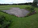
A rectangular embanked concrete structure survives just to the north of the remains of a squadron office. It is interpreted as rifle pit forming part of the Second World War airfield of RAF Harrowbeer. It is not clearly visible on the available aerial imagery.
Location
| Grid Reference: | SX 510 683 |
|---|
| Map Sheet: | SX56NW |
|---|
| Admin Area | Dartmoor National Park |
|---|
| Civil Parish | Buckland Monachorum |
|---|
| District | West Devon |
|---|
| Ecclesiastical Parish | BUCKLAND MONACHORUM |
|---|
Protected Status: none recorded
Other References/Statuses: none recorded
Monument Type(s) and Dates
- (Former Type) BLAST SHELTER (World War II - 1939 AD to 1945 AD (Between))
- RIFLE PIT (World War II - 1939 AD to 1945 AD (Between))
Full description
Ordnance Survey, 1904 - 1906, Second Edition Ordnance Survey 25 inch Map (Cartographic). SDV325644.
This area is depicted as rough ground.
Royal Air Force, 1946 - 1949, Royal Air Force Aerial Photographs, RAF/106G/UK/1190 RS 4198-4199 27-FEB-1946 (Aerial Photograph). SDV342938.
Two small earthwork mounds are visible.
Hayes, M., 2011, RAF Harrowbeer 1941-1945, 6 (Leaflet). SDV363809.
The structure is not depicted on the plan, but is just to the north of number 6, a squadron office.
Michel van Best and Peter Heijkoop, 2012, The Atlantikwall Website, http://www.atlantikwall.co.uk/atlantikwall/edev_harrowbeer.php (Website). SDV349925.
This structure is illustrated and described as a rifle defence pit, the openings being rifle slits and the contruction a lined trench with roof. Before RAF use it may have been used by the Home Guard or local army unit.
Hegarty, C., Knight, S. and Sims, R., 2019-2020, The South Devon Coast to Dartmoor Aerial Investigation and Mapping Survey. Area 2, Avon Valley to Plymouth (AI&M, formerly NMP) (Interpretation). SDV362982.
A rectangular embanked concrete structure survives just to the north of the remains of a squadron office forming part of the Second World War airfield of RAF Harrowbeer. It has openings very close to roof level on both sides, as would be expected of a blast shelter requiring ventilation. However the structure is narrower than other blast shelters on the airfield, with openings facing out across the airfield, and it is interpreted as a rifle defence pit by the Atlantikwall website. It was in reasonable condition on a site visit in 2020. It was not clearly visible on the available aerial imagery, although a hint of two earthwork mounds can be seen in this area on RAF aerial photographs taken in the immediate post-war period, suggetsing that it had been embanked or camouflaged.
Hegarty, C., Knight, S. and Sims, R., 2020, South Devon Coast to Dartmoor AI&M Survey, Area 2 Site Visit, 16-AUG-2020 (Site Visit). SDV363808.
An embanked structure is visible, with rectangular openings just below roof level.
Sources / Further Reading
| SDV325644 | Cartographic: Ordnance Survey. 1904 - 1906. Second Edition Ordnance Survey 25 inch Map. Second Edition Ordnance Survey 25 inch Map. Map (Digital). |
| |
| | |
| SDV342938 | Aerial Photograph: Royal Air Force. 1946 - 1949. Royal Air Force Aerial Photographs. Royal Air Force Aerial Photograph. Photograph (Digital). RAF/106G/UK/1190 RS 4198-4199 27-FEB-1946. |
| |
| | |
| SDV349925 | Website: Michel van Best and Peter Heijkoop. 2012. The Atlantikwall Website. http://www.vanderweel.info/atlantikwall/. Website. http://www.atlantikwall.co.uk/atlantikwall/edev_harrowbeer.php. |
| |
| | |
| SDV362982 | Interpretation: Hegarty, C., Knight, S. and Sims, R.. 2019-2020. The South Devon Coast to Dartmoor Aerial Investigation and Mapping Survey. Area 2, Avon Valley to Plymouth (AI&M, formerly NMP). Historic England Research Report. Digital. |
| |
| | |
| SDV363808 | Site Visit: Hegarty, C., Knight, S. and Sims, R.. 2020. South Devon Coast to Dartmoor AI&M Survey, Area 2 Site Visit. AC Archaeology. Photograph (Digital). 16-AUG-2020. [Mapped feature: #126819 ] |
| |  |
| | Linked images:14 |
| SDV363809 | Leaflet: Hayes, M.. 2011. RAF Harrowbeer 1941-1945. Leaflet. 6. |
| |
| | |
Associated Monuments
| MDV55691 | Part of: Harrowbeer Airfield, Buckland Monachorum (Monument) |
Associated Finds: none recorded
Associated Events
- EDV8098 - The South Devon Coast to Dartmoor Aerial Investigation and Mapping (formerly NMP) Survey, Area 2, Avon Valley to Plymouth (Ref: ACD2040)
| Date Last Edited: | Sep 14 2020 11:52AM |
|---|
Search results generated by the HBSMR Gateway from exeGesIS SDM Ltd.