See important
guidance on the use of this record.
If you have any comments or new information about this record, please email us.
| HER Number: | MDV14593 |
|---|
| Name: | Barnstaple Castle Moat |
|---|
Summary
The moat at Barnstaple Castle is probably contemporary with the 11th century motte. Excavation has shown that the moat was timber piled and filled with water from the river. A wet moat is considered to be an unusual feature for so early a castle. There is still a ditch around the north-east side of the motte.
Location
| Grid Reference: | SS 556 333 |
|---|
| Map Sheet: | SS53SE |
|---|
| Admin Area | Devon |
|---|
| Civil Parish | Barnstaple |
|---|
| District | North Devon |
|---|
| Ecclesiastical Parish | BARNSTAPLE |
|---|
Protected Status
Other References/Statuses
- Old DCC SMR Ref: SS53SE/43/2
- Old SAM County Ref: 255
- Old SAM Ref: 33062
- Ordnance Survey Archaeology Division: SS53SE14
- Ordnance Survey Archaeology Division: SS53SE14
Monument Type(s) and Dates
- MOAT (XI - 1100 AD to 1100 AD (Between))
Full description
Timms, S. C., 03/10/1983, Barnstaple Castle Moat (Personal Comment). SDV73912.
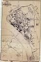
Depression recorded in 1953 still survives as grassed area to west of footpath. Land to east of footpath on south side of Dornat's building has been landscaped with trees and shrubs by the District Council. Wood's 1843 plan shows property boundary around mound which may outline ditch area.
Wood, J., 1843, Plan of the Town of Barnstaple from Actual Survey (Cartographic). SDV91852.
Oliver, B. W., 1928, The Castle of Barnstaple, 215-223, Plan (Article in Serial). SDV73002.
The moat at Barnstaple Castle was probably contemporary with motte of 1068-1069 and linking with the Rivers Taw to the west and south and the River Yeo to the north. Original depth was 14 feet (4.3 m)etres below present surface, and its width to present foot of the mound was 50 feet (15.24 metres). It may have had a retaining wall along its inner edge. It was crossed by a drawbridge.
Ministry of Works, 1950, Barnstaple Castle (Schedule Document). SDV73985.
Ditch visible on the north side.
Grant, A., 1981, The North Devon Pottery Industry of the Later Seventeenth Century (Extract) (Post-Graduate Thesis). SDV7737.
Course of moat in relation to post-medieval pottery area and 1971-74 excavations shown.
North Devon District Council Rescue Archaeology Unit, 1986, An Excavation at North Devon Area Library Site, Barnstaple; Summary Report (Report - Excavation). SDV76038.
The edge of the castle moat was excavated in 1885 showing the angle, slope and course of the original ditch. It was a massive feature at least 3 metres deep. Samples of the fill were taken for analysis.
Miles, T. J., 1986, The Excavation of a Saxon Cemetery and Part of the Norman Castle at North walk, Barnstaple, 72-3 (Article in Serial). SDV73913.
Part of the moat was found to be large and extended well below high water mark. A berm 4-5 metres wide had been left between the moat and the front of the rampart.
Lovatt, A. M., 1990, Excavations within a Medieval Town: North West Barnstaple 1985-1988, 4-5 (Report - Excavation). SDV64370.
The centre of the ditch was not reached, although the lowest layer, a light brown silty clay, produced pot of 1100-1300 and may be a primary deposit. Running parallel to the ditch was a shallow gully. The feature was sealed by dark brown loam containing pot dated 1500-1850. No modern porcelains above and below it.
Higham, R. A. + Freeman, J. P., 1996, Devon Castles (Draft Text), Gazetteer (Monograph). SDV354350.
The castle motte and its baileys were surrounded by ditches that excavation have revealed to be timber piled and filled with water from the river. Such wet moats are an unusual feature for so early a castle.
Department for Culture, Media and Sport, 2002, Barnstaple Castle (Schedule Document). SDV342276.
Barnstaple Castle comprises a courtyard or bailey area originally enclosed by a bank and moat which stood on the north west side of the motte.
Exeter Archaeology, 2003, Barnstaple Castle Car Park Scheme: Phase 1: Archaeological Assessment, 15, Fig. 11 (Report - Assessment). SDV319631.
Motte ditch excavated in 1927 and considered to be contemporary with the motte. Original depth may have been 4.3 metres by up to 15.25 metres wide with a retaining wall along the inner edge. The lower fills were waterlogged and humic. The ditch is visible as a slight depression over a length of 20 metres on the north side of the motte.
Ordnance Survey, 2013, MasterMap (Cartographic). SDV350786.
Dean, R., 2017, Barnstaple Castle, Barnstaple: Geophysics (Report - Survey). SDV360284.
This report was commissioned by North Devon Council. Magnetometer, resistance and ground penetrating radar (GPR) surveys were completed to inform upon the buried remains at Barnstaple Castle. The outer and inner castle baileys are now mainly urban parkland and were subject to magnetometer and resistance surveys. The tarmac carpark, which includes part of the former outer bailey and areas out with the scheduled monument, was subject to a ground penetrating radar (GPR) survey. The top of the motte was subject to surveys using all three techniques.
The castle comprises a courtyard or bailey area originally enclosed by a bank and moat, which stood on the north west side of a motte that was equipped with its own associated set of defences, thus creating a stronghold within the castle.
The moat at Barnstaple Castle is probably contemporary with the 11th century motte. Excavation has shown that the moat was timber piled and filled with 5 158 water from the river. A wet moat is considered to be an unusual feature for so early a castle. There is still a ditch around the north-east side of the motte.
The rampart and ditch which defended the bailey were part-excavated in 1972-75 and from these excavations it was suggested that the bailey rampart was about 10m wide and probably revetted with vertical timbers, although its height remains unknown. It was fronted by a berm 4m-5m wide and then a ditch which, because its depth has been demonstrated to be well below the high water mark, may be more correctly termed as a moat fed by channels connected to the River Yeo. The full width of the bailey moat has not yet been established although it appears to exceed 5m. A flat-bottomed trench located between the rampart and the ditch is considered to be a robber-trench of a stone wall about 1m thick which was added to the front of the rampart in the late medieval period.
As with the bailey, the motte mound was surrounded by an encircling moat found in an excavation of 1927 to be about 16m wide and 4.5m deep. The motte must have been connected to the bailey by some means, probably by a drawbridge. A moat of this size is also likely to have utilised river water by the linking of the nearby Rivers Taw and Yeo, although it was not until the 13th century that castle defences made extensive use of water-filled moats, and Barnstaple Castle appears to have been in decline by then.
Excavations within the castle grounds in 1972-75 on the north west side of the motte in the area thought to encompass the bailey and its defences, revealed the presence of 105 graves forming part of a Saxon cemetery which was in use at the time of the Norman Conquest. All of the excavated burials were extended inhumations orientated east-west and all lacked grave goods. The cemetery was therefore deemed to be Christian and it may date to about 900, but would have ceased to be used as such when the moat and rampart of the Norman castle were constructed across the site. Further burials are expected to lie in those undisturbed areas within
the castle grounds which were not subject to archaeological investigation.
Although it was landscaped in the 19th century, Barnstaple Castle still retains the basic features of a medieval motte and bailey castle and its motte in particular survives in excellent condition as a well known and dominant feature in the western part of the town. The monument will retain archaeological information about the Saxon population of the town from unexcavated burials. The monument will also be instructive about Norman fortification techniques, in particular with regard to moat construction. The location of the castle on a Saxon burial site indicates something of the relationship between the Norman rulers and the population of the Saxon burh which preceded it. Artefacts and organic remains lying within the moat, some of which may survive well due to waterlogging, will shed light on the lives of the inhabitants of the castle, and their surrounding contemporary landscape. The extant motte provides a visual reminder of the steps which were necessary to establish Norman rule in England by the construction of impressive and strongly defended motte and bailey castles, in this case not only within the recognised boundaries of the Anglo-Saxon town itself, but overlying the earlier Saxon cemetery.
Group r25 may represent part of the former motte moat (scheduled listing 1020922) but is more likely to represent recent deposits created during park landscaping.
Ordnance Survey Archaeology Division, Unknown, SS53SE14 (Ordnance Survey Archaeology Division Card). SDV73910.
Site visit: 15th October 1953. Only visible trace is turf covered shallow depression to north and at base of mound. Depression (length 20.0 metres width 12.6 metres) site of western portion of moat is laid out as ornamental gardens, and south and east sides form part of cattle market. No visible traces of retaining wall.
Sources / Further Reading
| SDV319631 | Report - Assessment: Exeter Archaeology. 2003. Barnstaple Castle Car Park Scheme: Phase 1: Archaeological Assessment. Exeter Archaeology Report. 03.62. A4 Stapled + Digital. 15, Fig. 11. |
| |
| | |
| SDV342276 | Schedule Document: Department for Culture, Media and Sport. 2002. Barnstaple Castle. The Schedule of Monuments. A4 Stapled. |
| |
| | |
| SDV350786 | Cartographic: Ordnance Survey. 2013. MasterMap. Ordnance Survey Digital Mapping. Digital. [Mapped feature: #81292 ] |
| |
| | |
| SDV354350 | Monograph: Higham, R. A. + Freeman, J. P.. 1996. Devon Castles (Draft Text). Devon Castles. A4 Unbound + Digital. Gazetteer. |
| |
| | |
| SDV360284 | Report - Survey: Dean, R.. 2017. Barnstaple Castle, Barnstaple: Geophysics. Substrata. 1702BAR-R-1. Digital. |
| |
| | |
| SDV64370 | Report - Excavation: Lovatt, A. M.. 1990. Excavations within a Medieval Town: North West Barnstaple 1985-1988. North Devon District Council Rescue Archaeology Unit Report. A4 Grip Bound + Digital. 4-5. |
| |
| | |
| SDV73002 | Article in Serial: Oliver, B. W.. 1928. The Castle of Barnstaple. Transactions of the Devonshire Association. 60. A5 Hardback. 215-223, Plan. |
| |
| | |
| SDV73910 | Ordnance Survey Archaeology Division Card: Ordnance Survey Archaeology Division. Unknown. SS53SE14. Ordnance Survey Archaeology Division Card. Card Index. |
| |
| | |
| SDV73912 | Personal Comment: Timms, S. C.. 03/10/1983. Barnstaple Castle Moat. Not Applicable. |
| SDV73913 | Article in Serial: Miles, T. J.. 1986. The Excavation of a Saxon Cemetery and Part of the Norman Castle at North walk, Barnstaple. Proceedings of the Devon Archaeological Society. 44. Paperback Volume. 72-3. |
| |
| | |
| SDV73985 | Schedule Document: Ministry of Works. 1950. Barnstaple Castle. The Schedule of Monuments. Foolscap. |
| |
| | |
| SDV76038 | Report - Excavation: North Devon District Council Rescue Archaeology Unit. 1986. An Excavation at North Devon Area Library Site, Barnstaple; Summary Report. North Devon District Council Rescue Archaeology Unit Report. A4 Stapled + Digital. |
| |
| | |
| SDV7737 | Post-Graduate Thesis: Grant, A.. 1981. The North Devon Pottery Industry of the Later Seventeenth Century (Extract). Exeter University PhD Thesis. A4 Stapled + Digital. |
| |
| | |
| SDV91852 | Cartographic: Wood, J.. 1843. Plan of the Town of Barnstaple from Actual Survey. Unknown. |
| |  |
| | Linked images:1 |
Associated Monuments
| MDV14592 | Part of: Barnstaple Castle (Monument) |
| MDV14594 | Related to: Barnstaple Castle Inner Bailey (Monument) |
| MDV19999 | Related to: Barnstaple Castle Motte (Monument) |
| MDV14595 | Related to: Barnstaple Castle Outer Bailey (Monument) |
| MDV50027 | Related to: Workshop or Warehouse close to Barnstaple Castle (Building) |
Associated Finds
- FDV1368 - POT (XI to XIII - 1100 AD to 1300 AD)
Associated Events
- EDV1378 - Barnstaple Castle Car Park Scheme Archaeological Assessment
- EDV4504 - Excavation at Library Site in Barnstaple
- EDV7313 - Geophysics: Barnstaple Castle, Barnstaple (Ref: 1702BAR-R-1)
| Date Last Edited: | Jul 27 2017 3:22PM |
|---|
Search results generated by the HBSMR Gateway from exeGesIS SDM Ltd.