See important
guidance on the use of this record.
If you have any comments or new information about this record, please email us.
| HER Number: | MDV23835 |
|---|
| Name: | The Old Mill, Lee, Ilfracombe |
|---|
Summary
Former corn mill now a holiday cottage. The building possibly dates from the late 16th century but it has been much altered, particularly in the 19th century. The mill which is recorded in a lease of 1761 and ran until the late 19th/early 20th century. The waterwheel, which was on the seaward side of the buildings, was removed in the 1890s.
Location
| Grid Reference: | SS 480 465 |
|---|
| Map Sheet: | SS44NE |
|---|
| Admin Area | Devon |
|---|
| Civil Parish | Ilfracombe |
|---|
| District | North Devon |
|---|
| Ecclesiastical Parish | ILFRACOMBE |
|---|
Protected Status
Other References/Statuses
- Old DCC SMR Ref: SS44NE/35
- Old Listed Building Ref (II)
Monument Type(s) and Dates
- WATERMILL (Built, XVI - 1501 AD to 1600 AD (Between))
Full description
Department of Environment, Untitled Source (Migrated Record). SDV328447.
The old mill, lee. Date on signboard 1560. The centre part, which has massive external stone chimney and porch beside it, may be of this date. L-shaped 2 storey stone structure, partly whitewashed, on edge of beach. Sash windows with glazing bars, ground floor windows and entrance with segmental heads. Its background of cliff and rock matches the material of its structure and its low garden walls. In this position it is a very attractive building. Trellis porch. One early c19 casement with gothic heads to lights (doe).
NDAS, Untitled Source (Report - Survey). SDV63003.
Vis=1974 (ndas) the old mill, lee bay. The overshot waterwheel does not survive, but it is believed to have been made of cast iron with wooden buckets and to have been 14ft in diameter by 3ft 6in wide. It was sited at the sea side of the house. The remainder of the machinery, apart from the millstones, does not survive. The building is constructed of stone and cob with a slate roof. A stone-lined leat brought water to the wheel from a pond (now the garden) and was fed from the stream running through the valley. Until 1905 it was a flour mill grinding locally grown corn. Originally there was a barn, one cottage, and a bakehouse here. It is now a tea room (ndas).
NDAS, Untitled Source (Report - Survey). SDV63004.
Vis=1989 (ndas) the mill house is still in good condition (ndas).
Untitled Source (Migrated Record). SDV63006.
Doe/hhr:ilfracombe/(17/6/1973)18.
Untitled Source (Migrated Record). SDV63007.
Ndas/north devon watermills/(1989)48.
Untitled Source (Migrated Record). SDV63008.
Watermills in north devon 1994/(1995) 87/in smr.
WATERMILLS, Untitled Source (Migrated Record). SDV18616.
Vis=estimated -/-/1994 (watermills)nothing remains except the wheel pit and a catch pit at garden level, presumably fed by the leat. The mill house is part of the occupied property. The stone floor covers where the machinery was. The loft is still there. The leat is now covered in. Apparently the water to drive the mill was conveyed by means of a leat that ran from the back of the mill house and along the side of the road at the back of the lee bay hotel. Traces of it can still be seen here. It was fed from a pond situated at the bottom of catskull hill. This millpond was in turn fed by a leat which brought water along the side of lee meadow from the north corner of yonder meadow. Here the natural stream makes an abrupt right-angled turn, and sluice gates were installed at this point. They were still there in 1960, although in a terrible state of disrepair. Recently a large pond has been gouged out at this spot. The slight depression near the wall in the field below southcliffe is the visible remains of another leat. In a dry period, when the main stream was running low, water could be moved by means of this leat from the stream that flows under borough valley and into the main stream, the actual junction being on the footpath to the beach, just past the side door of the gate house. At some time during the 1890s, the squire had the waterwheel removed (watermills).
Ordnance Survey, 1880-1899, First Edition Ordnance 25 inch map (Cartographic). SDV336179.
Corn Mill marked.
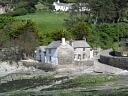
Watts, S., 19/05/2015, Old Mill, Lee, Ilfracombe (Ground Photograph). SDV358348.
The waterwheel was on the seaward side of the buildings. Now a holiday cottage.
Bodman, M., 2003, Watermills and Other Water-Powered Sites in Devon, 152 (Report - Interim). SDV325576.
The mill is sited right on the coast and is now a private residence. It is recorded as a grist mill in a lease of 1761. James Parkin is named as a corn miller at Lee in White's Directory of Devon for 1850.
Collings, A. G. + Manning, P. T. + Valentin, J., 2007, The North Devon Area of Outstanding Natural Beauty. Phase 1. Archaeological Survey. Summary Report, No. 817 (Report - Assessment). SDV339712.
Ordnance Survey, 2015, MasterMap (Cartographic). SDV357601.
Historic England, 2015, National Heritage List for England (National Heritage List for England). SDV358087.
The Old Mill. House. Possibly late C16; much altered, particularly in the C19. Random rubble slate; Welsh slate roofs. Originally a 3-unit cross-passage plan house with a C19 front wing, forming an L-shape overall. The former service end to the left of the passage has been largely dismantled and lowered; consequently the roofs of the main range and the wing do not join. Front: irregular 3-window range with massive front lateral stack to right of porch which has a room over with catslide. This room has a casement with 2 pointed lights; the other 1st-floor windows with 9-pane hornless sashes; 12-pane sashes to ground flank C19 doorway (all under segmental heads). Former cross-passage has old planked door under a cranked lintel. Right-hand end stack. Wing (with gable stack) has sash windows. INTERIOR not inspected. The house occupies an important position above the beach.
Sources / Further Reading
| SDV18616 | Migrated Record: WATERMILLS. |
| SDV325576 | Report - Interim: Bodman, M.. 2003. Watermills and Other Water-Powered Sites in Devon. A4 Spiral Bound. 152. |
| |
| | |
| SDV328447 | Migrated Record: Department of Environment. |
| SDV336179 | Cartographic: Ordnance Survey. 1880-1899. First Edition Ordnance 25 inch map. First Edition Ordnance Survey 25 inch Map. Map (Digital). |
| |
| | |
| SDV339712 | Report - Assessment: Collings, A. G. + Manning, P. T. + Valentin, J.. 2007. The North Devon Area of Outstanding Natural Beauty. Phase 1. Archaeological Survey. Summary Report. Exeter Archaeology Report. 06.22 (rev.1). A4 Stapled + Digital. No. 817. |
| |
| | |
| SDV357601 | Cartographic: Ordnance Survey. 2015. MasterMap. Ordnance Survey Digital Mapping. Digital. [Mapped feature: #84321 ] |
| |
| | |
| SDV358087 | National Heritage List for England: Historic England. 2015. National Heritage List for England. Website. |
| |
| | |
| SDV358348 | Ground Photograph: Watts, S.. 19/05/2015. Old Mill, Lee, Ilfracombe. Digital. |
| |  |
| | Linked images:1 |
| SDV63003 | Report - Survey: NDAS. |
| |
| | |
| SDV63004 | Report - Survey: NDAS. |
| |
| | |
| SDV63006 | Migrated Record: |
| SDV63007 | Migrated Record: |
| SDV63008 | Migrated Record: |
Associated Monuments
| MDV31215 | Related to: Leat to The Old Mill, Lee, Ilfracombe (Monument) |
Associated Finds: none recorded
Associated Events: none recorded
| Date Last Edited: | Jan 29 2016 2:46PM |
|---|
Search results generated by the HBSMR Gateway from exeGesIS SDM Ltd.