See important
guidance on the use of this record.
If you have any comments or new information about this record, please email us.
| HER Number: | MDV49431 |
|---|
| Name: | Military Hospital, Millwey Rise, Axminster |
|---|
Summary
Site of a Second World War United States military hospital, visible as a complex of structures, trackways and earthworks on aerial photographs taken in the 1940s. The site was subsequently used then redeveloped for housing but some original buildings still remain such as the garages and Millwey Rise workshops.
Location
| Grid Reference: | SY 306 992 |
|---|
| Map Sheet: | SY39NW |
|---|
| Admin Area | Devon |
|---|
| Civil Parish | Axminster |
|---|
| District | East Devon |
|---|
| Ecclesiastical Parish | AXMINSTER |
|---|
Protected Status
- SHINE: Geophysical anomalies representing archaeological activity including possible deposits of burnt material, pits and other soil-filled features, a barrow and the remains of buildings to the east of Axminster
- SHINE: Earthworks and structures associated with the Weycroft Defence Area on the World War Two 'Taunton Stop Line' and cropmarks of a rectangular enclosure of unknown date east of Weycroft
Other References/Statuses
- Old DCC SMR Ref: SY39NW/71
- SHINE Candidate (Yes)
Monument Type(s) and Dates
- MILITARY HOSPITAL (World War II - 1939 AD to 1945 AD)
Full description
Royal Air Force, 1946 - 1949, Royal Air Force Aerial Photographs (Aerial Photograph). SDV342938.
Map object previously based on this Source.
Royal Air Force, 1947, RAF/CPE/UK/1974, RAF/CPE/UK/1974 FP 1422-1423 11-APR-1947 (Aerial Photograph). SDV356127.
A substantial complex of structures, tracks and earthworks is visible. Map object partly based on this source.
Royal Air Force, 1948, RAF/CPE/UK/2431, RAF/CPE/UK/2431 RP 3200-3201 22-JAN-1948 (Aerial Photograph). SDV359315.
A substantial complex of structures, tracks and earthworks is visible. Map object partly based on this source.
Royal Air Force, 1948, RAF/CPE/UK/2431/3200 (Aerial Photograph). SDV132197.
Military complex visible on 1948 Royal Air Force aerial photograph.
Ordnance Survey, 1963, SY39NW (Cartographic). SDV348711.
Part of the complex appears on the 1963 6 inch Ordnance Survey map. By this time parts had been converted to a special centre, works and housing.
Ordnance Survey, 1973, SY29/39 (Cartographic). SDV348821.
By 1973 much of the area had been developed as the Millwey Rise estate.
Ordnance Survey, 1976, OS/76051, OS/76051 V 018-019 08-MAY-1976 (Aerial Photograph). SDV359323.
Much of the area has been developed for housing, but two hut bases and two curved-roofed superstructures are visible.
Devon County Council, 1993, Millway Rise Industrial Estate, Axminster (Leaflet). SDV325584.
Single World War II hut recorded on aerial photograph on front of Devon County Council sale brochure.
Horner, B., 1994, Axminster Strong Point (Personal Comment). SDV348804.
This was the site of an United States military hospital.
Marshwood Vale Magazine, 2005, The Marshwood Vale Magazine, http://www.marshwoodvale.com/people/2005/09/julia-mear/ (Website). SDV360164.
This article includes reference to the American-built Nissen huts at Millwey Rise being provided as temporary accommodation for families in 1948.
Next Perspectives, 2010, Aerial Photography for Great Britain, Next Perspectives APGB Imagery SY3099 23-MAY-2010 (Aerial Photograph). SDV359317.
One curved roofed superstructure is visible at circa 330596,99532.
Next Perspectives, 2014, Aerial Photography for Great Britain, Next Perspectives APGB Imagery SY3098 08-SEP-2014 (Aerial Photograph). SDV359479.
No Second World War superstructures are visible.
Action East Devon, 2016, Action East Devon, http://www.actioneastdevon.org.uk/projects/axminster-remembers/ (Website). SDV360166.
The webpage states that Axminster housed the United States Army 315th Station hospital in the period before and after the D-Day landings.
Hegarty, C. + Knight, S. + Sims, R., 2016-2018, The Blackdown Hills AONB and East Devon River Catchments National Mapping Programme Project (Interpretation). SDV359463.
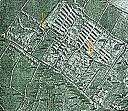
A substantial complex of structures, trackways and earthworks is visible on aerial photographs taken in the 1940s, covering over 20 hectares to the north-east of Axminster, the site of a Second World War United States 315th station hospital. Double-rows of long pitched roofed structures were present in the east of the area, and smaller pitched- and curved-roofed structures in the west. At circa 5 by 11 metres in plan these could be Nissen huts, and Sturch describes the furthest north as a Nissen hut (2017). The structures are linked by well-defined trackways, some fairly deeply incised and others probably concrete, and by covered corridors. A possible exercise area is visible as an enclosed trapezoidal area in the south-east of the complex and there are several smaller rectilinear banked or fenced enclosures. What appears to be a water treatment works is sites to the west (MDV119032). After the war the hospital site was reused for domestic housing and subsequent phases of redevelopment finally removed the last of the Nissen-type huts between 2010 and 2014.
The complex has been transcribed from the Historic England Archive 1940s aerial photographs, which have been recorded here as an additional separate source because there is a possibility that the prints may have been processed differently. This would potentially result in images on which archaeological features show slightly differently.
Action East Devon, 2017, Axminster Remembers, http://axremembers.actioneastdevon.org.uk/axminster-stories/norma-and-delphine (Website). SDV360244.
This oral history recording includes reference to The Camp consisting of Nissen huts for accommodation, with operating theatres in brick structures. The interviewees say that there were sometimes dances in the camp, and also that James Cagney once visited although he stayed in the George Hotel in Axminster. After the war they say that some demobbed soldiers squatted in the camp due to lack of housing, and that eventually this settlement was formalised. They state that toilet blocks were present at the ends of the blocks.
East Devon District Council, 2017, East Devon District Council, http://eastdevon.gov.uk/news/2017/03/new-apple-trees-for-millwey-community-orchard/ (Website). SDV360165.
An article dated 23 March 2017 discusses a new community orchard near St George’s Avenue in Axminster. The local Councillor is quoted as saying “While digging one of the holes we found evidence of the original old World War Two American army camp hospital site, which Millwey Rise itself was built on. The remaining rubble offered good drainage properties for the trees we were planting".
Sturch, D., 2017, Rhymes of Life 1947-1952 "The Camp" (Millwey Rise), 2-4, 10 (Pamphlet). SDV361029.
An aerial photograph dating to 1947 is annotated with features including the Nissen hut and admin office that Sturch, D. lived in between 1947 and 1952 (at circa 330727,99556 and 330596,99247 respectively), a water tank (at circa 330655,99174), the main entrance (at 330448,99285) and the above-ground hospital reservoir (at approximately 330830,99177). The admin office is described as single brick with iron trusses.
A newspaper article (Pulmans Weekly News) from 10th November 1946 is quoted as saying the Americans had left several months beforehand, and that there was no supply of water and electricity when the first civilians had moved into the unlocked wards earlier that week.
EastDevon24, 2018, EastDevon24, http://www.eastdevon24.co.uk/news/life-in-the-camp-at-axminster-detailed-in-new-book-1-5229966 (Website). SDV360864.
The article describes how a family occupied first an empty Nissen hut in 1947, then the hospitals administration office for four years, before moving into one of the 'Cornish Unit' council houses which were replacing the military structures. An image of the hospital showing several pitched-roofed huts and tents is included, and it appears that the tents may have been located in the trapezoidal enclosed area or the space between the ward buildings, at circa 330752,99157.
Sturch, D., 2021, Images, Military Hospital, Millwey Rise, Axminster (Correspondence). SDV364659.
Two examples of the single storey brick and asbestos roofed buildings still remain although with some modification. The aerial photo shows No.1 is now Millwey Rise Workshops on Second Avenue part of the new industrial estate. No.2 is now a row of garages at the bottom of Bonners Causeway but the original structures are still as they were. Annotated RAF show the toilet block, Cloakham Lodge, vehical inspection, nissen huts and a covered reservoir. Two ground shots show the modernised buildings.
Sources / Further Reading
| SDV132197 | Aerial Photograph: Royal Air Force. 1948. RAF/CPE/UK/2431/3200. Royal Air Force Aerial Photograph. Unknown. |
| |
| | |
| SDV325584 | Leaflet: Devon County Council. 1993. Millway Rise Industrial Estate, Axminster. Devon Estates Practice, Sales Brochure. A4 Stapled + Digital. |
| |
| | |
| SDV342938 | Aerial Photograph: Royal Air Force. 1946 - 1949. Royal Air Force Aerial Photographs. Royal Air Force Aerial Photograph. Photograph (Digital). |
| |
| | |
| SDV348711 | Cartographic: Ordnance Survey. 1963. SY39NW. Ordnance Survey 6 inch map. Map (Paper). |
| |
| | |
| SDV348804 | Personal Comment: Horner, B.. 1994. Axminster Strong Point. Not Applicable. |
| SDV348821 | Cartographic: Ordnance Survey. 1973. SY29/39. Ordnance Survey 1:2500 Map. Map (Paper). |
| |
| | |
| SDV356127 | Aerial Photograph: Royal Air Force. 1947. RAF/CPE/UK/1974. Royal Air Force Aerial Photograph. Photograph (Paper). RAF/CPE/UK/1974 FP 1422-1423 11-APR-1947. |
| |
| | |
| SDV359315 | Aerial Photograph: Royal Air Force. 1948. RAF/CPE/UK/2431. Royal Air Force Aerial Photograph. Photograph (Paper). RAF/CPE/UK/2431 RP 3200-3201 22-JAN-1948. |
| |
| | |
| SDV359317 | Aerial Photograph: Next Perspectives. 2010. Aerial Photography for Great Britain. Aerial Photography for Great Britain Aerial Photographs. Digital. Next Perspectives APGB Imagery SY3099 23-MAY-2010. |
| |
| | |
| SDV359323 | Aerial Photograph: Ordnance Survey. 1976. OS/76051. Ordnance Survey Aerial Photograph. Photograph (Paper). OS/76051 V 018-019 08-MAY-1976. |
| |
| | |
| SDV359463 | Interpretation: Hegarty, C. + Knight, S. + Sims, R.. 2016-2018. The Blackdown Hills AONB and East Devon River Catchments National Mapping Programme Project. Historic England Research Report. Digital. |
| |  |
| | Linked documents:2 |
| SDV359479 | Aerial Photograph: Next Perspectives. 2014. Aerial Photography for Great Britain. Digital. Next Perspectives APGB Imagery SY3098 08-SEP-2014. |
| |
| | |
| SDV360164 | Website: Marshwood Vale Magazine. 2005. The Marshwood Vale Magazine. http://www.marshwoodvale.com/. Website. http://www.marshwoodvale.com/people/2005/09/julia-mear/. |
| |  |
| | Linked documents:1 |
| SDV360165 | Website: East Devon District Council. 2017. East Devon District Council. http://eastdevon.gov.uk\. Website. http://eastdevon.gov.uk/news/2017/03/new-apple-trees-for-millwey-community-orchard/. |
| | |
| | |
| SDV360166 | Website: Action East Devon. 2016. Action East Devon. http://www.actioneastdevon.org.uk/. Website. http://www.actioneastdevon.org.uk/projects/axminster-remembers/. |
| |  |
| | Linked documents:1 |
| SDV360244 | Website: Action East Devon. 2017. Axminster Remembers. http://axremembers.actioneastdevon.org.uk. Website. http://axremembers.actioneastdevon.org.uk/axminster-stories/norma-and-delphine. |
| |
| | |
| SDV360864 | Website: EastDevon24. 2018. EastDevon24. http://www.eastdevon24.co.uk. Digital. http://www.eastdevon24.co.uk/news/life-in-the-camp-at-axminster-detailed-in-new-book-1-5229966. |
| |
| | |
| SDV361029 | Pamphlet: Sturch, D.. 2017. Rhymes of Life 1947-1952 "The Camp" (Millwey Rise). A5 Stapled. 2-4, 10. |
| |
| | |
| SDV364659 | Correspondence: Sturch, D.. 2021. Images, Military Hospital, Millwey Rise, Axminster. Additional information for HER. Email + Digital. |
| |  |
| | Linked images:2 |
Associated Monuments
| MDV105853 | Related to: Millwey Rise War Memorial Plaque (Monument) |
| MDV119032 | Related to: Water Treatment Works north of Cloakham Lawn, Axminster (Monument) |
Associated Finds: none recorded
Associated Events
- EDV7508 - The Blackdown Hills AONB and East Devon River Catchments National Mapping Programme (NMP) project (Ref: ACD1228)
| Date Last Edited: | Dec 6 2021 1:08PM |
|---|
Search results generated by the HBSMR Gateway from exeGesIS SDM Ltd.