See important
guidance on the use of this record.
If you have any comments or new information about this record, please email us.
| HER Number: | MDV52723 |
|---|
| Name: | Limekiln to the south of Sprey Point, Teignmouth |
|---|
Summary
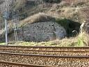
Remains of a limekiln. It was probably built in the mid 19th century to facilitate the construction of the railway line. Pairs of holes in the structure have led to the suggestion that it was adapted for use as a defence position during the Second World War, but they could equally well be drainage holes.
Location
| Grid Reference: | SX 948 736 |
|---|
| Map Sheet: | SX97SW |
|---|
| Admin Area | Devon |
|---|
| Civil Parish | Teignmouth |
|---|
| District | Teignbridge |
|---|
| Ecclesiastical Parish | EAST TEIGNMOUTH |
|---|
Protected Status: none recorded
Other References/Statuses
- National Monuments Record: 1429702
- Old DCC SMR Ref: SX97SW/225
Monument Type(s) and Dates
- LIME KILN (XIX - 1801 AD to 1900 AD (Between))
- LOOPHOLED WALL (World War II - 1939 AD to 1945 AD)
Full description
Ordnance Survey, 1880-1899, First Edition Ordnance 25 inch map (Cartographic). SDV336179.
Limekiln marked on landward side of railway, to the south of Sprey Point, east of East Cliff Walk.
Ordnance Survey, 1930 - 1939, Fourth Edition Ordnance Survey 25 inch Map (Cartographic). SDV336668.
'Old Limekiln' marked.
Council for British Archaeology, 2002, Defence of Britain Archive, 15682 (Website). SDV349686.
Standing close to the up-line, this loopholed wall (or possible pillbox) is built of natural stone and is bedded into the undercliff from which the railway cutting was constructed. The entrance can just be detected at the higher end of the structure. Possibly there is no roof, in which case it is best described as a loopholed wall. Three pairs of loopholes for rifles are to be seen. The structure faces towards the sea, which at high tide is not more than thirty yards away.
Whiteaway, T., 2012, HER Enquiries (Correspondence). SDV349687.
The site of a limekiln marked on the 1889 25 inch Ordnance Survey map appears to be the same structure as that listed in the Defence of Britain Archive as a Loopholed Wall or pillbox.
Ordnance Survey, 2012, MasterMap (Cartographic). SDV348725.
North-east and south-east walls marked.
Thompson, S., 2012, Re: WWII Defence Sites for Inclusion in the HER (Correspondence). SDV349856.
The structure does not appear to be defensive in nature. The holes are too high and too close together to be embrasures and are more likely to be drains to allow the surface water to run off from behind the wall.
Thompson, S., 2012, WWII defence sites for inclusion in the HER (Correspondence). SDV349685.
Considered to be a strange place to build a loop-holed wall. Possibly an adapted limekiln. Better terned defence post rather than loop-holed wall.
Pink, F., 2014-2015, South Devon Coast Rapid Coastal Zone Assessment Survey Desk-Based Assessment (Interpretation). SDV357736.
Historic England, 2018, Former Platelayers Cabin south of Sprey Point, Former Lime Kiln south of Sprey Point, Storage Building north end of Sprey Point, Teignmouth. (List of Blds of Arch or Historic Interest). SDV360796.
Historic England has been asked to assess a number of structures on the railway line between
Dawlish and Teignmouth, Devon for listing through a request for a Certificate of Immunity (COI) from Listing. These structures include the line side buildings and structure around Sprey Point which are the subject of this assessment.
Approximately 220m to the south of Sprey Point are the remains of a lime kiln. It appears on late-C19 plans and maps and it was probably built in the mid-C19, after the railway was first established, to facilitate the construction and maintenance of the line. It has been suggested that the structure is a pillbox; however, it is clearly identified as a lime kiln on several historical Ordnance Survey maps and plans, and this conforms with its appearance. It had become disused by the early C20.
Details
A former lime kiln built in around the mid-C19.
MATERIALS: constructed of rubble stone with a sloping earthen roof.
PLAN: south-east and north-east sloping walls, between 1 to 4m high, with a curved east
corner.
DESCRIPTION: lime kiln faces north-east and has been built against the sandstone cliff face on the north-west side of the railway track. The long retaining wall faces south-east and the shorter section of wall faces north-east. At the base of the east corner is a small arched opening supported by a reused steel rail, and in the wall above are three pairs of putlog holes. The arch has been partially infilled and the ground level around the structure has been raised.
Historic England, 2018, Two Trackside Buildings and a Lime Kiln Around Sprey Point (List of Blds of Arch or Historic Interest). SDV361188.
Notification that following a recommendation from Historic England, the Secretary of State for Digital, Culture, Media and Sport has decided not to list the limekiln and trackside buildings but is minded to issue a Certificate of Immunity from Listing (COI).
The South Devon Railway was first laid out in 1846 and designed by Isambard Kingdom Brunel during the pioneering phase of railway development in Britain. The trackside buildings and the lime kiln near to Sprey Point do not appear on William Dawson's 1840s drawings of the railway. They are, however, shown on South Devon Railway's 1874 survey. The former platelayer's building and the lime kiln on the north side of the tracks appear to have been partially buried when the line was widened in the 1880s.
The FORMER PLATELAYER'S BUILDING on the north side of the railway line has lost its roof and is very overgrown. Its walls are of simple rubble-stone construction and have been partially buried since the line was widened in the 1880s. The other TRACKSIDE BUILDING at Sprey Point, on the south side of the line, retains a greater proportion of its fabric. However, it is a modest single-storey structure with a simple pitched-roof and a single arched opening in the north gable wall. The roof has been recovered with corrugated metal sheets. Both of these buildings are plain, functional structures which lack architectural interest. The C19 LIME KILN it not a particularly early example of its type. There are several examples of listed lime kilns associated with railways, including a five-kiln structure at Bollihope Burn in Stanhope, County Durham built for the Stockton and Darlington Railway Company (late 1840s, Grade II). In comparison, the lime kiln near Sprey Point is a simple, single-kiln structure. It also does not form part of a larger group of associated listed industrial or transport structures and is not of sufficient architectural or technological interest to merit listing.
All three structures have local historic interest as features associated with this early railway line which was established by Brunel and they relate to the maintenance of this prominent coastal railway route. However, as plain, functional structures they are not of sufficient special architectural or historic interest to merit listing. After examining all the records and other relevant information and having carefully considered the architectural and historic interest of this case, the criteria for listing are not fulfilled. Certificates of Immunity from Listing are recommended for the two trackside buildings and the nearby lime kiln at Sprey Point.
REASONS FOR DESIGNATION DECISION
It is recommended that Certificates of Immunity from Listing should be issued for the two trackside buildings and the lime kiln on the railway line to the east of Teignmouth for the following principal reasons:
Architectural interest:
* these mid-/late-C19 structures are architecturally plain and lack any technological or design interest;
* the former platelayer's building has lost a significant amount of original fabric; the other trackside building and the lime kiln survive comparatively well, but are architecturally modest.
Historic interest:
* the structures are situated on the former South Devon Railway which was first established in 1846 and designed by Brunel. However, this association is not sufficient to compensate for the lack of architectural or technological interest for these ancillary railway structures.
Group value:
* they do not form a group with any listed railway or transport structures.
See report for further details.
Historic England, 2018, Two Trackside Buildings and a Lime Kiln Around Sprey Point (List of Blds of Arch or Historic Interest). SDV361207.
Confirmation that the limekiln has been issued with a Certificate of Immunity from listing for five years.
Watts, S., 21/02/2015, Limekiln at Teignmouth (Ground Photograph). SDV357910.
Sources / Further Reading
| SDV336179 | Cartographic: Ordnance Survey. 1880-1899. First Edition Ordnance 25 inch map. First Edition Ordnance Survey 25 inch Map. Map (Digital). [Mapped feature: #94420 ] |
| |
| | |
| SDV336668 | Cartographic: Ordnance Survey. 1930 - 1939. Fourth Edition Ordnance Survey 25 inch Map. Fourth Edition Ordnance Survey 25 inch Map. Map (Digital). |
| |
| | |
| SDV348725 | Cartographic: Ordnance Survey. 2012. MasterMap. Ordnance Survey. Map (Digital). |
| |
| | |
| SDV349685 | Correspondence: Thompson, S.. 2012. WWII defence sites for inclusion in the HER. Email to S. Watts. Email. |
| SDV349686 | Website: Council for British Archaeology. 2002. Defence of Britain Archive. http://archaeologydataservice.ac.uk/archives/view/dob/. Website. 15682. |
| |
| | |
| SDV349687 | Correspondence: Whiteaway, T.. 2012. HER Enquiries. Email to Historic Environment Team. Email. |
| SDV349856 | Correspondence: Thompson, S.. 2012. Re: WWII Defence Sites for Inclusion in the HER. Email to S. Watts. Email. |
| SDV357736 | Interpretation: Pink, F.. 2014-2015. South Devon Coast Rapid Coastal Zone Assessment Survey Desk-Based Assessment. AC Archaeology Report. Digital. |
| |  |
| | Linked documents:1 |
| SDV357910 | Ground Photograph: Watts, S.. 21/02/2015. Limekiln at Teignmouth. Photograph (Digital). |
| |  |
| | Linked images:1 |
| SDV360796 | List of Blds of Arch or Historic Interest: Historic England. 2018. Former Platelayers Cabin south of Sprey Point, Former Lime Kiln south of Sprey Point, Storage Building north end of Sprey Point, Teignmouth.. Certificate of Immunity. Digital. |
| |
| | |
| SDV361188 | List of Blds of Arch or Historic Interest: Historic England. 2018. Two Trackside Buildings and a Lime Kiln Around Sprey Point. Notification of Intention to Grant a Certificate of Immunity. Digital. |
| |
| | |
| SDV361207 | List of Blds of Arch or Historic Interest: Historic England. 2018. Two Trackside Buildings and a Lime Kiln Around Sprey Point. Notification of Certificate of Immunity. Digital. |
| |
| | |
Associated Monuments
| MDV110073 | Related to: Former Platelayers Cabin, south of Sprey Point, Teignmouth (Building) |
Associated Finds: none recorded
Associated Events: none recorded
| Date Last Edited: | Aug 5 2019 4:31PM |
|---|
Search results generated by the HBSMR Gateway from exeGesIS SDM Ltd.