See important
guidance on the use of this record.
If you have any comments or new information about this record, please email us.
| HER Number: | MDV71809 |
|---|
| Name: | Site 1, Light Anti-Aircraft Battery at Harrowbeer, Buckland Monachorum |
|---|
Summary
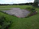
A light anti-aircraft battery at Harrowbeer corresponds to a complex of structures and earthworks visible on aerial photographs taken in 1946, partially attached to the perimeter fence of Harrowbeer airfield. Only slight earthworks remain visible on visualisations of lidar data captured between 1998 and 2017.
Location
| Grid Reference: | SX 512 685 |
|---|
| Map Sheet: | SX56NW |
|---|
| Admin Area | Dartmoor National Park |
|---|
| Civil Parish | Buckland Monachorum |
|---|
| District | West Devon |
|---|
| Ecclesiastical Parish | BUCKLAND MONACHORUM |
|---|
Protected Status: none recorded
Other References/Statuses: none recorded
Monument Type(s) and Dates
- ANTI AIRCRAFT BATTERY (World War II - 1939 AD to 1945 AD (Between))
Full description
Royal Air Force, 1946, RAF/CPE/UK/1890, DCC RAF/CPE/UK/1890 2350-2351 10-DEC-1946 (Aerial Photograph). SDV351061.
Three strctures, two curvilinear earthwork banks, two small pits and trackwways are visible.
Dobinson, C. S., 1996, Anti-aircraft artillery, 1914-46 (Monograph). SDV323690.
Light AA Battery at Site '1', Harrowbeer. Equipped with a single 40mm Bofors gun mounted on a MkII platform. Manned by 137 Regt, 326 Bty. Other details: AAI.
Environment Agency, 1998-2017, LiDAR DTM data (1m resolution) EA: South Devon Coast to Dartmoor, LIDAR SX5068 Environment Agency DTM 01-JAN-1998 to 31-MAY-2017 (Cartographic). SDV361470.
An earthwork pit is visible.
Hegarty, C., Knight, S. and Sims, R., 2019-2020, The South Devon Coast to Dartmoor Aerial Investigation and Mapping Survey. Area 2, Avon Valley to Plymouth (AI&M, formerly NMP) (Interpretation). SDV362982.
The location given for the light anti-aircraft battery at Harrowbeer corresponds to a complex of structures and earthworks visible on aerial photographs taken in 1946. Three rectilinear flat-roofed structures of approximately 11 by 5 metres, appear to be linked by an unsurfaced track into an enclosure that seems to be attached to the perimeter fence of Harrowbeer airfield. Within the enclosure are a curvilinear earthwork bank, possibly a gun emplacement, and two small ditches that could be foxholes. A larger curvilinear earthwork bank, up to 7 metres wide, partially encloses a shallow pit of circa 26 by 11 metres, to the north of the enclosure. Slight earthworks of the latter are visible on visualisations of lidar data captured between 1998 and 2017.
Hegarty, C., Knight, S. and Sims, R., 2020, South Devon Coast to Dartmoor AI&M Survey, Area 2 Site Visit, 16-AUG-2020 (Site Visit). SDV363808.
Rectangular concrete bases are visible in the woodland here.
Sources / Further Reading
| SDV323690 | Monograph: Dobinson, C. S.. 1996. Anti-aircraft artillery, 1914-46. Twentieth Century Fortifications in England. I.4. A4 Bound. |
| |
| | |
| SDV351061 | Aerial Photograph: Royal Air Force. 1946. RAF/CPE/UK/1890. Royal Air Force Aerial Photograph. Photograph (Paper). DCC RAF/CPE/UK/1890 2350-2351 10-DEC-1946. [Mapped feature: #118847 Polygon replaces point at SX 512 685, ] |
| |
| | |
| SDV361470 | Cartographic: Environment Agency. 1998-2017. LiDAR DTM data (1m resolution) EA: South Devon Coast to Dartmoor. Environment Agency LiDAR data. Digital. LIDAR SX5068 Environment Agency DTM 01-JAN-1998 to 31-MAY-2017. |
| |
| | |
| SDV362982 | Interpretation: Hegarty, C., Knight, S. and Sims, R.. 2019-2020. The South Devon Coast to Dartmoor Aerial Investigation and Mapping Survey. Area 2, Avon Valley to Plymouth (AI&M, formerly NMP). Historic England Research Report. Digital. |
| |
| | |
| SDV363808 | Site Visit: Hegarty, C., Knight, S. and Sims, R.. 2020. South Devon Coast to Dartmoor AI&M Survey, Area 2 Site Visit. AC Archaeology. Photograph (Digital). 16-AUG-2020. |
| |  |
| | Linked images:14 |
Associated Monuments: none recorded
Associated Finds: none recorded
Associated Events
- EDV8098 - The South Devon Coast to Dartmoor Aerial Investigation and Mapping (formerly NMP) Survey, Area 2, Avon Valley to Plymouth (Ref: ACD2040)
| Date Last Edited: | Aug 24 2020 11:24AM |
|---|
Search results generated by the HBSMR Gateway from exeGesIS SDM Ltd.