See important
guidance on the use of this record.
If you have any comments or new information about this record, please email us.
| HER Number: | MDV81154 |
|---|
| Name: | Speke's Mill, Hartland |
|---|
Summary
Earthwork remains on the plateau above cliffs at Speke's Mill Mouth are possibly the remains of Speke's Mill. There are documentary references to the mill in the 17th and 18th centuries.
Location
| Grid Reference: | SS 226 236 |
|---|
| Map Sheet: | SS22SW |
|---|
| Admin Area | Devon |
|---|
| Civil Parish | Hartland |
|---|
| District | Torridge |
|---|
| Ecclesiastical Parish | HARTLAND |
|---|
Protected Status: none recorded
Other References/Statuses: none recorded
Monument Type(s) and Dates
- WATERMILL (Built, Post Medieval - 1540 AD to 1750 AD (Between))
Full description
Devon County Council, 1838-1848, Tithe Mosaic, approximately 1838-1848 (Cartographic). SDV349431.
No buidings are shown.
Ordnance Survey, 1880-1899, First Edition Ordnance 25 inch map (Cartographic). SDV336179.
Speke's Mill Mouth marked on 1880s-1890s 25 inch Ordnance Survey map. The site is marked as Waterfalls, just below a ford.
Pearse Chope, R., 1909, Notes of the Past. 126 - Corn and Fulling Mills, 4 (Article in Serial). SDV337544.
Documentary references to Thomas Speake who was buried in 1646 and who is presumed to be of Speke's Mill and in 1732 to a William Brown who is described as 'of Speaks Mill'.
Bodman, M., 1998, Water-Powered Sites in Devon, 16 (Report - non-specific). SDV305931.
Bodman, M., 2003, Watermills and Other Water-Powered Sites in Devon, 148 (Report - Interim). SDV325576.
Postcard of Speke's Mill dated 1905 in Devon Record Office. Location of mill unknown.
Bluesky International Ltd/Getmapping PLC, 2015-2017, 2015-2017 Aerial Photographs (Aerial Photograph). SDV361462.
Line of rectangular earthworks visible, possibly the remains of Speke's Mill.
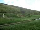
Greeves, T., 2020, Earthworks at Speke's Mill Mouth (Ground Photograph). SDV363842.
Earthwork remains visible at SS225236 which are presumed to be Speke's Mill. There are at least two buildings set below an obvious leat which looks as if it was widened to create two possible storage ponds. There are also adjacent terraced areas and a variety of other earthworks in the vicinity.
Watts, S., 2020, Speke's Mill (Ground Photograph). SDV363865.
Earthwork remains on a plateau above the cliffs at Speke's Mill Mouth. They are probably the remains of Speke's Mill. The line of a contour leat is visible along the hillside together with the potential site of a wheel pit and tailrace back to the stream just above the waterfall.
Sources / Further Reading
| SDV305931 | Report - non-specific: Bodman, M.. 1998. Water-Powered Sites in Devon. A4 Spiral Bound. 16. |
| |
| | |
| SDV325576 | Report - Interim: Bodman, M.. 2003. Watermills and Other Water-Powered Sites in Devon. A4 Spiral Bound. 148. |
| |
| | |
| SDV336179 | Cartographic: Ordnance Survey. 1880-1899. First Edition Ordnance 25 inch map. First Edition Ordnance Survey 25 inch Map. Map (Digital). |
| |
| | |
| SDV337544 | Article in Serial: Pearse Chope, R.. 1909. Notes of the Past. 126 - Corn and Fulling Mills. Hartland Chronicle. Digital. 4. |
| |
| | |
| SDV349431 | Cartographic: Devon County Council. 1838-1848. Tithe Mosaic, approximately 1838-1848. Digitised Tithe Map. Digital. |
| |
| | |
| SDV361462 | Aerial Photograph: Bluesky International Ltd/Getmapping PLC. 2015-2017. 2015-2017 Aerial Photographs. Bluesky International Ltd/Getmapping PLC. Photograph (Digital). [Mapped feature: #127001 ] |
| |
| | |
| SDV363842 | Ground Photograph: Greeves, T.. 2020. Earthworks at Speke's Mill Mouth. Digital. |
| |
| | |
| SDV363865 | Ground Photograph: Watts, S.. 2020. Speke's Mill. |
| |  |
| | Linked images:2 |
Associated Monuments
| MDV128920 | Related to: Leat to Speke's Mill, Hartland (Monument) |
| MDV102205 | Related to: Quarries at Speke's Mill Mouth, Hartland (Monument) |
Associated Finds: none recorded
Associated Events: none recorded
| Date Last Edited: | Sep 30 2020 11:09AM |
|---|
Search results generated by the HBSMR Gateway from exeGesIS SDM Ltd.