See important
guidance on the use of this record.
If you have any comments or new information about this record, please email us.
| HER Number: | MDV869 |
|---|
| Name: | Wharfs on the River Yeo above Braunton Bridge. |
|---|
Summary
Site of 19th century 19th and earlier 20th century wharfs on the River Yeo at Pilton.
Location
| Grid Reference: | SS 556 335 |
|---|
| Map Sheet: | SS53SE |
|---|
| Admin Area | Devon |
|---|
| Civil Parish | Barnstaple |
|---|
| District | North Devon |
|---|
| Ecclesiastical Parish | BARNSTAPLE |
|---|
| Ecclesiastical Parish | PILTON |
|---|
Protected Status: none recorded
Other References/Statuses
- Old DCC SMR Ref: SS53SE/39
Monument Type(s) and Dates
- QUAY (XIX - 1801 AD to 1900 AD (Between))
Full description
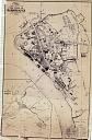
Wood, J., 1843, Plan of the Town of Barnstaple from Actual Survey (Cartographic). SDV91852.
Not shown on Wood's plan of 1843.
Ordnance Survey, 1904 - 1906, Second Edition Ordnance Survey 25 inch Map (Cartographic). SDV325644.
Wharf's marked on either side of the River Yeo just upstream of Braunton Bridge.
Bone, M., 1973, Barnstaple's Industrial Archaeology, 18 (Monograph). SDV78228.
River wharf. Pilton Wharf. Coal for Lynton, an important item of freight for the railway line, was unloaded here from ships which had passed through the swing bridge.
Hunter, J., 2003, Rawle Gammon and Baker Site, Rolle Quay, Barnstaple: Archaeological Desk Based Assessment, 8 (Report - Assessment). SDV339086.
Hughes, S. D. + Wheeler, J., 2006, An Archaeological Watching Brief at Rolle Quay, Barnstaple, 2 (Report - Watching Brief). SDV338542.
Site of a wharf for Barnstaple freight from the 17th - 19th centuries. A watching brief undertaken on 2006 established the location of the former River Yeo riverbank wall as well as a series of modern abutting make-up layers.
Sources / Further Reading
| SDV325644 | Cartographic: Ordnance Survey. 1904 - 1906. Second Edition Ordnance Survey 25 inch Map. Second Edition Ordnance Survey 25 inch Map. Map (Digital). [Mapped feature: #52970 ] |
| |
| | |
| SDV338542 | Report - Watching Brief: Hughes, S. D. + Wheeler, J.. 2006. An Archaeological Watching Brief at Rolle Quay, Barnstaple. Exeter Archaeology Report. 06.45. A4 Stapled + Digital. 2. |
| |
| | |
| SDV339086 | Report - Assessment: Hunter, J.. 2003. Rawle Gammon and Baker Site, Rolle Quay, Barnstaple: Archaeological Desk Based Assessment. CgMs Consulting Report. JH/3907. A4 Stapled + Digital. 8. |
| |
| | |
| SDV78228 | Monograph: Bone, M.. 1973. Barnstaple's Industrial Archaeology. Barnstaple's Industrial Archaeology. A5 Paperback. 18. |
| |
| | |
| SDV91852 | Cartographic: Wood, J.. 1843. Plan of the Town of Barnstaple from Actual Survey. Unknown. |
| |  |
| | Linked images:1 |
Associated Monuments: none recorded
Associated Finds: none recorded
Associated Events
- EDV4232 - Rolle Quay, Barnsatple
- EDV4279 - Rawle Gammon and Baker Site at Rolle Quay, Barnstaple
| Date Last Edited: | May 9 2013 4:12PM |
|---|
Search results generated by the HBSMR Gateway from exeGesIS SDM Ltd.