See important
guidance on the use of this record.
If you have any comments or new information about this record, please email us.
| HER Number: | MDV871 |
|---|
| Name: | Rolle's Quay, Barnstaple |
|---|
Summary
Rolle's Quay, on the north side of the River Yeo below Braunton Bridge, was once a busy landing place. In 1929 100, 000 tons of goods were handled. Commerial operations, however, declined by the mid 20th century and it now has no waterborne trading connections.
Location
| Grid Reference: | SS 554 334 |
|---|
| Map Sheet: | SS53SE |
|---|
| Admin Area | Devon |
|---|
| Civil Parish | Barnstaple |
|---|
| District | North Devon |
|---|
| Ecclesiastical Parish | BARNSTAPLE |
|---|
| Ecclesiastical Parish | PILTON |
|---|
Protected Status: none recorded
Other References/Statuses
- Old DCC SMR Ref: SS53SE/37
Monument Type(s) and Dates
- QUAY (XVIII to XXI - 1751 AD to 2009 AD (Between))
Full description
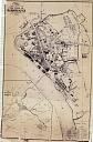
Wood, J., 1843, Plan of the Town of Barnstaple from Actual Survey (Cartographic). SDV91852.
Wood's plan of 1843 shows the earliest quay area adjacent to Braunton Bridge.
Ordnance Survey, 1880-1899, First Edition Ordnance 25 inch map (Cartographic). SDV336179.
Rolle's Quay marked on 1880s-1890s 25 inch Ordnance Survey map.
Ordnance Survey, 1904 - 1906, Second Edition Ordnance Survey 25 inch Map (Cartographic). SDV325644.
Rolle's Quay marked on 1904-1906 25 inch Ordnance Survey map, on the north side of the river Yeo, downstream of Braunton Bridge. A Pier is shown, a line of Mooring Posts and a Crane.
Bone, M., 1973, Barnstaple's Industrial Archaeology, 14 (Monograph). SDV78228.
Rolle's Quay is no longer used commercially. It was once a busy landing place and old 19th century photos show it packed with shipping. It was once served by a railway siding from the Barnstaple- Ilfracombe line. 100,000 tons of goods (mostly inward) were handled in 1929 when the quay was given to the corporation by Lord Clinton.
Chris Blandford Associates, 1997, Barnstaple Western Bypass and Urban Relief Road Stage 4. Environmental Assessment Phase A, 24 (Report - Assessment). SDV347381.
Commercial operations at Rolle's Quay had declined by mid 20th century and it now has no waterborne trading connections.
24/06/1981, Rolle's Quay, Barnstaple (Ground Photograph). SDV78170.
Devon County Council Conservation Section, Unknown, Rolle's Quay, Barnstaple, Film 395 (Ground Photograph). SDV78172.
Sources / Further Reading
| SDV325644 | Cartographic: Ordnance Survey. 1904 - 1906. Second Edition Ordnance Survey 25 inch Map. Second Edition Ordnance Survey 25 inch Map. Map (Digital). [Mapped feature: #108789 ] |
| |
| | |
| SDV336179 | Cartographic: Ordnance Survey. 1880-1899. First Edition Ordnance 25 inch map. First Edition Ordnance Survey 25 inch Map. Map (Digital). |
| |
| | |
| SDV347381 | Report - Assessment: Chris Blandford Associates. 1997. Barnstaple Western Bypass and Urban Relief Road Stage 4. Environmental Assessment Phase A. Chris Blandford Associates Report. Vol 2, Part 2. A4 Stapled + Digital. 24. |
| |
| | |
| SDV78170 | Ground Photograph: 24/06/1981. Rolle's Quay, Barnstaple. Slide. |
| |
| | |
| SDV78172 | Ground Photograph: Devon County Council Conservation Section. Unknown. Rolle's Quay, Barnstaple. Devon County Council Conservation Section Collection. Photograph (Paper). Film 395. |
| |
| | |
| SDV78228 | Monograph: Bone, M.. 1973. Barnstaple's Industrial Archaeology. Barnstaple's Industrial Archaeology. A5 Paperback. 14. |
| |
| | |
| SDV91852 | Cartographic: Wood, J.. 1843. Plan of the Town of Barnstaple from Actual Survey. Unknown. |
| |  |
| | Linked images:1 |
Associated Monuments: none recorded
Associated Finds: none recorded
Associated Events: none recorded
| Date Last Edited: | Feb 8 2013 9:05AM |
|---|
Search results generated by the HBSMR Gateway from exeGesIS SDM Ltd.