| Name: | Pillbox (destroyed) at Royal Ordnance Works, Enf. Naked Hall |
|---|
| SMR Number: | 10064 |
|---|
| Type of record: | Monument |
|---|
| Grid Reference: | TQ 380 988 |
|---|
| Map Sheet: | TQ39NE |
|---|
| Parish: | WALTHAM ABBEY, EPPING FOREST, ESSEX |
|---|
Summary
2500:1 map no.
Full description
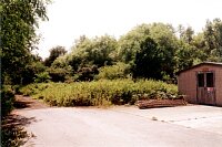
2500:1 map no. TQ 3898 dated 1971 (see source 1) shows a hexagonal building in the SE corner of the Royal Ordnance Works. It is of the right dimensions for a pillbox and is logically positioned close to the perimeter fence overlooking fields to the E. <1> However, if it was a pillbox, which appears probable, it has now been destroyed. There is a large quantity of old broken concrete in this area, mostly under scrub, and this suggests that this corner of the site was used for general dumping after the pillbox was demolished. One photo of site. <2>
<1> unknown, 1971, Reprographics Dept (Map). SEX31523.
<2> Nash, Fred, 1993, SMR, one frame (Photograph). SEX31432.
Monument Types
- PILLBOX (WWII, Modern - 1939 AD to 1945 AD)
Sources and further reading
| <1> | Map: unknown. 1971. Reprographics Dept. |
| <2> | Photograph: Nash, Fred. 1993. SMR. one frame. |
Images
 Pillbox (destroyed) at Royal Ordnance Works, Enf. Naked Hall Mill © Essex County Council | |
Search results generated by the HBSMR Gateway from exeGesIS SDM Ltd.