| Name: | Base, school field, Dovercourt |
|---|
| SMR Number: | 10669 |
|---|
| Type of record: | Monument |
|---|
| Grid Reference: | TM 239 310 |
|---|
| Map Sheet: | TM23SW |
|---|
| Parish: | HARWICH, TENDRING, ESSEX |
|---|
Summary
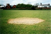
In the middle of the primary school field is a very clearly defined hexagonal patch of dead grass, 14' across, possibly covering the base of a former pillbox.
Full description
In the middle of the primary school field is a very clearly defined hexagonal patch of dead grass, 14' across, possibly covering the base of a former pillbox. This position is c.150 yards E of the Stanier Line anti-tank blocks. During WWII this area was allotments. However, both vertical and oblique aerial photographs taken during 1946-1949 show a small area of rough ground in the centre of the allotments. It is possible that the base, overgrown by the late 1940's, is the remains of a much earlier structure. <1 <2> <3> One photo of site. <4>
<1> RAF, 1946, 106G-UK 1492-4091, May 1946 (AP). SEX42449.
<2> RAF, 1948, CPE-UK 2534-5144 (AP). SEX42444.
<3> RAF, 1949, 540-194-0040 (AP). SEX42452.
<4> Nash, Fred, 1996, WWII defences, one frame (Photograph). SEX31461.
Monument Types
- PILLBOX (WWII, Modern - 1939 AD to 1945 AD)
Sources and further reading
| <1> | AP: RAF. 1946. 106G-UK 1492-4091. May 1946. |
| <2> | AP: RAF. 1948. CPE-UK 2534-5144. |
| <3> | AP: RAF. 1949. 540-194-0040. |
| <4> | Photograph: Nash, Fred. 1996. WWII defences. one frame. |
Images
 Base, school field, Dovercourt © Essex County Council | |
Search results generated by the HBSMR Gateway from exeGesIS SDM Ltd.