If you think this information is inaccurate please e-mail corrections to
Hertfordshire HER
.
| HHER Number: | 11150 |
|---|
| Type of record: | Building |
|---|
| Name: | 19TH CENTURY FARMSTEAD, STANDON LORDSHIP, STANDON |
|---|
Summary
Small group of mid 19th century farm buildings associated with the 1872 rebuilding of the manor house
Images
 No image caption available © Hertfordshire County Council |  No image caption available © Hertfordshire County Council |
 No image caption available © Hertfordshire County Council | |
Monument Types
- FARMSTEAD (Post Medieval - 1501 AD to 1900 AD)
Associated Events
- Hertfordshire timber farm buildings survey, 2002
Protected Status
- Listed Building (II) 161000: OUTHOUSE, FARM BUILDINGS AND WALL WITH BEEBOLES AT STANDON LORDSHIP WEST (45 METRES TO WEST OF HOUSE)
- SHINE: Standon Lordship, Medieval Manorial Site
- Area of Archaeological Significance 244
Full description
The farmstead at Standon Lordship appears on the 1839 tithe map <1> only as a single range SW of the house [12818] but at the SE corner of its own rectangular yard. As the house was in poor condition at this period it is quite possible that there had been older farm (or service) buildings here which had gone by 1839. By 1879 <2>, following the rebuilding of the house in 1872, the 1839 buildings had been replaced by new ones around the same yard, but without the appearance of a substantial planned farmstead. The layout included a rectangular barn to the west, an open-fronted shed along the north, and smaller pens or sheds along the east side of the yard, all adjoining a pair of new houses (now Lordship Cottages) at the SE corner. There was no change by 1898 <3> but by 1923 <4> the small pens had disappeared and the yard divided.
These farm buildings are Listed as indeed 19th century, adjoining a 16th century garden wall and outhouse [30297]. The 16th century outhouse is the small structure at the NE corner of the yard, adjoining the farm buildings. Part of the 19th century works was the continuation of the outhouse's north wall westwards as a screen wall to the forecourt of the house, in reused red brick and copying a Tudor arched opening for a door at the east end. It acts as the north boundary of the farmstead to a high gabled end for the five-bay west barn. The 19th century farm buildings are timber-framed and weatherboarded with slate roofs. The open-fronted shed along the north side of the yard, backing onto the red brick wall, is a 6-bay cattle shelter <6>.
2002 TIMBER-FRAMED FARM BUILDINGS SURVEY DESCRIPTION:
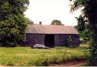
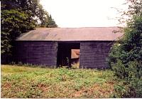
Two timber farm buildings: 1. Timber-framed and weather-boarded barn on a brick sill. Gable ended slated roof. Two opposing doorways in the east and west sides. Though being used as a garage it is unconverted. Situated at west side of site, with the open cart shed abutting its northeast corner. Potential for level 2 recording (photo 117, 118 and 119).
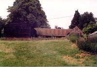
2. Timber posted open shed with a very old clay tile roof. Probably brick wall to north side. Situated along a track off the main road. Open shed abuts the barn on its east side at the north end and also abuts a brick building (also with a clay tile roof) at its west end. Potential for level 2 recording (photo 118 and 119) <5>.
RCHM (England), 1911, Inventory of the historical monuments in Hertfordshire, - p208 (Bibliographic reference). SHT9222.
<1> Tithe map and award, Standon, 1839 (map) (Cartographic material). SHT1377.
<2> OS 25 inch map, 1st edition, 1879 (Cartographic material). SHT8116.
<3> OS 25 inch map, 2nd edition (1897-1901), Sheet XXII-6 (1897) (Cartographic material). SHT8113.
<4> OS 25 inch map, 3rd edition (1913-1925), 1923 (Cartographic material). SHT5271.
<5> Wilcox, Sallianne, 2002, Hertfordshire timber farm buildings survey: East Herts District: Aspenden, Ardeley, Cottered, Great Munden, Little Munden, Standon, Farm 63, site visit 3/7/02 (Unpublished document). SHT16687.
<6> Listed Buildings description (Digital archive). SHT6690.
Sources and further reading
| --- | Bibliographic reference: RCHM (England). 1911. Inventory of the historical monuments in Hertfordshire. - p208. |
| <1> | Cartographic material: Tithe map and award. Standon, 1839 (map). |
| <2> | Cartographic material: OS 25 inch map, 1st edition. 1879. |
| <3> | Cartographic material: OS 25 inch map, 2nd edition (1897-1901). Sheet XXII-6 (1897). |
| <4> | Cartographic material: OS 25 inch map, 3rd edition (1913-1925). 1923. |
| <5> | Unpublished document: Wilcox, Sallianne. 2002. Hertfordshire timber farm buildings survey: East Herts District: Aspenden, Ardeley, Cottered, Great Munden, Little Munden, Standon. Farm 63, site visit 3/7/02. |
| <6> | Digital archive: Listed Buildings description. |
Search results generated by the HBSMR Gateway from exeGesIS SDM Ltd.