If you think this information is inaccurate please e-mail corrections to
Hertfordshire HER
.
| HHER Number: | 12201 |
|---|
| Type of record: | Building |
|---|
| Name: | WESTFIELD FARM, PIG'S GREEN, LITTLE HADHAM |
|---|
Summary
Post-medieval farmstead at Westfield, with buildings on both sides of the road until the mid 20th century
Images
 No image caption available © Hertfordshire County Council | 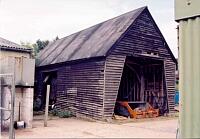 No image caption available © Hertfordshire County Council |
 No image caption available © Hertfordshire County Council | 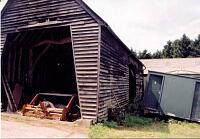 No image caption available © Hertfordshire County Council |
 No image caption available © Hertfordshire County Council | |
Monument Types
- FARMSTEAD (Post Medieval - 1501 AD to 1900 AD)
Associated Events
- Hertfordshire timber farm buildings survey, 2002
Protected Status
- Listed Building (II) 395452: BARN AT WESTFIELD FARM 65 METRES NORTH NORTH EAST OF WESTFIELD
- Listed Building (II) 1/7
- Sensitivity Map: westfield farm
Full description
Westfield Farm is now entirely on the north side of the road, but is shown on the 1844 tithe map <1> as a large farmstead with ranges of buildings on both sides, with the house itself [12199] (with medieval origins) at the south end. In essence the lane ran through the farmyard, past a broadening of the roadway along the edge of a pond [6404]. There were no other buildings along the north side of the lane (the house called Westfield Bury was built in the 20th century). The later 19th century OS maps <2, 3> show the farmstead in detail, with barns and sheds around a compartmented yard and a gate in the lane just to the east. No change is shown on the 1921 map <4>. In the mid 20th century the farmstead was separated from the house, the gate across the roadway removed, and the farm buildings on the south side of the lane demolished leaving only a granary [12200]. Large new farm buildings have been put up beyond the remnants of the post-medieval farmstead.
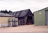
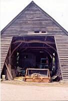
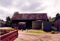
What survives is a timber-framed and weatherboarded barn which dates to the 18th-19th century. It is five bays long with opposed double doors in the centre bay. The door posts on the south side are 'carefully inscribed' TC 1830 and IC 1830, which presumably date a renovation <5>. The granary [12200] near the house has a similar inscription.
2002 TIMBER FARM BUILDINGS SURVEY DESCRIPTION:
18th century timber-framed barn, weatherboarded on brick sill. Gabled corrugated iron roof. Opposing doorways in N and S face <6>.
<1> Tithe map and award, Little Hadham, 1844 (map) (Cartographic material). SHT1377.
<2> OS 25 inch map, 1st edition, 1879 (Cartographic material). SHT8116.
<3> OS 25 inch map, 2nd edition (1897-1901), 1897 (Cartographic material). SHT8113.
<4> OS 25 inch map, 3rd edition (1913-1925), 1921 (Cartographic material). SHT5271.
<5> Listed Buildings description (Digital archive). SHT6690.
<6> Wilcox, Sallianne, 2002, Hertfordshire timber farm buildings survey: East Herts District: Little Hadham, Much Hadham, Thundridge, Buntingford, Farm 79, site visit 4/07/02 (Unpublished document). SHT16688.
Sources and further reading
| <1> | Cartographic material: Tithe map and award. Little Hadham, 1844 (map). |
| <2> | Cartographic material: OS 25 inch map, 1st edition. 1879. |
| <3> | Cartographic material: OS 25 inch map, 2nd edition (1897-1901). 1897. |
| <4> | Cartographic material: OS 25 inch map, 3rd edition (1913-1925). 1921. |
| <5> | Digital archive: Listed Buildings description. |
| <6> | Unpublished document: Wilcox, Sallianne. 2002. Hertfordshire timber farm buildings survey: East Herts District: Little Hadham, Much Hadham, Thundridge, Buntingford. Farm 79, site visit 4/07/02. |
Related records
| 12200 | Parent of: POST-MEDIEVAL GRANARY AT WESTFIELD, PIG'S GREEN, LITTLE HADHAM (Building) |
| 12199 | Related to: WESTFIELD, PIG'S GREEN, LITTLE HADHAM (Building) |
Search results generated by the HBSMR Gateway from exeGesIS SDM Ltd.