If you think this information is inaccurate please e-mail corrections to
Hertfordshire HER
.
| HHER Number: | 12664 |
|---|
| Type of record: | Building |
|---|
| Name: | THE RYE HOUSE PUBLIC HOUSE, RYE ROAD, HODDESDON |
|---|
Summary
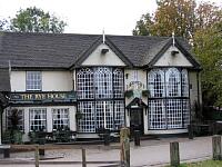
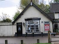
19th century public house ornamented by Henry Teale c.1870 for his commercial pleasure gardens
Images
 No image caption available © Hertfordshire County Council |  No image caption available © Hertfordshire County Council |
| Grid Reference: | TL 385 098 |
|---|
| Map Sheet: | TL30NE |
|---|
| Parish: | Broxbourne (Non Civil Parish), Broxbourne, Hertfordshire |
|---|
| Map: | Show location on Streetmap |
|---|
Monument Types
- PLEASURE GARDEN (Post Medieval - 1501 AD to 1900 AD)
- PUBLIC HOUSE (Post Medieval - 1501 AD to 1900 AD)
Protected Status
- Listed Building (II) 15/5
- Listed Building (II) 355974: THE RYE HOUSE PUBLIC HOUSE
- Area of Archaeological Significance CA
Full description
An early 19th century building (possibly of earlier origin), two storeys, roughcast with gabled red tile roofs. The single-storey east wing was added c.1868; the rest was largely rebuilt in 1980 incorporating elements of the old façade. The E wing projects greatly and has a tarred brick plinth, a shallow bow window (renewed), small lean-to porch, pierced and faceted Gothic bargeboard, a terracotta winged dragon on the ridge, and a gabled square bay window with similar bargeboard on the W side. Flanking the central hooded door are very large early 19th century bow fronted 2-storey cast iron Gothic windows from a house in Cheshunt. They were added to the then Kings Arms Inn by Henry Teale (1806-76) c.1870 when he was developing Rye House as a pleasure garden for Londoners. The projecting bargeboarded gables over each window have identical 19th century large circular plaques with a naturalistic scene in relief of tributes being offered to Britannia with lion couchant. At the rear is a 2 storey early 19th century block, white weatherboarded with a slate roof. 16th and 17th century stained glass has been reset in the heads of the front bow windows <1>.
The building is shown on the 1840 tithe map <2> as the Kings Arms, and had a mass of small outbuildings. The plot was bounded on the south side by the river Lea, and on the north and east sides by a ditch leading from Rye House moat to the river. A similar complex is shown here on the 1822 map <3>.
It is shown on the 1880 OS map <4> as one complex with the remains of Rye House, in the heyday of the pleasure gardens. Rye House railway station [5545] brought visitors who only had to cross Rye Bridge [5911] to reach the public house. Behind the pub were gardens including a maze; opposite on the riverbank was a large boathouse, and behind this were the gates into the gardens enclosed by the moat [61]. The gateposts [12255] are chimneys salvaged by Teale from the remains of the 15th century house (see [285]) and repositioned along with other elements [12256, 12257] around the gardens with large glasshouses, and extensive buildings beyond the north corner of the moat. The 1898 map <5> shows the same layout, with the name Rye House Hotel.
<1> Listed Buildings description (Digital archive). SHT6690.
<2> Tithe map and award, Stanstead Abbots, 1840 (map) (Cartographic material). SHT1377.
<3> Bryant, A, 1822, Map of the county of Hertford from actual survey in the years 1820 and 1821 (Cartographic material). SHT2160.
<4> OS 25 inch map, 1st edition, 1880 (Cartographic material). SHT8116.
<5> OS 25 inch map, 2nd edition (1897-1901), 1898 (Cartographic material). SHT8113.
Sources and further reading
| <1> | Digital archive: Listed Buildings description. |
| <2> | Cartographic material: Tithe map and award. Stanstead Abbots, 1840 (map). |
| <3> | Cartographic material: Bryant, A. 1822. Map of the county of Hertford from actual survey in the years 1820 and 1821. |
| <4> | Cartographic material: OS 25 inch map, 1st edition. 1880. |
| <5> | Cartographic material: OS 25 inch map, 2nd edition (1897-1901). 1898. |
Search results generated by the HBSMR Gateway from exeGesIS SDM Ltd.