If you think this information is inaccurate please e-mail corrections to
Hertfordshire HER
.
| HHER Number: | 1927 |
|---|
| Type of record: | Monument |
|---|
| Name: | MOATED SITE, PIRTON GRANGE, SHILLINGTON ROAD, PIRTON |
|---|
Summary
Medieval homestead moat
Images
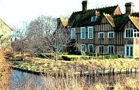
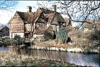
 No image caption available © Hertfordshire County Council |  No image caption available © Hertfordshire County Council |
Monument Types
- MOAT (Medieval to Post Medieval - 1066 AD to 1900 AD)
Protected Status
- Scheduled Ancient Monument 11568: PIRTON GRANGE MOATED ENCLOSURE AND ASSOCIATED SETTLING POND, PIRTON
- SHINE: Pirton Grange, Medieval Moated Site
- Area of Archaeological Significance
Full description
A large rectangular, waterfilled moat, with fine gatehouse [11188] over the moat and a complex of medieval and post-medieval buildings on the platform [11187, 11189]. The moat is 70m E-W x 50m N-S and is fed by a leat to the south. Visually it is one of the most impressive moated sites in Herts. Around 50 years ago the moat was 4.5m deep; today it is only 30cm deep <1>.
In 1986 the owner knew of several dredgings of the moat; one 'a hundred years ago' when notched timbers of what was thought to be a drawbridge were revealed; in 1931, and during WWII when the currents that carried away the silt were disturbed. The banks were apparently revetted on the southern outer side. The platform is at a higher level than the surrounding land <1>.
The fishpond [4706] 40m south of the moat dates to the 19th century.
Postcard (Photograph). SHT9309.
RCHM (England), 1911, Inventory of the historical monuments in Hertfordshire, - p162 (Bibliographic reference). SHT9222.
Air Photo Services, 1995, House and moated site, Pirton Grange, PNO 8267 (Aerial Photograph). SHT15506.
Air Photo Services, 1995, House and moated site, Pirton Grange, PNO 8268 (Aerial Photograph). SHT15507.
Air Photo Services, 1995, House and moated site, Pirton Grange, PNO 8270 (Aerial Photograph). SHT15509.
Air Photo Services, 1995, House and moated site, Pirton Grange, PNO 8273 (Aerial Photograph). SHT15512.
Air Photo Services, 1995, House and moated site, Pirton Grange, PNO 8274 (Aerial Photograph). SHT15513.
<1> Cave-Penny, Helena (HCC) site report, 21.1.86 (Unpublished document). SHT4214.
<2> OS Records (Index). SHT8223.
Sources and further reading
| --- | Aerial Photograph: Air Photo Services. 1995. House and moated site, Pirton Grange. PNO 8267. |
| --- | Aerial Photograph: Air Photo Services. 1995. House and moated site, Pirton Grange. PNO 8268. |
| --- | Aerial Photograph: Air Photo Services. 1995. House and moated site, Pirton Grange. PNO 8270. |
| --- | Aerial Photograph: Air Photo Services. 1995. House and moated site, Pirton Grange. PNO 8273. |
| --- | Aerial Photograph: Air Photo Services. 1995. House and moated site, Pirton Grange. PNO 8274. |
| --- | Bibliographic reference: RCHM (England). 1911. Inventory of the historical monuments in Hertfordshire. - p162. |
| --- | Photograph: Postcard. |
| <1> | Unpublished document: Cave-Penny, Helena (HCC) site report. 21.1.86. |
| <2> | Index: OS Records. |
Search results generated by the HBSMR Gateway from exeGesIS SDM Ltd.