If you think this information is inaccurate please e-mail corrections to
Hertfordshire HER
.
| HHER Number: | 34 |
|---|
| Type of record: | Monument |
|---|
| Name: | GREAT WYMONDLEY CASTLE, GREAT WYMONDLEY |
|---|
Summary
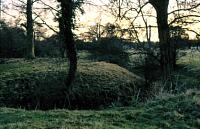
Earthwork motte and bailey, with other earthworks to the east
Images
 No image caption available © Hertfordshire County Council | |
Monument Types
- ENCLOSURE (Unknown date)
- MOTTE AND BAILEY (Medieval - 1066 AD to 1500 AD)
Associated Events
- Monitoring at 14 Graveley Road, Great Wymondley, 2012 (Ref: AS1520)
Protected Status
- SHINE: Wymondley Medieval Castle & Romano-British settlement
- Scheduled Ancient Monument 20637: GREAT WYMONDLEY CASTLE: A MOTTE AND BAILEY CASTLE AND ASSOCIATED MANORIAL ENCLOSURE 20M EAST OF ST MARY'S CHURCH, GREAT WYMONDLEY
- Area of Archaeological Significance 79
Full description
A small, moated motte and bailey inserted into the SW corner of a larger, roughly rectangular earthwork. This earthwork may be medieval or even Roman in date. There are also further earthwork enclosures which could be medieval, and manorial in origin <1>.
The earthworks comprise a motte and bailey, with, attached on the east, enclosures which are probably manorial in origin. The motte is covered with unmanaged scrubby vegetation, the field to the east under pasture. There are low earthworks in this field which may represent further subdivisions of the field and a low backscarp to the bailey ditch. The relationship between the castle and the two subrectangular enclosures is unclear, but their sharp form may indicate they are later than the castle <5>.
Only topsoil and made ground above clay natural was revealed at the north end of the bailey in 2012 <6>.
HCC (General/Archaeology), Earthworks and enclosure associated with Great Wymondley Castle & St Mary's Church, PNO 20269 (Photograph). SHT16489.
HCC (General/Archaeology), Earthworks and enclosure associated with Great Wymondley Castle & St Mary's Church, PNO 20270 (Photograph). SHT16490.
HCC (General/Archaeology), Earthworks associated with Great Wymondley Castle & St Mary's Church, PNO 20266 (Photograph). SHT16486.
HCC (General/Archaeology), Earthworks associated with Great Wymondley Castle & St Mary's Church, PNO 20267 (Photograph). SHT16487.
HCC (General/Archaeology), Earthworks associated with Great Wymondley Castle & St Mary's Church, PNO 20268 (Photograph). SHT16488.
RCHM (England), 1911, Inventory of the historical monuments in Hertfordshire, - p105 (Bibliographic reference). SHT9222.
Holt, Janet, 2006, What features and sites in the early landscape could have influenced the later siting of a Norman motte and bailey castle with medieval church in close proximity? (R1780), Photos (Unpublished document). SHT16872.
<1> OS Records (Index). SHT8223.
<2> Cave-Penny, Helena (HCC) site report, 22.1.86 (Unpublished document). SHT4214.
<3> Page, W (ed.), 1912, VCH Hertfordshire vol.3, - p119 (Bibliographic reference). SHT2329.
<4> Chalkley Gould, I, 1905, Wymondley Castle; Trans East Herts Archaeol Soc 3/1, 10-11 (Article in serial). SHT5811.
<5> National Monuments Record, NMR Monument Report (Hertfordshire), RNO 2347 p44 (Unpublished document). SHT9440.
<6> Pozorski, Zbigniew, 2012, 14 Graveley Road, Great Wymondley, Hertfordshire: archaeological monitoring and recording, RNO 3707 (Report). SHT17907.
Sources and further reading
| --- | Photograph: HCC (General/Archaeology). Earthworks associated with Great Wymondley Castle & St Mary's Church. PNO 20266. |
| --- | Photograph: HCC (General/Archaeology). Earthworks associated with Great Wymondley Castle & St Mary's Church. PNO 20267. |
| --- | Photograph: HCC (General/Archaeology). Earthworks associated with Great Wymondley Castle & St Mary's Church. PNO 20268. |
| --- | Photograph: HCC (General/Archaeology). Earthworks and enclosure associated with Great Wymondley Castle & St Mary's Church. PNO 20269. |
| --- | Photograph: HCC (General/Archaeology). Earthworks and enclosure associated with Great Wymondley Castle & St Mary's Church. PNO 20270. |
| --- | Unpublished document: Holt, Janet. 2006. What features and sites in the early landscape could have influenced the later siting of a Norman motte and bailey castle with medieval church in close proximity? (R1780). Photos. |
| --- | Bibliographic reference: RCHM (England). 1911. Inventory of the historical monuments in Hertfordshire. - p105. |
| <1> | Index: OS Records. |
| <2> | Unpublished document: Cave-Penny, Helena (HCC) site report. 22.1.86. |
| <3> | Bibliographic reference: Page, W (ed.). 1912. VCH Hertfordshire vol.3. - p119. |
| <4> | Article in serial: Chalkley Gould, I. 1905. Wymondley Castle; Trans East Herts Archaeol Soc 3/1, 10-11. |
| <5> | Unpublished document: National Monuments Record. NMR Monument Report (Hertfordshire). RNO 2347 p44. |
| <6> | Report: Pozorski, Zbigniew. 2012. 14 Graveley Road, Great Wymondley, Hertfordshire: archaeological monitoring and recording. watching brief. RNO 3707. |
Search results generated by the HBSMR Gateway from exeGesIS SDM Ltd.