If you think this information is inaccurate please e-mail corrections to
Hertfordshire HER
.
| HHER Number: | 391 |
|---|
| Type of record: | Monument |
|---|
| Name: | MOATED SITE, ARDELEY BURY, ARDELEY |
|---|
Summary
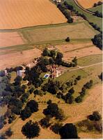
Substantial moat and earthworks, perhaps originally a motte, and possibly altered in early 19th century landscaping
Images
 No image caption available © Hertfordshire County Council | |
Monument Types
- BANK (EARTHWORK) (Historic: period uncertain - 410 AD to 1900 AD)
- MOAT (Medieval - 1066 AD to 1500 AD)
- MOTTE? (Medieval - 1066 AD to 1500 AD)
Protected Status
- Scheduled Ancient Monument 20624: ARDELEY BURY MOATED SITE AND FISHPOND
- SHINE: Ardeley Bury, medieval moated site, earthworks and parkland
Full description
The moat is complete though dry save for the south part of the NE arm which has been filled in <1>. Large area enclosed by ditch with large bank on W side. A substantial bank and ditch on this side suggest the work might have been a motte and bailey <2>, 'not unlike that at Walkern Bury in the adjacent parish. Sir Henry Chauncy described it as "moated round, with a Mount within the moat, and a Garden-place within the Mount, which seems to be a Mark of a Fortification in the time of the Danish or Baron's Wars"' <3>. Extensive landscaping (including the large lake in front of the house) took place when the house [4211] was altered in 1820, and earlier earthworks may have been altered then <2>. The moat is shown in detail on the 1878 OS map, when it was water-filled apart from the eastern corner, and crossed by footbridges in the gardens.
The manor belonged to the Canons of St Paul's Cathedral, from before 1066 until 1808; a motte may be unlikely. Although it was leased out from 1141 the tenants were often canons. But it is possible that some sort of defence was needed here; this was an area with plenty of earthwork 'castles' <5>.
CUCAP, Ardeley Bury moated site, and ridge & furrow, PNO 3942 (Aerial Photograph). SHT15214.
Essex County Council, Moated site, Ardeley Bury, Ardeley, PNO 8919 (Aerial Photograph). SHT16158.
RCHM (England), 1911, Inventory of the historical monuments in Hertfordshire, - p36 (Bibliographic reference). SHT9222.
<1> OS Records (Index). SHT8223.
<2> MWT (HCC) site visit, 18.3.87 (Unpublished document). SHT7226.
<3> Martin, Edward, & Satchell, Max, 2008, Whear most Inclosures be. East Anglian fields: history, morphology and management, - p160 (Bibliographic reference). SHT2573.
<4> OS 25 inch map, 1st edition, 1878 (Cartographic material). SHT8116.
<5> Information from Derek Renn, Letter, Sept 2011 (Unpublished document). SHT1851.
Sources and further reading
| --- | Aerial Photograph: CUCAP. Ardeley Bury moated site, and ridge & furrow. PNO 3942. |
| --- | Aerial Photograph: Essex County Council. Moated site, Ardeley Bury, Ardeley. PNO 8919. |
| --- | Bibliographic reference: RCHM (England). 1911. Inventory of the historical monuments in Hertfordshire. - p36. |
| <1> | Index: OS Records. |
| <2> | Unpublished document: MWT (HCC) site visit. 18.3.87. |
| <3> | Bibliographic reference: Martin, Edward, & Satchell, Max. 2008. Whear most Inclosures be. East Anglian fields: history, morphology and management. - p160. |
| <4> | Cartographic material: OS 25 inch map, 1st edition. 1878. |
| <5> | Unpublished document: Information from Derek Renn. Letter, Sept 2011. |
Related records
| 9552 | Part of: DEER PARK AND LANDSCAPED GARDENS, ARDELEY BURY, ARDELEY (Landscape) |
| 4211 | Related to: MANOR HOUSE, ARDELEY BURY, ARDELEY (Building) |
Search results generated by the HBSMR Gateway from exeGesIS SDM Ltd.