If you think this information is inaccurate please e-mail corrections to
Hertfordshire HER
.
| HHER Number: | 5911 |
|---|
| Type of record: | Building |
|---|
| Name: | RYE BRIDGE, RYE ROAD, HODDESDON |
|---|
Summary
Bridge of long ancestry carrying the road over the river Lea
Images
 No image caption available © Hertfordshire County Council | |
| Grid Reference: | TL 385 098 |
|---|
| Map Sheet: | TL30NE |
|---|
| Parish: | Broxbourne (Non Civil Parish), Broxbourne, Hertfordshire |
|---|
| Map: | Show location on Streetmap |
|---|
Monument Types
- BRIDGE (Post Medieval - 1501 AD to 1900 AD)
Full description
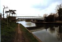
Road bridge over River Lea, concrete piers and reinforced concrete girder with metal panelled parapet, painted white. Has a service pipe on S side <1>.
This is Rye Bridge, the latest in a series of bridges carrying the road over the river Lea. In the 15th century Sir Andrew Ogard of Rye House [61, 285] maintained a causeway across the marshy ground above the confluence of the rivers Lea and Stort, facilitating what became a highway from London to East Anglia. The bridge is shown on the 1840 tithe map <2> with walls, apparently of brick. It is named Rye Bridge on the 1880 OS map <3>.
<1> Wild, Sarah (HCC), 1994, Survey, 20.4.94 (Unpublished document). SHT9650.
<2> Tithe map and award, Stanstead Abbots, 1840 (map) (Cartographic material). SHT1377.
<3> OS 25 inch map, 1st edition, 1880 (Cartographic material). SHT8116.
Sources and further reading
| <1> | Unpublished document: Wild, Sarah (HCC). 1994. Survey. 20.4.94. |
| <2> | Cartographic material: Tithe map and award. Stanstead Abbots, 1840 (map). |
| <3> | Cartographic material: OS 25 inch map, 1st edition. 1880. |
Search results generated by the HBSMR Gateway from exeGesIS SDM Ltd.