If you have any feedback or new information about this record, please email the Southampton HER (her@southampton.gov.uk).
Data derived from Heritage Gateway will not be acceptable for any use associated with development proposals and other planning matters.
For important guidance on the use of this record, please click
here
. © Southampton City Council
| HER Number: | MSH503 |
|---|
| Type of Record: | Monument |
|---|
| Name: | Town Defences - town wall (demolished) between Southampton Castle and Biddles Gate |
|---|
| Grid Reference: | SU 4181 1138 |
|---|
| Map: | Show location on Streetmap |
|---|
Summary
The town wall between Biddles Gate and the castle enclosed an area that jutted out from the general line of the western town wall and castle wall. From Biddles Gate the wall ran westwards for some distance before turning roughly northwards and continuing to a tower on the walls, and then ran north-eastwards to a tower at the south end of the west castle wall. The purpose of this layout was to provide cross fire cover to Biddles Gate and southwards to the quayside along the Arcades. Most of the wall was on the shore until the waterfront was extended in the 19th century. (It is possible that a large gate tower faced southwards down the quay in this area. The evidence for this is insubstantial but is discussed on the Biddles Gate record - MSH2285.) In 1454 there was a tower along this stretch of wall, probably the tower shown as rectangular on the 1870 map (MSH722). In 1801/5, Englefield mentioned another tower (MSH50), said to be square, to the south of this, at the end of the east-west wall from Biddles Gate, although this appears to be the only reference to a tower here.
The town wall was finally demolished in 1898/1899 when the area was completely cleared to create a single roadway along the walls - Western Esplanade. Parts of it had probably been demolished by the late 18th century, and in 1883 it is described as low and fragmentary. However the line of the wall appears to have been preserved in the layout of the area shown on 19th century maps.
In 1973/4, an archaeological excavation south of the castle site (SOU 123 Area B) revealed a short length of the town wall footings adjoining the west end of the castle garderobe (MSH564), on an alignment that agreed with 19th century maps. This was dated to “late in the medieval period”. A north-south wall (MSH3157) was also found, perhaps an earlier town wall that ran from the castle straight to Biddles Gate. Dump deposits showed that the area had been reclaimed from the shore in the early 14th century, presumably prior to the construction of the first defences.
This part of the town wall may have been built in the late 14th century when the town wall adjacent to West Quay was built; this would just fall within the date range suggested by the SOU 123 work. It was almost certainly in place in 1454 when the terrier was compiled, and is shown on the 1611 map.
Protected Status: None recorded
Other References/Statuses
- Old Southampton SMR No/Backup file: SU 4111 SE 66
Monument Type(s):
Full description
Records for the town defences are currently being enhanced and it is intended that further details will be added to this description at a later date. (SCC HER 8/12/09)
---------------------------
SOU 123 (UBS II) (excavations in Upper Bugle Street and the Southampton Castle Site in 1973/1974):
[1]: The deep footings of a short length of Town Wall were found, adjoining the "mural tower" (=Garderobe Tower - IP) and aligned roughly NNE/SSW (see figure 9). Dating evidence suggesting a late medieval date. [Another, possibly earlier, north/south stone wall footing was found to the east, which adjoined the Garderobe (see separate record) and continued the line of the west castle wall.] In the early 20th century, the ground levels had ben considerably reduced and the above-ground part of the medieval Town Wall removed.
IP 29/6/04: See separate record for other results from SOU 123.
Sources / Further Reading
| [1] | SSH925 - Serial: SARC. 1974?. Southampton Archaeological Research Committee Annual Report for 1973-4. pp 13 - 17, figure 9 (p 26). |
Associated Finds: None recorded
Associated Events
- ESH123 - Excavations in Upper Bugle Street and the Southampton Castle Site in 1973/1974 (UBS II) (Ref: SOU 123)
Related records
| MSH14 | Child of: Town Defences - town wall, towers and gates |
| MSH814 | Peer (All Groups): Biddlesgate Court in Upper Bugle Street - All Below-Ground Evidence |
| MSH816 | Peer (All Groups): Biddlesgate Court in Upper Bugle Street - Large Ditch |
Associated Links: None recorded
Images
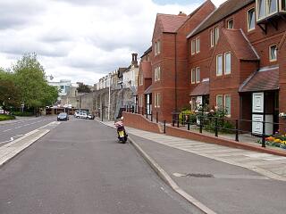
 Area of former projecting mass of town wall north of Biddles Gate, now under Western Esplanade (town wall to north), 21.6.09, © I Peckham | |
If you have any feedback or new information about this record, please email the Southampton HER (her@southampton.gov.uk).
Search results generated by the HBSMR Gateway from exeGesIS SDM Ltd.