If you have any feedback or new information about this record, please email the Southampton HER (her@southampton.gov.uk).
Data derived from Heritage Gateway will not be acceptable for any use associated with development proposals and other planning matters.
For important guidance on the use of this record, please click
here
. © Southampton City Council
| HER Number: | MSH743 |
|---|
| Type of Record: | Monument |
|---|
| Name: | Southampton Castle - Castle Hall |
|---|
| Grid Reference: | SU 4184 1142 |
|---|
| Map: | Show location on Streetmap |
|---|
Summary
Castle Hall was a two-storey, stone-built house in the south-west corner of Southampton Castle. It was built in the early-to-mid 12th century, perhaps even in the late 11th century. It was built at the base of low natural cliff and the west wall faced onto Castle Quay. The remains of the building were discovered during archaeological excavations between 1973 and 1983 (SOU 123 Area A and SOU 116). Perhaps in the 13th century, a vault was inserted into the ground floor. In the late 14th century two openings in the west wall were blocked and keyhole gunports inserted; the wall then became part of the curtain wall of the castle (see MSH553). The gunports were modified in the 16th/17th century. From the 16th century onwards the building was partially demolished, collapsed and infilled.
Further archaeological work took place at Castle Hall in 2006/7 (SOU 1400); four trenches were excavated inside the building and a watching brief carried out on two trenches in the pavement to the west. Further inconclusive dating evidence was found for the construction of the hall and vault; this did not contradict the earlier evidence. A possible medieval well was found inside the building. The evidence perhaps suggested that the blocking of the southern opening was somewhat later than previously suggested.
Protected Status
- Listed Building (I) 1340005: TOWN WALLS: SECTION OF WALL RUNNING WEST FROM BARGATE TO ARUNDEL TOWER AND THEN SOUTH TO POINT JUST SOUTH OF CASTLE WATER GATE. IT INCLUDES ARUNDEL TOWER, CATCHCOLD TOWER, GARDEROBE TOWER, THE 40 STEPS, CASTLE WATER GATE & CASTLE VAULT & THE TOWN WALLS
- Scheduled Monument 1001889: Castle (part of), Western Esplanade
Other References/Statuses
- HER backup file (new series): SOU 123 (digital only), etc
- Old Southampton SMR No/Backup file: SU 4111 SE 66 also SU 4111 SE 67
Monument Type(s):
- BANQUETING HOUSE (In use, Medieval - 1066 AD? to 1539 AD)
- CASTLE (Medieval to Post Medieval - 1066 AD? to 1618 AD)
- FLOOR (Medieval - 1066 AD? to 1539 AD)
- HALL HOUSE (Built, Medieval - 1066 AD? to 1155 AD)
- HALL HOUSE (In use, Medieval - 1066 AD? to 1539 AD)
- HALL HOUSE (Altered (vault inserted), Medieval - 1200 AD to 1299 AD)
- VAULT (Built, Medieval - 1200 AD to 1299 AD)
- WELL? (Medieval - 1250 AD? to 1539 AD?)
- HALL HOUSE (altered, Medieval - 1378 AD to 1379 AD)
- FLOOR (Post Medieval - 1540 AD to 1800 AD)
Full description
[1]: Extract from Listed Building Description. TOWN WALLS. Section of wall running west from Bargate to Arundel Tower and then south to point just south of Castle Water Gate. It includes Arundel Tower, Catchcold Tower, Garderobe Tower, The 40 Steps, Castle Water Gate and Castle Vault (formerly listed as Section of Town Wall running from the point of junction with the Castle Wall just north of Simnel Street to its eastern termination just west of Bargate). Grade I. (List description not included here.)
(SCC HER 27/10/09: Note that Castle Hall is not mentioned in the list name or in the associated description. The west wall of Castle Hall forms part of the town wall, so is listed. The rest of Castle Hall is not listed. It is all scheduled however.)
----------------------------------
See Parent Record MSH23 for a summary of the documentary and excavation evidence for Southampton Castle, a discussion of the development of the Castle derived largely from [3], and a full list of sources. The evidence below is in chronological order.
----------------------------------
[10][11]: Englefield, 1801/5. In the description of the circuit of the "town wall", refers to "traces of loops and small windows, which lighted a large vault".
(The "large vault" is clearly Castle Vault, which he later describes, although probably also refers to the openings in the wall of Castle Hall. Castle Hall is not otherwise mentioned by Englefield. SCC HER)
[13]: Davies, 1883. Describes the exterior of the west wall of Castle Hall (unnamed).
[12]: VCH 1908. (Largely derived from [13].) West wall by Castle Hall.
[3] (p 117): By the mid 19th century Castle Hall was completely filled with rubbish, its roof and walls having been demolished at some time in the 17th or 18th century.
----------------------------------
SOU 123 Area A (UBS II) and part of SOU 116 (excavations and watching briefs in 1973/1974 and after):
[4] in [3]: Castle Hall was discovered during this work. The northern part of the vault floor was excavated.
_ ?Late 11th/early 12th century (Phase 1A): A two storey stone building, now known as the Castle Hall, with passage to north (Watergate Passage), doorways, a stone spiral staircase in the SW corner, a stone-lined feature in the NW corner of the Hall; a stone-lined garderobe in SE corner of Hall. The west wall of Castle Hall formed the west wall of the castle, and the south wall was a continuation of the south bailey wall. The west wall is 1m thick on average (note this is much thinner than the west wall of Castle Vault). The east wall of the hall had been built at the base of a natural cliff, which had been partially cut back to create a construction trench. Only the upper of the two storeys would have been visible from inside the castle. Built of limestone and mortar (more in source). Castle Hall, Garderobe 1 (at SE corner) and south bailey wall represent a single period of construction. It would probably have opened onto Castle Quay to the west, although there is no direct evidence of this (the form of the surviving blocked openings is later). At first floor level in the west wall is evidence of two or three windows, now blocked. These may be referred to be Englefield (1805, 27). (See source for description of Castle Hall.) (On page 114 of [3], it is stated that Castle Hall is an early to mid 12th century structure.)
_ 13th century (Phase 2): A barrel vault was inserted into Castle Hall. The vaulting had collapsed, although much of it survived intact on top of rubbish deposits that had been dumped in the vault. The dating of this feature is uncertain. The character of the masonry might suggest a 13th century date. Some excavated evidence might support a 13th century date. A 13th century date may also be suggested from the documentary evidence, although not proven (see parent record MSH23). (See SOU 1400 below for a reinterpretation of the evidence for the vault insertion.)
_ Late 14th century (Phase 4): two early openings in the west wall of Castle Hall were blocked and keyhole gunports inserted. Documentary evidence suggests this phase dates to 1378-88.
_ 16th to 18th century: 16th/17th century remodelling of gunports. Partial demolition, collapse, infilling and levelling of area. Foundations of rectangular stone building, built late 18th century, possibly a small warehouse, found above the vault roof.
(See [2] and [9] for earlier reports on this site.)
----------------------------------
Part of SOU 116 (excavation at the south end of floor of Castle Hall Vault in 1983):
[5] in [3]:
_ 11th-12th century (Phase 1): Gravel make-up/levelling layer above natural sand. Insecurely dated (single sherd, early 12th to 14th century).
_ 13th century? (Phase 2): mortar spreads, pits and subsequent buildup. Pottery all early 12th to early 14th century. The mortar spreads could be the remains of a floor surface, however the preferred interpretation is that this phase represents a period of construction. Whether this is the construction of the hall, repairs or construction of the vault is unknown. Feature 163 was dug against the west wall of the hall, perhaps in the 13th century. It may have been associated with the construction of the vault. The relationship between F163 and the layers in this phase was uncertain. (See SOU 1400 Trench 3 for further possible evidence for this feature; a later date suggested there.)
_ 13th century? (Phase 3): localised mortar surface, probably 13th century, either a construction layer or base for a tiled floor.
_ Early-mid 15th century (Phase 4): series of layers, including two possible floor surfaces and two pieces of tile (not in situ), and shallow feature.
_ 15th-17th century (Phase 5): compacted mortar surface over entire area (similar layer found at north end of vault in SOU 123 - see p36 of [4]). Probably a floor.
_ 15th-19th century (Phase 6): 14 features including 9 postholes, some possibly from a cubicle or partition.
_ 16th-17th century (Phase 7): sand make-up layers, possibly for a flagstone floor. (A piece of ?flagstone floor was found on SOU 123, see p23 of [4] and fig5.)
_ 18th-19th century (Phase 8): The vault was filled in the 18th century. The vault roof had partly collapsed onto the backfill. Layers and features were found above the vault roof.
----------------------------------
[7][8]: Popular booklet. Section on Castle Hall (details from other sources, nothing new).
[6]: Popular booklet, mainly based on [3]. Includes reconstructions. Some sections of the stone vault have been reconstructed (photo). Castle Hall was first built as a first floor hall house, between 1100-1150. Considerably altered in early 13th century, when stone barrel vault added. Gunports c1380.
--------------------------------------------------------
SOU 1400 (archaeological excavation and watching brief at Castle Hall in 2006/7):
[14]: The southern end of Castle Hall was found to have been substantially excavated during the SOU 116 work in the 1970s. However, the evidence from the south end of Trench 3 indicates that it may not all have been fully excavated at that time; archaeological deposits survived to the north of the SOU 116 excavation. (HER: The SOU 116 excavation trench is shown on figure 3. SOU 116 also included a watching brief on the removal of the fill of all of Castle Hall.)
Four trenches were archaeologically excavated inside Castle Hall, and a watching brief carried out on two trenches dug in the pavement to the west.
- Trench 1 (excavation), against the masonry blocking (incorporating gunport) of one of two earlier doorways in the west wall. Sequence: natural sand; probable medieval, medieval and post-medieval features and layers. Layers included a possible construction horizon which continued under blocking (contained a high medieval pottery sherd) and internal floor surfaces.
- Trench 2 (excavation), against east wall. Sequence: natural sand; deposits including a possible construction horizon (contained high medieval pottery sherd, 1250-1350) cut by construction trench of east wall (contained pottery with date range 1150 to 1300). Evidence that the entire lower face of the inside of the east wall had been rebuilt when the vault was inserted, so the construction trench is associated with vault construction. This differs from the interpretation of the SOU 123 evidence in [4].
- Trench 3 (excavation), next to the masonry blocking of the other former doorway. Sequence: natural sand; undated stakeholes and “wear” features, latter probably medieval and perhaps associated with construction; probable floor surfaces (lower perhaps a primary floor); large area of disturbance (containing high medieval pottery, possibly associated with vault construction) and a possible well; a N/S feature/features next and below the blocking (contained a high medieval pottery sherd) (perhaps the same as a feature found on SOU 116, and there placed in an earlier phase suggested to be associated with vault construction); possible posthole (?associated with construction of blocking or use of gunport); blocking wall; further floor layers in the eastern part of the trench (late medieval and late medieval/post-medieval); modern deposits (backfills of SOU 116 trench).
- Trench 4 (excavation), against the west wall, wholly within backfill of SOU 116 trench. Sequence: natural sand; construction trench for an offset to west wall, bonded to stairwell at SW corner of hall; modern deposits.
- Trenches 5 and 6 (watching brief), in pavement 0.50m west of Castle Hall. Deposits only recorded in section. Sequence: upper surface of natural sand/disturbed natural sand; undated soil layers; post-medieval and modern deposits.
Summary of SOU 1400 evidence:
- The east wall of the hall was built in a construction trench of unknown depth.
- The situation with the west wall is less clear. The west wall footings were not exposed in Trenches 1 and 3. A construction trench was found in Trench 4, near the south end of the hall, but here the wall had an internal offset of unknown function that was absent to the north.
- Few datable finds were found in association with the construction levels. However, those that were found do not rule out the late 12th century date suggested by Oxley.* A slightly later sherd of pottery from a construction horizon in Trench 2 may have been intrusive.**
- Above the natural sand were floor levels of medieval through to post-medieval dates. A primary floor may have been present in Trench 3, although other floor levels appeared to represent a gradual build up of dirt (including bone fragments), rather than laid floor surfaces. Some features of uncertain function were cut into the floor levels. Many may have been settings for internal features such as storage vessels. A possible well was identified in Trench 3.
- The Trench 3 evidence suggests that the masonry blocking of the southern door/opening in the west wall was built in the late medieval or post-medieval period.***
* HER 2/12/10: Actually, Oxley (or rather Oxley and Devereux) in [3][4][5] suggests a late 11th/early 12th or early to mid 12th century date for the construction of the hall, although no clear dating evidence was found (see above).
** HER 2/12/10: A high medieval sherd (1250-1350) each was found in possible construction horizons of both Trenches 1 and 2, but it is uncertain whether these relate to the construction of the hall or that of the vault.
*** HER 2/12/10: Actually, no secure dating evidence appears to have been found in Trench 3 for the blocking construction. The blocking overlay the fill of the N/S feature/features along the west wall; the latter was dated only by a high medieval pottery sherd (its probable continuation on SOU 116 to the south was not firmly dated). All deposits above this feature had been removed during the SOU 116 watching brief although some surviving ?floor layers to the east were dated as late medieval and late medieval/post-medieval. The blocking could therefore date to any time between the high medieval and post medieval period.
HER 2/12/10: The dating evidence doesn’t disprove the 13th century date for the construction of the vault suggested in [3][4][5].
--------------------------------
GIS: Fudged plot using figures 3 and 5 in [3], and current OS Mastermap. SCC HER 19/11/09
Sources / Further Reading
| --- | SSH3086 - Unpublished document: Ancient Monument File AM34 - Western Arcades (Town Walls). joint geology report |
| --- | SSH3661 - Article in serial: RG Thomson (Ancient Monuments Officer, Southampton City Council). 1986. Visit to Southampton, 14 September1986.. Soc Architectural Historians Great Britain, Annual Conf 1986, pp 49-59. |
| --- | SSH6080 - Unpublished document: Southampton City Council (City Architect and City Treasurer). 1980. Leisure Committee report - 2 July 1980 (etc): Castle remains, Upper Bugle Street - Public Access Layout.. |
| --- | SSH6081 - Unpublished document: ?1980. Castle Remains, Upper Bugle Street (photocopies of set of photos).. |
| --- | SSH6082 - Unpublished document: ?1980. Annotated copy of plan of Castle Remains, Upper Bugle Street excavations.. |
| [1] | SSH2888 - Digital archive: English Heritage. 2005. Listed Buildings System dataset for Southampton. |
| [2] | SSH925 - Serial: SARC. 1974?. Southampton Archaeological Research Committee Annual Report for 1973-4. pp 13 - 17, figure 9 (p 26). |
| [3] | SSH516 - Monograph: J Oxley (ed). 1986. Excavations at Southampton Castle. Southampton Archaeological Monograph 3. |
| [4] | SSH1943 - Article in monograph: DF Devereux. 1986. SOU 123 (Upper Bugle Street Phase II).. Oxley, 1986: Excavs at Soton Castle. all (pp 16 - 38, figure 1) |
| [5] | SSH1944 - Article in monograph: J Oxley. 1986. SOU 116 (Castle Hall).. Oxley, 1986: Excavs at Soton Castle. all (pp 78 - 84, figure 1) |
| [6] | SSH3196 - Bibliographic reference: J Hodgson. 1986 +. Southampton Castle. pp 14-15 |
| [7] | SSH914 - Bibliographic reference: S Pay. 1992. Walk the Southampton Walls. var |
| [8] | SSH3197 - Bibliographic reference: S Jones. 2000. Walk the Southampton Walls - A DIY Guide to the Old Town. var |
| [9] | SSH1161 - Serial: M Hughes (ed), Hampshire County Council. 1981. Archaeology in Hampshire Annual Report for 1980. p 25 |
| [10] | SSH944 - Bibliographic reference: Englefield. 1801. A Walk Through Southampton (First Edition). |
| [11] | SSH782 - Bibliographic reference: Englefield. 1805. A Walk Through Southampton (Second Edition). (Considerably augmented: To which is added, Some Account of the Roman Station, Clausentum.). p 27 |
| [12] | SSH634 - Bibliographic reference: 1908. Victoria County History Hants Volume 3 (1908). 3. p 498 |
| [13] | SSH664 - Bibliographic reference: JS Davies. 1883. A History of Southampton. p 74 |
| [14] | SSH2968 - Archaeological Report: MP Smith. 2007. Archaeological excavation at Castle Hall, Western Esplanade, Southampton.. SOU 1400. |
Associated Finds: None recorded
Associated Events
- ESH116 - Investigations at the Castle Hall and Watergate Passage between 1974 and 1983 (Ref: SOU 116)
- ESH123 - Excavations in Upper Bugle Street and the Southampton Castle Site in 1973/1974 (UBS II) (Ref: SOU 123)
- ESH1553 - Drawn Survey of walls at Castle Hall and Watergate Passage in 1983/1984 (Ref: SOU 116)
- ESH1748 - Excavation and watching brief at Castle Hall, Western Esplanade in 2006/2007 (Ref: SOU 1400)
Related records
| MSH23 | Child of: Former Southampton Castle |
Associated Links: None recorded
Images
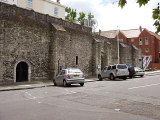 West town wall by Castle Vault and Castle Hall, Western Esplanade, 21.6.09, © I Peckham | 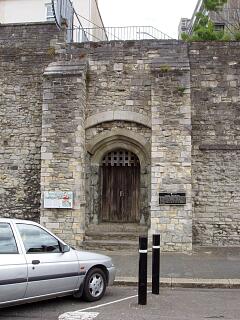 Watergate, Western Esplanade, 21.6.09, © I Peckham |
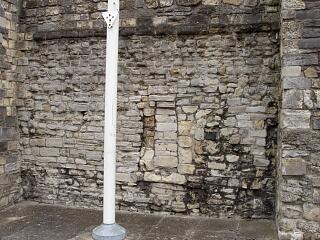 West wall of Castle Hall, Western Esplanade - blocking, 21.6.09, © I Peckham | 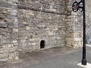 West wall of Castle Hall, Western Esplanade, 21.6.09, © I Peckham |
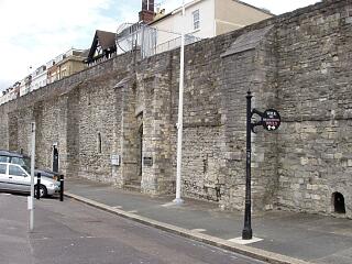 West town wall by Castle Vault, Watergate and Castle Hall, Western Esplanade, 21.6.09, © I Peckham | 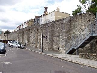 West town wall by Castle Vault, Watergate and Castle Hall, Western Esplanade, 21.6.09, © I Peckham |
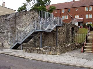 Castle Hall, Castle Garderobe and remains of south town wall, Western Esplanade, 21.6.09, © I Peckham | 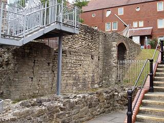 South wall of Castle Hall, Castle Garderobe and remains of south town wall, from Western Esplanade, 21.6.09, © I Peckham |
If you have any feedback or new information about this record, please email the Southampton HER (her@southampton.gov.uk).
Search results generated by the HBSMR Gateway from exeGesIS SDM Ltd.