Record Details
| MonUID: | MST2346 |
|---|
| HER Number: | 02356 |
|---|
| Type of record: | Place |
|---|
| Name: | Tutbury Borough |
|---|
Summary
A borough recorded in Domesday Survey of 1086, which may originally have been founded as an Anglo-Saxon burh. A market was granted to Tutbury by Henry de Ferrers in 1086.
Monument Type(s):
- TOWN (Norman to Tudor - 1066 AD to 1539 AD)
- TOWN (Tudor to Victorian - 1547 AD to 1899 AD)
- BURH? (Anglo Saxon - 650 AD to 1065 AD)
- MARKET (Established, Norman - 1086 AD to 1086 AD)
Associated Finds:
- UNIDENTIFIED OBJECT (Anglo Saxon to MEDIEVAL - 1000 AD to 1399 AD)
Associated Events:
- EST1241 - An archaeological watching brief at Ye Olde Dog and Partridge, Tutbury, July to August 2003. (NRHE Name - Ye Old Dog and Partridge, High Street) (Ref: DPT 03/58)
- EST1272 - Building recording survey at High Street, Tutbury, Staffordshire.
- EST1362 - An archaeological watching brief on land adjacent to 39 Cornmill Lane, Tutbury, April-May 2004. (NRHE Name - Land adjacent to 29 Cornmill Lane) (Ref: Report No. 1178)
- EST1390 - An archaeological watching brief to the rear of 33 High Street, Tutbury, September 2004. (NRHE Name - Land at 33 High Street) (Ref: Report No. 1228)
- EST743 - An archaeological desk-based assessment of land adjacent to 39 Cornmill Lane, Tutbury, January 2003. (NRHE Name - Land adjacent to 39 Cornmill Lane)
Full description
BOROUGH. BOROUGH RECORDED IN 1086. IT MAY BE AN EXTENSION OF TUTBURY. A SURVEY OF 1559 ASSERTS THAT ORIGINAL FOUNDATION AT TUTBURY PROVIDED FOR 182 BURGAGES. MANY INHABITANTS WERE STILL BUT BOROUGH STATUS LAPSED AT SOME DATE. <1>
The name 'Tutbury' is of Anglo-Saxon origin, and means 'Tutta's burg' or 'Stut's burg', that is to say the fortress of Tutta or Stut. This suggests that the town might have been founded as an Anglo-Saxon burh. The Anglo-Saxon Chronicle records the foundation of burhs at Tamworth and Stafford in 914 when Ethlefled drove out the Danes from this part of Mercia. It is possible that Tutbury was also fortified at this time. In the Domesday book of 1086, Tutbury is recorded, with Tamworth and Stafford as one of only three boroughs in the county, and as being the only place in the county with a market. The market probably dates from 1066-85, being instituted to serve the castle (PRN 00040) which is recorded in the Domesday Book. A new borough was founded at Tutbury by Robert de Ferrers I, earl of Derby (d.1139). Burgage tenure was mentioned there in 1141 and c1150 and a further extension was planned in 1150 and 1159. (JM, 19-Feb-2003) <2>
Two sherds of residual 11th-14th century pottery found to the rear of Ye Olde Dog and Partridge Hotel, High Street (PRN 08630), in a pit of 17th-18th century date. (JM, 26-Sept-2003) <3>
Evidence for medieval backplot activity was identified of Cornmill Lane during an archaeological watching brief. Two pits and an area of mid-brown material yielded medieval pottery and animal bone. The pottery was dated to the 14th-15th century. 19th century pottery was recovered from layers used to level up the site in the post-medieval period. (SB, 01-Oct-2004) <4>
An archaeological watching brief to the rear of 22 high street revealed evidence of 14th century activity, including a possible burgage plot boundary ditch (see PRN 50760). The north-south alignment of the ditch suggests that the alignment of the streets within the town may have been different during the 14th century, or that there may have been an additional road aligned east-west at this time which now no longer exists. (SB, 22-June-2005) <5>
A market was granted by Henry de Ferrers in 1086. (RB, 11-09-07) <6>
Sources and further reading
| --- | SST1707 - Cartographic: J. H. Barrett (Staffordshire County Council). 1967. Tutbury Central Area - Conjectural Restoration 1559. Paper. |
| --- | SST314 - Serial: Staffordshire Archaeological and Historical Society. 2010. Staffordshire Archaeological and Historical Society Transactions Volume XLIV (2010). |
| <1> | SST2313 - Serial: University of Keele. 1972. North Staffordshire Journal of Field Studies Volume 12 (1972). 'The Boroughs of Medieval Staffordshire' by D. M. Palliser, page 69. |
| <2> | SST3700 - Desk Based Assessment Report: Malcolm Hislop (Birmingham University Field Archaeology Unit). 2003. Land Adjacent to Cornmill Lane, Tutbury, Staffordshire: An Archaeological Desk-based Assessment. Pages 2-3. |
| <3> | SST4055 - Watching Brief Report: Challis, C (Thames Valley Archaeological Services). 2003. Ye Olde Dog and Partridge, High Street, Tutbury: An Archaeological Watching Brief. |
| <4> | SST1886 - Watching Brief Report: Erica Macey-Bracken (Birmingham Archaeology). 2004. Land Adjacent to 39 Cornmill Lane, Tutbury, Staffordshire: An Archaeological Watching Brief 2004. Pages 2-3. |
| <5> | SST1715 - Watching Brief Report: Helen Martin (Birmingham Archaeology). 2004. Land at 33 High Street, Tutbury, Staffordshire: An Archaeological Watching Brief. Page 3. |
| <6> | SST2265 - Serial: University of Keele. 1971. North Staffordshire Journal of Field Studies Volume 11 (1971). 'The Markets of Medieval Staffordshire' by D. M. Palliser & A. C. Pinnock, p52. |
Related records
| 08630 | Part of: Dog and Partridge Inn / Ye Olde Dog and Partridge Hotel (Building) |
| 04990 | Part of: Settlement Earthworks, Tutbury (Monument) |
| 00040 | Related to: Tutbury Castle Motte and Bailey (Monument) |
Associated Images
 Tutbury Central Area - Conjectural Restoration 1559
© Staffordshire County Council Tutbury Central Area - Conjectural Restoration 1559
© Staffordshire County Council Tutbury Central Area - Conjectural Restoration 1559
© Staffordshire County Council Tutbury Central Area - Conjectural Restoration 1559
© Staffordshire County Council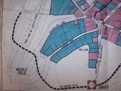 Tutbury Central Area - Conjectural Restoration 1559
© Staffordshire County Council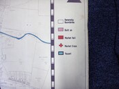 Tutbury Central Area - Conjectural Restoration 1559
© Staffordshire County Council Tutbury Central Area - Conjectural Restoration 1559
© Staffordshire County CouncilFeedback
If you have any comments or new information about this record, please email us.
Search results generated by the HBSMR Gateway from Exegesis Spatial Data Management.