| Name: | Road Barrier (destroyed), Cherrytree Chase, New Ranges, Shoeburyness/Great Wakering |
|---|
| SMR Number: | 20478 |
|---|
| Type of record: | Monument |
|---|
| Grid Reference: | TQ 954 864 |
|---|
| Map Sheet: | TQ98NE |
|---|
| Parish: | GREAT WAKERING, ROCHFORD, ESSEX |
|---|
| SOUTHEND ON SEA, ESSEX |
|---|
Summary
Road Barrier (destroyed)
Full description
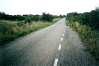
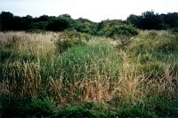
JULY 2000: An aerial photograph taken on 10 May 1946 shows ten anti-tank cubes, five each side of the grass track, at Cherrytree Chase, New Ranges. This position is where an anti-tank ditch (SMR 20477) "crossed" the track and a moveable obstruction, possibly a socket and railway line barrier, would have bridged the track between the cubes to connect up the two arms of the ditch. <1>
The former path of the ditch can be made out as a reed-filled depression on the N side of Cherrytree Chase. Nothing remains of the cubes. Two photos taken of site. <2>
<1> RAF, 1946, 106G-UK 1496-4410 (AP). SEX59719.
<2> Nash, Fred, 2000, WWII Defences in Southend-on-Sea, two frames, July 2000 (Photograph). SEX59602.
Monument Types
- ROAD BARRIER (WWII, Second World War - 1939 AD to 1945 AD)
Associated Events
- Survey of WWII Defences in Southend-on-Sea (Ref: Nash SOS 2000)
- F.Nash, July 2000 (Ref: Nash SOS/ROC Jul 2000)
Protected Status
- Historic Environment Character Zone: Rochford 6
- Historic Environment Character Zone: Thames Gateway 81_1
- Historic Environment Character Area: Thames Gateway 81
- Historic Environment Character Area: Rochford 4
Sources and further reading
| <1> | AP: RAF. 1946. 106G-UK 1496-4410. |
| <2> | Photograph: Nash, Fred. 2000. WWII Defences in Southend-on-Sea. two frames, July 2000. |
Images
 Road Barrier (destroyed), Cherrytree Chase, New Ranges, Shoeburyness © Essex County Council |  Road Barrier (destroyed), Cherrytree Chase, New Ranges, Shoeburyness © Essex County Council |
Search results generated by the HBSMR Gateway from exeGesIS SDM Ltd.