See important
guidance on the use of this record.
If you have any comments or new information about this record, please email us.
| HER Number: | MDV841 |
|---|
| Name: | Queen Anne's Walk, Barnstaple |
|---|
Summary
Formerly known as Merchant's Walk, Queen Anne's Walk comprises a covered stone colonnade. Built as an exchange, it is seen as an exceptional survival of Barnstaple's mercantile history. It is first documented in 1609 but was restored or rebuilt in 1708 when it was decorated with a statue of Queen Anne.
Location
| Grid Reference: | SS 556 331 |
|---|
| Map Sheet: | SS53SE |
|---|
| Admin Area | Devon |
|---|
| Civil Parish | Barnstaple |
|---|
| District | North Devon |
|---|
| Ecclesiastical Parish | BARNSTAPLE |
|---|
Protected Status
Other References/Statuses
- North Devon District Council Rescue Archaeology Unit Site Code: ND106
- Old DCC SMR Ref: SS53SE/68
- Old Listed Building Ref (I): 485832
- Ordnance Survey Archaeology Division: SS53SE9
Monument Type(s) and Dates
- EXCHANGE (Post Medieval to XIX - 1540 AD to 1900 AD)
Full description
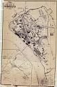
Wood, J., 1843, Plan of the Town of Barnstaple from Actual Survey (Cartographic). SDV91852.
A town plan of 1843 shows Queen Anne's Walk fronting directly onto Barnstaple Quay (before New Quay was built in the 1870s).
Amery, P. F. S., 1900-1901, A Tour across Dartmoor into North Devon by the Rev. John Swete 1789, 171 (Article in Serial). SDV18670.
Seen by Swete in 1789.
Pevsner, N., 1952, The Buildings of England: North Devon, 47 (Monograph). SDV336196.
Hoskins, W. G., 1954, A New Survey of England: Devon, 328 (Monograph). SDV17562.
Department of Environment, 1973, Barnstaple, 65 (List of Blds of Arch or Historic Interest). SDV89941.
Bone, M., 1973, Barnstaple's Industrial Archaeology, 13, 27/Drawing (Monograph). SDV78228.
Minchinton, W. E., 1976, Industrial Archaeology in Devon, 11 (Monograph). SDV7016.
Timms, S., 1981, Queen Anne's Walk (Personal Comment). SDV76888.
The building was re-roofed by the District Council (owners) in 1981.
Devon County Council, 1981, Queen Anne's Walk, Film 513 (Ground Photograph). SDV76907.
Weston, S., 1982, List of Field Monument Warden Visits (Un-published). SDV345675.
Department of Environment Field Monument Warden Visit.
Weston, S., 1983, List of Field Monument Warden Visits (Un-published). SDV345481.
Site visit by Department of Environment Field Monument Warden on 14th January 1983.
Historic Buildings and Monuments Commission, 1984, Letter from Historic Buildings and Monuments Commission to Devon County Council (Correspondence). SDV76891.
Letter confirming that this building was never finally scheduled and that it is not proposed to schedule it now, as it is adequately covered as a Grade I listed building.
Blaylock, S. R., 1986, Queen Anne's Walk, Barnstaple (Report - Survey). SDV76892.
When repairs were carried out in 1985 a survey was made of the structure. All the decorative detail was drawn and the structural history of the building discussed. It appears that the whole structure was dismantled when the baths were constructed in 1859, and the facade rebuilt integrally with the whole. Further repairs were undertaken in 1912 and 1923. The armorial bearings on the structure are illustrated and described.
Blaylock, S. R., 1987, Queen Anne's Walk, Barnstaple (Article in Serial). SDV354921.
A survey was undertaken when Queen Anne's Walk was undergoing repairs in January 1986.
Ferguson, P., 1993, The Restoration of Queen Anne's Walk, Barnstaple, 24-6 (Article in Serial). SDV76895.
Originally the building was a free-standing structure placed adjacent to late medieval quayside buildings. After the building's use as a public baths from 1859, it was converted to a Masonic Hall in 1868.
Timms, S., 20/06/1984, Queen Anne''s Walk (Personal Comment). SDV350518.
The District Council proposes to repair the stonework on the façade in 1984/5 with the aid of a grant from the Historic Buildings and Monuments Commission.
Exeter Archaeology, 2001, Archaeological Assessment and Building Recording at Commercial Road, Barnstaple, 10, Fig. 2 (Report - Assessment). SDV73888.
Queen Anne's Walk was know as the Merchants' Walk or the Merchant's Exchange until well into the 19th century. It consisted of an open colonnade at right angles to the River Taw. It was originally free-standing facing onto the quays in the area of The Strand. It was first mentioned in 1609 when a walking place was erected on the quay.
Ordnance Survey, 2012, MasterMap (Cartographic). SDV348725.
English Heritage, 2012, National Heritage List for England (National Heritage List for England). SDV348729.
Queen Annes Walk, The Strand. Exchange, now provided with public seats. 1708 (dated statue), possibly re-using earlier columns; roof probably 1859. Building has been attributed to William Talman ; restored 1986 by Herbert Read. Cream freestone (probably Beerstone); hipped slate roof with lead rolls. Originally a single colonnade, facing the quay (inlet since filled in). Building (separately listed) attached to rear of colonnade in 1859, perhaps replacing something earlier. 10-bay colonnade, left return with blind wall, right return open. Inside the colonnade 2 doorways and 2 into attached building. Single-storey. Sumptuously decorated. Fluted Tuscan columns, paired at left and right ends, support an entablature with pulminated frieze, parapet above, divided into rectangles with carved armorial bearings and decorated with urns. 6th bay from left broken forward with 2 pairs of fluted stone pillars supporting a bracketed pedestal, carved with armorial bearings and trophies, with a larger-than-lifesize statue of Queen Anne holding an orb and sceptre. Plaque below statue records that it was given by Robert Rolle of Stevenstone in 1708. Below this structure is the Tome Stone, placed here in 1909. Inside colonnade rear wall decorated with plain pilasters. Boarded roof to colonnade supported on circa 1859 cast-iron trusses with roundel decoration. HISTORICAL NOTE: an exceptional survival of Barnstaple's flourishing mercantile history. Date listed: 19th January 1951.
Southwest Archaeology, 2013, Greater Barnstaple Area Project Database, Mapping Area 96 (Un-published). SDV351581.
Building recording undertaken by Exeter Museums Archaeological Field Unit in 1986.
Watts, M., 2023, Barnstaple (Ground Photograph). SDV365422.
Queen Anne's Walk now fronts a café in the adjoining building. This was a later addition, originally built as a bath house. The paved, sunken area in front is all that remains of the Great Quay.
Friends of Archaeology ND, Unknown, Historic Barnstaple (Leaflet). SDV356772.
There was a merchant's walk here in 1598. The statue of Queen Anne was given by Richard Rolle in 1709.
Ancient Monuments, Unknown, Queen Anne's Walk (Schedule Document). SDV76884.
Queen Anne's Walk. Part of The Exchange, built 1708-1713, which still stands. An open portico known as Queen Anne's Walk, on what used to be the Town Quay (OS 6" XIII). A covered colonnade of stone, built as a merchant's venue. The building behind is modern and the back wall was originally blank.10 bays, Roman Doric columns, paired at corners and grouped under pediment. Parapet with cartouche shields and festoons surmounted by trophies and urns. Volute pediment over portico containing royal arms, supporting statue of Queen Anne with inscription dated 1708. The wall was completed in 1713 and repaired in 1796, but original design unaltered. Slate roof and modern iron trusses. In front stands the Tome Stone, a bargaining table with inscription.
Ordnance Survey Archaeology Division, Unknown, SS53SE9 (Ordnance Survey Archaeology Division Card). SDV76903.
Site visit 15th October 1953. Known as The Merchant's Walk until 1714. It has existed from an early unknown date. It was restored in 1714 and decorated with a statue of Queen Anne and the name was changed.
Sources / Further Reading
| SDV17562 | Monograph: Hoskins, W. G.. 1954. A New Survey of England: Devon. A New Survey of England: Devon. A5 Hardback. 328. |
| |
| | |
| SDV18670 | Article in Serial: Amery, P. F. S.. 1900-1901. A Tour across Dartmoor into North Devon by the Rev. John Swete 1789. Devon and Cornwall Notes and Queries. 1. Unknown. 171. |
| |
| | |
| SDV336196 | Monograph: Pevsner, N.. 1952. The Buildings of England: North Devon. The Buildings of England: North Devon. Paperback Volume. 47. |
| |
| | |
| SDV345481 | Un-published: Weston, S.. 1983. List of Field Monument Warden Visits. Lists of Field Monument Warden Visits. Printout. |
| |
| | |
| SDV345675 | Un-published: Weston, S.. 1982. List of Field Monument Warden Visits. Lists of Field Monument Warden Visits. Printout. |
| |
| | |
| SDV348725 | Cartographic: Ordnance Survey. 2012. MasterMap. Ordnance Survey. Map (Digital). [Mapped feature: #108442 ] |
| |
| | |
| SDV348729 | National Heritage List for England: English Heritage. 2012. National Heritage List for England. Website. |
| |
| | |
| SDV350518 | Personal Comment: Timms, S.. 20/06/1984. Queen Anne''s Walk. Not Applicable. |
| SDV351581 | Un-published: Southwest Archaeology. 2013. Greater Barnstaple Area Project Database. Greater Barnstaple Area Project. Digital. Mapping Area 96. |
| |
| | |
| SDV354921 | Article in Serial: Blaylock, S. R.. 1987. Queen Anne's Walk, Barnstaple. Exeter Archaeology 1985/6. A4 Stapled. |
| |
| | |
| SDV356772 | Leaflet: Friends of Archaeology ND. Unknown. Historic Barnstaple. Leaflet + Digital. |
| |
| | |
| SDV365422 | Ground Photograph: Watts, M.. 2023. Barnstaple. Photograph (Digital). |
| |  |
| | Linked images:6 |
| SDV7016 | Monograph: Minchinton, W. E.. 1976. Industrial Archaeology in Devon. Industrial Archaeology in Devon. Paperback Volume. 11. |
| |
| | |
| SDV73888 | Report - Assessment: Exeter Archaeology. 2001. Archaeological Assessment and Building Recording at Commercial Road, Barnstaple. Exeter Archaeology Report. 01.28. A4 Stapled + Digital. 10, Fig. 2. |
| |
| | |
| SDV76884 | Schedule Document: Ancient Monuments. Unknown. Queen Anne's Walk. |
| |
| | |
| SDV76888 | Personal Comment: Timms, S.. 1981. Queen Anne's Walk. Not Applicable. |
| SDV76891 | Correspondence: Historic Buildings and Monuments Commission. 1984. Letter from Historic Buildings and Monuments Commission to Devon County Council. Letter from Historic Buildings and Monuments Commission to Devon County Council. Letter. |
| SDV76892 | Report - Survey: Blaylock, S. R.. 1986. Queen Anne's Walk, Barnstaple. Exeter Museums Archaeological Field Unit Report. A4 Stapled + Digital. |
| |
| | |
| SDV76895 | Article in Serial: Ferguson, P.. 1993. The Restoration of Queen Anne's Walk, Barnstaple. North Devon Heritage Journal. 5. Unknown. 24-6. |
| |
| | |
| SDV76903 | Ordnance Survey Archaeology Division Card: Ordnance Survey Archaeology Division. Unknown. SS53SE9. Ordnance Survey Archaeology Division Card. Card Index. |
| |
| | |
| SDV76907 | Ground Photograph: Devon County Council. 1981. Queen Anne's Walk. Conservation Section Photograph Collection. Unknown. Film 513. |
| |
| | |
| SDV78228 | Monograph: Bone, M.. 1973. Barnstaple's Industrial Archaeology. Barnstaple's Industrial Archaeology. A5 Paperback. 13, 27/Drawing. |
| |
| | |
| SDV89941 | List of Blds of Arch or Historic Interest: Department of Environment. 1973. Barnstaple. Historic Houses Register. A4 Comb Bound. 65. |
| |
| | |
| SDV91852 | Cartographic: Wood, J.. 1843. Plan of the Town of Barnstaple from Actual Survey. Map + Digital. |
| |  |
| | Linked images:1 |
Associated Monuments
| MDV873 | Related to: Barnstaple Town Quay or Castle Quay (Monument) |
| MDV876 | Related to: Bath house building on The Strand, Barnstaple (Building) |
| MDV65741 | Related to: Fire Engine Station, Castle Street, Barnstaple (Building) |
| MDV61691 | Related to: Great Quay, Barnstaple (Monument) |
| MDV12494 | Related to: Tome Stone at Queen Anne's Walk, Barnstaple. (Monument) |
Associated Finds: none recorded
Associated Events
- EDV1607 - Archaeological assessment & building recording at Commercial Road, Barnstaple
| Date Last Edited: | Jan 24 2024 10:18AM |
|---|
Search results generated by the HBSMR Gateway from exeGesIS SDM Ltd.