See important
guidance on the use of this record.
If you have any comments or new information about this record, please email us.
| HER Number: | MDV109466 |
|---|
| Name: | The Old Shippen, Steart Farmstead, Bideford |
|---|
Summary
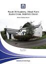
The Old Shippen, Steart Farmstead. Traditionally, this usually refers to a building in which cows or sheep are kept. The buildings alos include a horse gin house.
Location
| Grid Reference: | SS 356 228 |
|---|
| Map Sheet: | SS32SE |
|---|
| Admin Area | Devon |
|---|
| Civil Parish | Parkham |
|---|
| District | Torridge |
|---|
| Ecclesiastical Parish | PARKHAM |
|---|
Protected Status: none recorded
Other References/Statuses: none recorded
Monument Type(s) and Dates
- SHIPPON STOCK BUILDING (XVII to XVIII - 1601 AD (Between) to 1800 AD (Between))
- HORSE ENGINE (XIX - 1840 AD (Between) to 1886 AD (Between))
Full description
Jones Lang Lasalle, 2014, Route 39 Academy, Steart Farm, Bucks Cross, Bideford (Report - Assessment). SDV357827.
This building is an L-plan structure named The Old Shippen, traditionally this usually refers to a building in which cows or sheep are kept. However this structure is actually of late 20th century date and represents a partial reuse of the footprint of an earlier structure. The Tithe Map of 1840 shows a rectangular building here, which by 1886 had been extended to the south to form an L-plan. A semi-circular structure projecting from the northern side of the earlier building indicates the presence of a horse gin – an animal-powered mill for grinding grain and/or pumping water. This feature may have been in use at the time of the Tithe Map but was not covered and therefore not shown as part of the building.
Ordnance Survey, 2015, MasterMap (Cartographic). SDV357601.
Wessex Archaeology, 2017, Route 39 Academy, Steart Farm, Bucks Cross, Bideford, Devon: Historic Building Record (Report - Survey). SDV363518.
This building represents a former farm range and horse gin house. The building is split into 2 and joined by a stone wall. A 1997 drawing of the buildings shows a door between the buildings in the south east corner of what is referred to as Building 8 (see below).
The eastern section is referred to as Building 4 and represents a former farm range. It is an L shaped building constructed of Devonian slate stone and featuring a slate-clad pitched roof. It is comprised of two single-storey ranges and an east-west short range. Planning documents dated October 1997, provide evidence that the building was used as a cow house or shippon. The building was converted by Mark Rolle in the 20th century as evidenced by characteristic red bricking dressings around the window and door openings. A square recess in one of the walls of the west elevation of the south range is suggested to be the possible location of a commemorative plaque bearing Mark Rolle’s initials. Possible apotropaic marks were found on an original slate windowsill. At the time of the survey the building had already been converted into a modern living space so the interior was of little historic interest.
The building referred to as Building 8 is 19th century in date and was originally a former farm range and horse-gin, possibly built as part of the improvements by the Rolle estate. The horse-gin was located on the north side of the building and constructed between 1840 and 1886. The south and west side of the building are constructed entirely of stone whereas, there is evidence of cob on the north side. The Tithe map suggests the building may have originally been longer, however there is no fabric evidence for this. The door shown on the 1997 plan as mentioned above would allow for fodder or feed to be taken from Building 8 into Building 4.
Sources / Further Reading
| SDV357601 | Cartographic: Ordnance Survey. 2015. MasterMap. Ordnance Survey Digital Mapping. Digital. [Mapped feature: #68875 ] |
| |
| | |
| SDV357827 | Report - Assessment: Jones Lang Lasalle. 2014. Route 39 Academy, Steart Farm, Bucks Cross, Bideford. Jones Lang Lasalle. Digital. |
| |
| | |
| SDV363518 | Report - Survey: Wessex Archaeology. 2017. Route 39 Academy, Steart Farm, Bucks Cross, Bideford, Devon: Historic Building Record. Wessex Archaeology. 115060.02. Digital. |
| |  |
| | Linked documents:1 |
Associated Monuments: none recorded
Associated Finds: none recorded
Associated Events
- EDV6685 - Environmental Impact Assessment, Route 39 Academy, Steart Farm, Bucks Cross, Bideford
- EDV8269 - Historic Building Record at Route 39 Academy, Steart Farm, Bucks Cross, Bideford (Ref: 115060.02)
| Date Last Edited: | Aug 10 2023 9:18AM |
|---|
Search results generated by the HBSMR Gateway from exeGesIS SDM Ltd.