See important
guidance on the use of this record.
If you have any comments or new information about this record, please email us.
| HER Number: | MDV110073 |
|---|
| Name: | Former Platelayers Cabin, south of Sprey Point, Teignmouth |
|---|
Summary
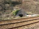
Small stone rubble building. Now roofless and rather overgrown.
Location
| Grid Reference: | SX 948 736 |
|---|
| Map Sheet: | SX97SW |
|---|
| Admin Area | Devon |
|---|
| Civil Parish | Teignmouth |
|---|
| District | Teignbridge |
|---|
Protected Status: none recorded
Other References/Statuses: none recorded
Monument Type(s) and Dates
- BUILDING (Built, XIX - 1801 AD to 1900 AD (Between))
Full description
Ordnance Survey, 1880-1899, First Edition Ordnance 25 inch map (Cartographic). SDV336179.
Building shown in this location. Probably associated with the adjacent limekiln.
Ordnance Survey, 1904 - 1906, Second Edition Ordnance Survey 25 inch Map (Cartographic). SDV325644.
Building shown.
Pink, F., 2014-2015, South Devon Coast Rapid Coastal Zone Assessment Survey Desk-Based Assessment (Interpretation). SDV357736.
A building is depicted on the western edge of the railway on the First and Second Edition 25 inch Ordnance Survey maps. A building is also present in this location on the Ordnance Survey Master Map, although it appears to be smaller in size. The building is not labelled on these maps, but its close proximity to the railway indicates that it may be associated with the railway line.
Ordnance Survey, 2015, MasterMap (Cartographic). SDV357601.
Small square building shown.
Historic England, 2018, Former Platelayers Cabin south of Sprey Point, Former Lime Kiln south of Sprey Point, Storage Building north end of Sprey Point, Teignmouth. (List of Blds of Arch or Historic Interest). SDV360796.
Historic England has been asked to assess a number of structures on the railway line between Dawlish and Teignmouth, Devon for listing through a request for a Certificate of Immunity (COI) from Listing. These structures include the line side buildings and structure around Sprey Point which are the subject of this assessment.
The line-side building stands on the north-west side of the section of line that runs between Eastcliff and Parsons Tunnel, and 200m to the south of Sprey Point. It appears on late-C19 plans and maps and it was probably built in the mid-C19, after the railway was first established. It was a platelayers' cabin which provided shelter for railway employees maintaining this section of the line. Such structures were typically single-cell buildings, usually containing a heating stove. The building is now (2017) a ruin.
Details
A former platelayers' cabin built in around the mid-C19, now ruinous.
MATERIALS: the building is constructed of rubble-stone.
PLAN: a rectangular, single-cell building on a south-east to north-west alignment.
EXTERIOR: a single-storey, gable-end building that stands on the north-western side of the
railway track. The roof is no longer extant. There is an arched entrance in the south gable end. The other elevations are obscured by vegetation. The ground level has been raised around the building.
INTERIOR: not inspected.
Historic England, 2018, Two Trackside Buildings and a Lime Kiln Around Sprey Point (List of Blds of Arch or Historic Interest). SDV361188.
Notification that following a recommendation from Historic England, the Secretary of State for Digital, Culture, Media and Sport has decided not to list the building but is minded to issue a Certificate of Immunity from Listing (COI).
The South Devon Railway was first laid out in 1846 and designed by Isambard Kingdom Brunel during the pioneering phase of railway development in Britain. The trackside buildings and the lime kiln near to Sprey Point do not appear on William Dawson's 1840s drawings of the railway. They are, however, shown on South Devon Railway's 1874 survey. The former platelayer's building and the lime kiln on the north side of the tracks appear to have been partially buried when the line was widened in the 1880s.
The FORMER PLATELAYER'S BUILDING on the north side of the railway line has lost its roof and is very overgrown. Its walls are of simple rubble-stone construction and have been partially buried since the line was widened in the 1880s. The other TRACKSIDE BUILDING at Sprey Point, on the south side of the line, retains a greater proportion of its fabric. However, it is a modest single-storey structure with a simple pitched-roof and a single arched opening in the north gable wall. The roof has been recovered with corrugated metal sheets. Both of these buildings are plain, functional structures which lack architectural interest. The C19 LIME KILN it not a particularly early example of its type. There are several examples of listed lime kilns associated with railways, including a five-kiln structure at Bollihope Burn in Stanhope, County Durham built for the Stockton and Darlington Railway Company (late 1840s, Grade II). In comparison, the lime kiln near Sprey Point is a simple, single-kiln structure. It also does not form part of a larger group of associated listed industrial or transport structures and is not of sufficient architectural or technological interest to merit listing.
All three structures have local historic interest as features associated with this early railway line which was established by Brunel and they relate to the maintenance of this prominent coastal railway route. However, as plain, functional structures they are not of sufficient special architectural or historic interest to merit listing. After examining all the records and other relevant information and having carefully considered the architectural and historic interest of this case, the criteria for listing are not fulfilled. Certificates of Immunity from Listing are recommended for the two trackside buildings and the nearby lime kiln at Sprey Point.
REASONS FOR DESIGNATION DECISION
It is recommended that Certificates of Immunity from Listing should be issued for the two trackside buildings and the lime kiln on the railway line to the east of Teignmouth for the following principal reasons:
Architectural interest:
* these mid-/late-C19 structures are architecturally plain and lack any technological or design interest;
* the former platelayer's building has lost a significant amount of original fabric; the other trackside building and the lime kiln survive comparatively well, but are architecturally modest.
Historic interest:
* the structures are situated on the former South Devon Railway which was first established in 1846 and designed by Brunel. However, this association is not sufficient to compensate for the lack of architectural or technological interest for these ancillary railway structures.
Group value:
* they do not form a group with any listed railway or transport structures.
See report for further details.
Historic England, 2018, Two Trackside Buildings and a Lime Kiln Around Sprey Point (List of Blds of Arch or Historic Interest). SDV361207.
Confirmation that the building has been issued with a Certificate of Immunity from listing for five years.
Watts, S., 21/02/2015, Ruined Building at Teignmouth (Ground Photograph). SDV357911.
Sources / Further Reading
| SDV325644 | Cartographic: Ordnance Survey. 1904 - 1906. Second Edition Ordnance Survey 25 inch Map. Second Edition Ordnance Survey 25 inch Map. Map (Digital). |
| |
| | |
| SDV336179 | Cartographic: Ordnance Survey. 1880-1899. First Edition Ordnance 25 inch map. First Edition Ordnance Survey 25 inch Map. Map (Digital). |
| |
| | |
| SDV357601 | Cartographic: Ordnance Survey. 2015. MasterMap. Ordnance Survey Digital Mapping. Digital. [Mapped feature: #69522 ] |
| |
| | |
| SDV357736 | Interpretation: Pink, F.. 2014-2015. South Devon Coast Rapid Coastal Zone Assessment Survey Desk-Based Assessment. AC Archaeology Report. Digital. |
| |  |
| | Linked documents:1 |
| SDV357911 | Ground Photograph: Watts, S.. 21/02/2015. Ruined Building at Teignmouth. Photograph (Digital). |
| |  |
| | Linked images:1 |
| SDV360796 | List of Blds of Arch or Historic Interest: Historic England. 2018. Former Platelayers Cabin south of Sprey Point, Former Lime Kiln south of Sprey Point, Storage Building north end of Sprey Point, Teignmouth.. Certificate of Immunity. Digital. |
| |
| | |
| SDV361188 | List of Blds of Arch or Historic Interest: Historic England. 2018. Two Trackside Buildings and a Lime Kiln Around Sprey Point. Notification of Intention to Grant a Certificate of Immunity. Digital. |
| |
| | |
| SDV361207 | List of Blds of Arch or Historic Interest: Historic England. 2018. Two Trackside Buildings and a Lime Kiln Around Sprey Point. Notification of Certificate of Immunity. Digital. |
| |
| | |
Associated Monuments
| MDV52723 | Related to: Limekiln to the south of Sprey Point, Teignmouth (Monument) |
Associated Finds: none recorded
Associated Events: none recorded
| Date Last Edited: | Aug 5 2019 4:31PM |
|---|
Search results generated by the HBSMR Gateway from exeGesIS SDM Ltd.