See important
guidance on the use of this record.
If you have any comments or new information about this record, please email us.
| HER Number: | MDV118692 |
|---|
| Name: | Pound Farm, Ivybridge |
|---|
Summary
Site of a pound house shown on the Tithe Map. The present farmstead was built in about 1850. The stones of a cider mill were found recently in the boundary wall between the farm and the school.
Location
| Grid Reference: | SX 632 561 |
|---|
| Map Sheet: | SX65NW |
|---|
| Admin Area | Devon |
|---|
| Civil Parish | Ivybridge |
|---|
| District | South Hams |
|---|
| Ecclesiastical Parish | ERMINGTON |
|---|
Protected Status: none recorded
Other References/Statuses: none recorded
Monument Type(s) and Dates
- CIDER HOUSE (Unknown date)
- FARMSTEAD (Built, XIX - 1801 AD to 1900 AD (Between))
Full description
South West Heritage Trust, 1838-1848, Digitised Tithe Maps and Transcribed Apportionments (Cartographic). SDV359954.
Recorded as Waste and Pound House (plot 188).
Devon County Council, 1838-1848, Tithe Mosaic, approximately 1838-1848 (Cartographic). SDV349431.
Single building shown.
Ordnance Survey, 1880-1899, First Edition Ordnance 25 inch map (Cartographic). SDV336179.
Marked as 'Pound Farm On site of a Manor House'. Comprising a large building, the farmhouse, adjacent to the lane with a range of smaller buildings around a courtyard to the south. On the south-west side of the farm is a large orchard (now a primary school).
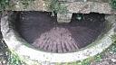
Thatcher, L., Ivybridge Heritage & Archives Group, 2016, Cider Pound Stone at Pound Farm, Ivybridge (Ground Photograph). SDV360063.
Pound farm was built in about 1850, apparently on the site of the original Ivybridge manor. The stones of a cider mill were found in the boundary wall between the farm and the primary school. The trough is about 98 inches diameter and 15.75 inches high. The grinding stone, now set in the wall above, is 46 inches long and 11 inches high, with a central post hole of 7 inches
Manor Primary School Ivybridge, Unknown, Devon Farms: Pound Farm (Leaflet). SDV361407.
The farmhouse is Victorian but the barn was built about 500 years ago. Called Pound Farm from the pound stones used for making cider. Manor Primary School is built on the site of one of the former orchards.
Sources / Further Reading
| SDV336179 | Cartographic: Ordnance Survey. 1880-1899. First Edition Ordnance 25 inch map. First Edition Ordnance Survey 25 inch Map. Map (Digital). |
| |
| | |
| SDV349431 | Cartographic: Devon County Council. 1838-1848. Tithe Mosaic, approximately 1838-1848. Digitised Tithe Map. Digital. |
| |
| | |
| SDV359954 | Cartographic: South West Heritage Trust. 1838-1848. Digitised Tithe Maps and Transcribed Apportionments. Tithe Map and Apportionment. Digital. |
| |
| | |
| SDV360063 | Ground Photograph: Thatcher, L., Ivybridge Heritage & Archives Group. 2016. Cider Pound Stone at Pound Farm, Ivybridge. Email to S. Reed. Digital. |
| |  |
| | Linked images:7 |
| SDV361407 | Leaflet: Manor Primary School Ivybridge. Unknown. Devon Farms: Pound Farm. Digital. |
| |
| | |
Associated Monuments
| MDV118694 | Related to: Cider Trough at Pound Farm, Ivybridge (Monument) |
| MDV20055 | Related to: Manor House at Pound Farm, Ivybridge (Monument) |
Associated Finds: none recorded
Associated Events: none recorded
| Date Last Edited: | Jun 13 2018 10:23AM |
|---|
Search results generated by the HBSMR Gateway from exeGesIS SDM Ltd.