See important
guidance on the use of this record.
If you have any comments or new information about this record, please email us.
| HER Number: | MDV122015 |
|---|
| Name: | Building, Higher Corrie Farm, Dalwood, East Devon |
|---|
Summary
Geophysical survey recorded a group of anomalies likely to represent a former building associated with the site of Higher Corry, which was deserted in the second half of the nineteenth century.
Location
| Grid Reference: | ST 244 011 |
|---|
| Map Sheet: | ST20SW |
|---|
| Admin Area | Devon |
|---|
| Civil Parish | Stockland |
|---|
| District | East Devon |
|---|
| Ecclesiastical Parish | STOCKLAND |
|---|
Protected Status: none recorded
Other References/Statuses: none recorded
Monument Type(s) and Dates
- AGRICULTURAL BUILDING? (XIII to XIX - 1201 AD to 1900 AD (Between))
Full description
Smart, C., 2017, Higher Corrie Farm, Dalwood, East Devon: Geophysical Survey (Report - Geophysical Survey). SDV361121.
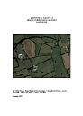
This report presents the results of geophysical survey (magnetometer) of land at Higher Corrie Farm, Dalwood, East Devon (Figure 1; ST 24380 01164). The site comprises an irregular-shaped field northwest of the main farm complex. The purpose of the survey was to define the extent, nature and significance of any sub-surface archaeological remains whether corresponding to the recognised earthworks or not. The possibility of the site being once occupied by a Roman camp would have provided significant new evidence for the character of military movement through the south west of Britain in the middle decades of the first century AD. Unfortunately, there is little within the results of the survey to support this suggestion. Instead, the results suggest that the earthworks are related to the site of Higher Corry, which was deserted in the second half of the nineteenth century.
The site has the potential to yield important information regarding the origins, life, and decay of a West Country household from perhaps the 13th to 19th centuries. Furthermore, the results of the survey suggest that the farmstead was once more extensive than shown on the parish tithe map and it might be that this was once a larger grouping of individual farms that became consolidated into a single holding. In terms of significance it is generally accepted the pattern of dispersed hamlets and farms in this region is of medieval origin so, in this regard, Higher Corry is not exceptional. Its significance is, however, elevated because of the fact that it was deserted in the second half of the 19th century and in this case it is unusual. The site, if further investigation or excavation was undertaken, could open a rare window on settlement, social and economic dynamics throughout the second millennium AD. Excavation of such places is not common, with the only directly comparable examples being the extant farms abandoned and excavated during the construction of Roadford Reservoir in West Devon.
Internally, this possible structure measures c. 45 metres by 25 metres,
which is large for a domestic building. Alternatively, the anomalies represent a series of smaller buildings arranged around a central courtyard, and this presents a more logical situation.
Sources / Further Reading
| SDV361121 | Report - Geophysical Survey: Smart, C.. 2017. Higher Corrie Farm, Dalwood, East Devon: Geophysical Survey. University of Exeter. Digital. |
| |  |
| | Linked documents:1 |
Associated Monuments: none recorded
Associated Finds: none recorded
Associated Events
- EDV7535 - Geophysical Survey: Higher Corrie Farm, Dalwood, East Devon
| Date Last Edited: | Apr 25 2018 4:28PM |
|---|
Search results generated by the HBSMR Gateway from exeGesIS SDM Ltd.