See important
guidance on the use of this record.
If you have any comments or new information about this record, please email us.
| HER Number: | MDV122026 |
|---|
| Name: | Ring Ditch, Cloverhayes, Smallridge, East Devon |
|---|
Summary
Geophysical survey recorded two anomaly groups, which may represent ring ditches associated with round structures.
Location
| Grid Reference: | ST 298 011 |
|---|
| Map Sheet: | ST20SE |
|---|
| Admin Area | Devon |
|---|
| Civil Parish | All Saints |
|---|
| District | East Devon |
|---|
| Ecclesiastical Parish | AXMINSTER |
|---|
Protected Status: none recorded
Other References/Statuses: none recorded
Monument Type(s) and Dates
- RING DITCH? (LANEBA to Late Bronze Age - 2500 BC? to 701 BC (Between))
Full description
Smart, C., 2017, Cloverhayes, Smallridge, East Devon: Geophysical Survey (Report - Geophysical Survey). SDV361131.
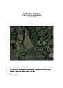
This report presents the results of geophysical survey (magnetometer) of land at Cloverhayes, Smallridge, East Devon. The site comprises a long triangular-shaped field immediately south of Cloverhayes, on the northwest edge of Smallridge hamlet. The purpose of the survey was to define the extent, nature and significance of any sub-surface archaeological remains whether corresponding to the recognised vegetation marks or not. The possibility of the site being once occupied by a Roman camp would have provided significant new evidence for the character of military movement through the south west of Britain in the middle decades of the first century AD. It it is evident that there is no support in the results of the magnetic survey for the anomalies transcribed from aerial photographs. Specifically, there is no evidence for a rectilinear enclosure or Roman camp.
There are a number of positive point anomalies in the vicinity of the proposed enclosures, and the fact that such anomalies are restricted to the same area reinforces the proposal that this is the focus of the area of archaeological interest. Furthermore, there is a clear circular positive linear anomaly (D), measuring 4.9 metres across, on the western edge of survey area that is interpreted as a ring gully or ditch associated with a round structure. A second anomaly (E), 19 metres to the southeast, has similar characteristics but has a weaker magnetic response.
Sources / Further Reading
| SDV361131 | Report - Geophysical Survey: Smart, C.. 2017. Cloverhayes, Smallridge, East Devon: Geophysical Survey. University of Exeter. Digital. [Mapped feature: #111574 ] |
| |  |
| | Linked documents:1 |
Associated Monuments: none recorded
Associated Finds: none recorded
Associated Events
- EDV7536 - Geophysical Survey: Cloverhayes, Smallridge, East Devon
| Date Last Edited: | Apr 27 2018 5:41PM |
|---|
Search results generated by the HBSMR Gateway from exeGesIS SDM Ltd.