See important
guidance on the use of this record.
If you have any comments or new information about this record, please email us.
| HER Number: | MDV124647 |
|---|
| Name: | Limekiln in Smugglers Lane, Holcombe |
|---|
Summary
Remains of a limekiln in Smugglers Lane.
Location
| Grid Reference: | SX 955 747 |
|---|
| Map Sheet: | SX97SE |
|---|
| Admin Area | Devon |
|---|
| Civil Parish | Dawlish |
|---|
| District | Teignbridge |
|---|
| Ecclesiastical Parish | DAWLISH |
|---|
Protected Status: none recorded
Other References/Statuses: none recorded
Monument Type(s) and Dates
- LIME KILN (Built, XVIII to XIX - 1701 AD to 1900 AD (Between))
Full description
Devon County Council, 1838-1848, Tithe Mosaic, approximately 1838-1848 (Cartographic). SDV349431.
Limekiln depicted as a circular feature on the east side of the road, about a third of the way down the lane.
Ordnance Survey, 1880-1899, First Edition Ordnance 25 inch map (Cartographic). SDV336179.
Limekiln not marked.
Garnsworthy, P., 2013, Brunel's Atmostpheric Railway, 53 (Monograph). SDV360708.
The limekiln is shown as a round, red circle on the route plan from Parson Tunnel to Teignmouth Tunnel, painted by William Dawson in the 1840s.
Google, 2019, Google Streetview (Website). SDV362731.
Lime kiln on north side of lane, now very overgrown. A modern concrete and brick frontage has been added to it. This formerly had double doors, but one has fallen off and the entrance is now covered with wire mesh.
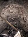
Sheppard-Allen, C., 2019, Lime kiln at Smugglers Lane, Holcombe (Ground Photograph). SDV362759.
Photo of interior of limekiln on north side of Smugglers Lane. The kiln was hidden from view behind wooden gates, possibly for use as a storage area, but these have now partially collapsed.
Sources / Further Reading
| SDV336179 | Cartographic: Ordnance Survey. 1880-1899. First Edition Ordnance 25 inch map. First Edition Ordnance Survey 25 inch Map. Map (Digital). |
| |
| | |
| SDV349431 | Cartographic: Devon County Council. 1838-1848. Tithe Mosaic, approximately 1838-1848. Digitised Tithe Map. Digital. |
| |
| | |
| SDV360708 | Monograph: Garnsworthy, P.. 2013. Brunel's Atmostpheric Railway. Brunel's Atmostpheric Railway. Paperback Volume. 53. |
| |
| | |
| SDV362731 | Website: Google. 2019. Google Streetview. http://maps.google.co.uk. Website. |
| |
| | |
| SDV362759 | Ground Photograph: Sheppard-Allen, C.. 2019. Lime kiln at Smugglers Lane, Holcombe. Email to Archaeology Team. Email. |
| |  |
| | Linked images:1 |
Associated Monuments: none recorded
Associated Finds: none recorded
Associated Events: none recorded
| Date Last Edited: | Jan 16 2019 1:40PM |
|---|
Search results generated by the HBSMR Gateway from exeGesIS SDM Ltd.