See important
guidance on the use of this record.
If you have any comments or new information about this record, please email us.
| HER Number: | MDV125955 |
|---|
| Name: | Earthwork on Land at Clickland, Ermington |
|---|
Summary
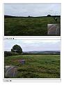
Modern banked and ditched earthwork visible on EA LiDAR and recent aerial photography. Confirmed as former racetrack used by local garage.
Location
| Grid Reference: | SX 618 522 |
|---|
| Map Sheet: | SX65SW |
|---|
| Admin Area | Devon |
|---|
| Civil Parish | Ermington |
|---|
| District | South Hams |
|---|
| Ecclesiastical Parish | ERMINGTON |
|---|
Protected Status: none recorded
Other References/Statuses: none recorded
Monument Type(s) and Dates
- NON ANTIQUITY (Late 20th Century to XXI - 1990 AD to 2013 AD (Between))
Full description
South West Heritage Trust, 1838-1848, Digitised Tithe Maps and Transcribed Apportionments (Cartographic). SDV359954.
Field name, Great Clickland Field. Field 1162.
GetMapping, 1999 - 2000, Dartmoor 1999-2000 1:1250 Aerial Photography (digital) (Aerial Photograph). SDV345751.
Earthwork first visible on 1999-2000 photography, indicating it is likely to be modern.
Battershill, M., 2019, Earthwork at Clickland Down, Ermington (Correspondence). SDV363070.
Earthwork identified on LiDAR. Speculated to be an ovoid feature in the field, possibly a pound or similar. Mentioned Anglo-Saxon burghs in the South Hams and this lane being a prehistoric watershed ridgeway. Notes that the lane follows the feature.
On 17th July 2019, M, Battershill, emailed to confirm that after getting in touch with a parishioner the field was once rented to the owner of a local garage who used the field to run banger races in the 1990s.
Garne, R., 2019, Earthwork on Land at Clickland, Ermington (Personal Comment). SDV363071.
The earthworks are clearly visible on LiDAR and 1999-2000 aerial photography, but are not visible on the RAF photographs. Likely that the feature is modern, looks unlikely that it would be the result of agricultural activity as it only takes up part of the field. The field above on the tithe map is called Quarry Park, however again it looks unlikely that this would be the result of quarrying especially considering how little evidence there is of the feature prior to 1999. After speaking to the NMP officers, there is a collective feeling that this feature is modern, however investigations are ongoing.
Sources / Further Reading
| SDV345751 | Aerial Photograph: GetMapping. 1999 - 2000. Dartmoor 1999-2000 1:1250 Aerial Photography (digital). Digital. |
| |
| | |
| SDV359954 | Cartographic: South West Heritage Trust. 1838-1848. Digitised Tithe Maps and Transcribed Apportionments. Tithe Map and Apportionment. Digital. |
| |
| | |
| SDV363070 | Correspondence: Battershill, M.. 2019. Earthwork at Clickland Down, Ermington. Correspondence with Historic Environment Service. Email + Digital. |
| |  |
| | Linked documents:1 |
| SDV363071 | Personal Comment: Garne, R.. 2019. Earthwork on Land at Clickland, Ermington. |
| |
| | |
Associated Monuments: none recorded
Associated Finds: none recorded
Associated Events: none recorded
| Date Last Edited: | Dec 4 2019 12:01PM |
|---|
Search results generated by the HBSMR Gateway from exeGesIS SDM Ltd.