See important
guidance on the use of this record.
If you have any comments or new information about this record, please email us.
| HER Number: | MDV126021 |
|---|
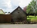
| Name: | Former stables at 1 Hardys Court, Colaton Raleigh |
|---|
Summary
Late 18th, early 19th century former stable block.
Location
| Grid Reference: | SY 076 876 |
|---|
| Map Sheet: | SY08NE |
|---|
| Admin Area | Devon |
|---|
| Civil Parish | Colaton Raleigh |
|---|
| District | East Devon |
|---|
| Ecclesiastical Parish | COLATON RALEIGH |
|---|
Protected Status: none recorded
Other References/Statuses: none recorded
Monument Type(s) and Dates
- STABLE (Built, XIX to XX - 1880 AD to 1906 AD (Between))
Full description
Ordnance Survey, 1904 - 1906, Second Edition Ordnance Survey 25 inch Map (Cartographic). SDV325644.
Building shown.
Planning Officer, East Devon District Council, 2019, Former Stables at 1 Hardys Court, Colaton Raleigh (Ground Photograph). SDV363104.
Photos of the old stables. A planning application has been made for the demolition of the building and the construction of a new bungalow on the site.
Ordnance Survey, 2019, MasterMap 2019 (Cartographic). SDV362729.
Sources / Further Reading
| SDV325644 | Cartographic: Ordnance Survey. 1904 - 1906. Second Edition Ordnance Survey 25 inch Map. Second Edition Ordnance Survey 25 inch Map. Map (Digital). |
| |
| | |
| SDV362729 | Cartographic: Ordnance Survey. 2019. MasterMap 2019. Ordnance Survey Digital Mapping. Digital. [Mapped feature: #118643 ] |
| |
| | |
| SDV363104 | Ground Photograph: Planning Officer, East Devon District Council. 2019. Former Stables at 1 Hardys Court, Colaton Raleigh. Digital. |
| |  |
| | Linked images:3 |
Associated Monuments: none recorded
Associated Finds: none recorded
Associated Events: none recorded
| Date Last Edited: | Jul 12 2019 9:31AM |
|---|
Search results generated by the HBSMR Gateway from exeGesIS SDM Ltd.