See important
guidance on the use of this record.
If you have any comments or new information about this record, please email us.
| HER Number: | MDV126149 |
|---|
| Name: | Posts in the Crydda on St Mary's Road, Croyde |
|---|
Summary
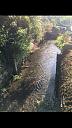
Posts in the Crydda on St Mary's Road, Croyde where the stream could be dammed in order to provide large amounts of water when fires occurred.
Location
| Grid Reference: | SS 445 391 |
|---|
| Map Sheet: | SS43NW |
|---|
| Admin Area | Devon |
|---|
| Civil Parish | Georgeham |
|---|
| District | North Devon |
|---|
| Ecclesiastical Parish | GEORGEHAM |
|---|
Protected Status: none recorded
Other References/Statuses: none recorded
Monument Type(s) and Dates
- SLUICE GATE (XX - 1901 AD to 2000 AD (Between))
Full description
Google, 2019, Google Streetview (Website). SDV362731.
Posts visible. A fire hydrant sign is placed on the wall nearby.
Howes, K., 2019, Posts in the Crydda (Ground Photograph). SDV363135.
Posts in the Crydda on St Mary's Road, Croyde where the stream could be dammed in order to provide large amounts of water when fires occurred.
Sources / Further Reading
| SDV362731 | Website: Google. 2019. Google Streetview. http://maps.google.co.uk. Website. [Mapped feature: #118929 ] |
| |
| | |
| SDV363135 | Ground Photograph: Howes, K.. 2019. Posts in the Crydda. Digital. |
| |  |
| | Linked images:1 |
Associated Monuments: none recorded
Associated Finds: none recorded
Associated Events: none recorded
| Date Last Edited: | Jul 26 2019 10:05AM |
|---|
Search results generated by the HBSMR Gateway from exeGesIS SDM Ltd.