See important
guidance on the use of this record.
If you have any comments or new information about this record, please email us.
| HER Number: | MDV126274 |
|---|
| Name: | Boundary stone on Burley Down, Lewtrenchard |
|---|
Summary
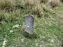
Current site of a boundary stone which is marked on historic mapping on the parish boundary between Bridestowe and Lewtrenchard some 100 metres to the north-east. The stone is inscribed 'H' on one side and 'C' or 'G' on another. The initials suggest the stone marked a land holding rather than parish boundary although the two coincide at the stone's original location.
Location
| Grid Reference: | SX 489 868 |
|---|
| Map Sheet: | SX48NE |
|---|
| Admin Area | Devon |
|---|
| Civil Parish | Lewtrenchard |
|---|
| District | West Devon |
|---|
| Ecclesiastical Parish | LEWTRENCHARD |
|---|
Protected Status: none recorded
Other References/Statuses: none recorded
Monument Type(s) and Dates
- BOUNDARY STONE (XVIII - 1701 AD to 1800 AD (Between))
Full description
Noakes, R., 2019, Boundary Stone (Ground Photograph). SDV363172.
Site visit 4th August 2019. Extant boundary stone at SX4894 8689. Inscribed 'H' and 'G' or 'C'.
Sources / Further Reading
| SDV363172 | Ground Photograph: Noakes, R.. 2019. Boundary Stone. Digital. [Mapped feature: #119257 ] |
| |  |
| | Linked images:2 |
Associated Monuments
| MDV58580 | Related to: Boundary Stone on Burley Down (Monument) |
Associated Finds: none recorded
Associated Events: none recorded
| Date Last Edited: | Aug 14 2019 10:35AM |
|---|
Search results generated by the HBSMR Gateway from exeGesIS SDM Ltd.