See important
guidance on the use of this record.
If you have any comments or new information about this record, please email us.
| HER Number: | MDV128166 |
|---|
| Name: | Houses on Church Green, Lapford |
|---|
Summary
The Lapford Tithe Map shows that the eastern end of what is now the churchyard was formerly occupied by houses and gardens. These were demolished by the end of the 19th century and the churchyard extended. The surviving part of the plots became the church green.
Location
| Grid Reference: | SS 731 082 |
|---|
| Map Sheet: | SS70NW |
|---|
| Admin Area | Devon |
|---|
| Civil Parish | Lapford |
|---|
| District | Mid Devon |
|---|
| Ecclesiastical Parish | LAPFORD |
|---|
Protected Status
Other References/Statuses: none recorded
Monument Type(s) and Dates
- HOUSE (Built, Post Medieval to XIX - 1540 AD? to 1850 AD (Between))
Full description
South West Heritage Trust, 1838-1848, Digitised Tithe Maps and Transcribed Apportionments (Cartographic). SDV359954.
The Lapford Tithe Map shows that the eastern end of what is now the churchyard was formerly occupied by houses and gardens (plots 301 and 293).
Ordnance Survey, 1880-1899, First Edition Ordnance 25 inch map (Cartographic). SDV336179.
The 1880s-1890s map shows the houses to have been demolished and the churchyard extended.
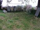
Egan, D., 2020, Lapford (Ground Photograph). SDV363665.
There is a mid 17th century documentary reference to the repair of the church path between Rich Searles house and the sheephouse gate. It is also of note that all the gravestones near the lychgate are dated since 1880, suggesting that this end of the churchyard is late 19th century in origin.
Sources / Further Reading
| SDV336179 | Cartographic: Ordnance Survey. 1880-1899. First Edition Ordnance 25 inch map. First Edition Ordnance Survey 25 inch Map. Map (Digital). |
| |
| | |
| SDV359954 | Cartographic: South West Heritage Trust. 1838-1848. Digitised Tithe Maps and Transcribed Apportionments. Tithe Map and Apportionment. Digital. |
| |
| | |
| SDV363665 | Ground Photograph: Egan, D.. 2020. Lapford. Digital. |
| |  |
| | Linked images:1 |
Associated Monuments
| MDV108242 | Related to: Church Green, Lapford (Monument) |
Associated Finds: none recorded
Associated Events: none recorded
| Date Last Edited: | Jul 17 2020 2:10PM |
|---|
Search results generated by the HBSMR Gateway from exeGesIS SDM Ltd.