See important
guidance on the use of this record.
If you have any comments or new information about this record, please email us.
| HER Number: | MDV132527 |
|---|
| Name: | Royal Naval Shore Signal Station, South Down Common, Beer |
|---|
Summary
A rectangular structure is interpreted as the remains of a First or Second World War Royal Naval signal station. It is visible on aerial photographs taken from the 1940s onwards.
Location
| Grid Reference: | SY 219 881 |
|---|
| Map Sheet: | SY28NW |
|---|
| Admin Area | Devon |
|---|
| Civil Parish | Beer |
|---|
| District | East Devon |
|---|
| Ecclesiastical Parish | SEATON |
|---|
Protected Status: none recorded
Other References/Statuses: none recorded
Monument Type(s) and Dates
- SIGNAL STATION (World War I to World War II - 1914 AD (Between) to 1945 AD (Between))
Full description
Royal Air Force, 1946 - 1949, Royal Air Force Aerial Photographs (Aerial Photograph). SDV342938.
A rectangular structure, approximately 4 by 5 metres in plan, is visible. Its shadow suggests it has a flat roof, possibly with a pole or staff on top. A dark mark on the north and east sides, approximately 20 metres from the structure, may indicate a perimeter barbed wire fence. A track or footpath leads north-east, apparently linking this structure with the radar station to the east.
Horner, B., 2022, Archaeological observation, 22-FEB-2022 (Personal Comment). SDV364743.
A struture is interpreted as a Royal Navy Shore Signal Station, probably of First World War or possibly Second World War origin. It is visible on the RAF aerial photographs with a wire perimeter around the station and a path link to the RAF Beer Head radar station. It is possible that there was shared accommodation/guards for these two establishments.
Ordnance Survey, 2022, Mastermap 2022 (Cartographic). SDV364674.
A rectangular structure is depicted.
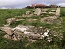
Webster, E., 2022, Military structures at Branscombe (Ground Photograph). SDV364706.
A ground photograph shows a scaffolded rectangular structure set back from low concrete footings. The scaffolded structure appears to be under renovation. Two upper storeys are square in plan, the uppermost storey with windows on three sides offering an ininterrupted view of the sea and coastline.
Sources / Further Reading
| SDV342938 | Aerial Photograph: Royal Air Force. 1946 - 1949. Royal Air Force Aerial Photographs. Royal Air Force Aerial Photograph. Photograph (Digital). |
| |
| | |
| SDV364674 | Cartographic: Ordnance Survey. 2022. Mastermap 2022. Ordnance Survey Digital Mapping. Digital. [Mapped feature: #136310 ] |
| |
| | |
| SDV364706 | Ground Photograph: Webster, E.. 2022. Military structures at Branscombe. Digital. |
| |  |
| | Linked images:2 |
| SDV364743 | Personal Comment: Horner, B.. 2022. Archaeological observation. Email. 22-FEB-2022. |
| |
| | |
Associated Monuments: none recorded
Associated Finds: none recorded
Associated Events: none recorded
| Date Last Edited: | Mar 23 2022 8:15PM |
|---|
Search results generated by the HBSMR Gateway from exeGesIS SDM Ltd.