See important
guidance on the use of this record.
If you have any comments or new information about this record, please email us.
| HER Number: | MDV21636 |
|---|
| Name: | Cove Bridge, Stoodleigh |
|---|
Summary
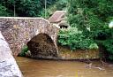
Elegant late 18th century road bridge over the River Exe with a tall segmental arch, the parapet rising to a low peak above it, and a small flood arch.
Location
| Grid Reference: | SS 948 197 |
|---|
| Map Sheet: | SS91NW |
|---|
| Admin Area | Devon |
|---|
| Civil Parish | Stoodleigh |
|---|
| Civil Parish | Tiverton |
|---|
| District | Mid Devon |
|---|
| Ecclesiastical Parish | TIVERTON |
|---|
Protected Status
Other References/Statuses
- Old DCC SMR Ref: SS91NW/57
- Old Listed Building Ref (II)
Monument Type(s) and Dates
- ROAD BRIDGE (Built, XVIII - 1790 AD (Between) to 1795 AD (Between))
Full description
Untitled Source (Migrated Record). SDV49659.
Dro=564/m/12/16-17(swetes devon tour)/illus.
Cove bridge. Vis=-/-/1796 (swete). "lately erected; a single-arched bridge, the old bridge was delapidated and "demolished about 3 years ago"
Untitled Source (Migrated Record). SDV49662.
Des=photo/dcc/film 107.
Department of Environment, 1959, Tiverton RD, 33 (List of Blds of Arch or Historic Interest). SDV54004.
Rubble with ashlar. One span with segmental arch. Erected 1761.
Department of Environment, 1972, Tiverton, 19 (List of Blds of Arch or Historic Interest). SDV52494.
1790. Replacing medieval bridge. Humped stone bridge with 2 semi circular arches, one large, one small.
Department of Environment, 1987, Stoodleigh, 105 (List of Blds of Arch or Historic Interest). SDV49663.
Road bridge over the River Exe. 1791 (old list description). Stone rubble. Elegant single-span bridge with a tall segmental arch with a keystone and a small flood arch. Small cutwater between main span and flood arch on the upstream side. Stone rubble parapets rise to a central peak. A handsome road bridge; group value with a thatched toll-house or cottage on the stoodleigh side of the river.
Child, P., 1998, Cove Bridge and Cove Cottage (Ground Photograph). SDV364924.
Photos of the bridge showing the main arch and the smaller flood arch.
Ordnance Survey, 2022, Mastermap 2022 (Cartographic). SDV364674.
Cove Bridge marked.
Sources / Further Reading
| SDV364674 | Cartographic: Ordnance Survey. 2022. Mastermap 2022. Ordnance Survey Digital Mapping. Digital. [Mapped feature: #138141 ] |
| |
| | |
| SDV364924 | Ground Photograph: Child, P.. 1998. Cove Bridge and Cove Cottage. Devon County Council Historic Buildings Photo. Photograph (Paper) + Digital. |
| |  |
| | Linked images:4 |
| SDV49659 | Migrated Record: |
| SDV49662 | Migrated Record: |
| SDV49663 | List of Blds of Arch or Historic Interest: Department of Environment. 1987. Stoodleigh. Historic Houses Register. Hard copy. 105. |
| |
| | |
| SDV52494 | List of Blds of Arch or Historic Interest: Department of Environment. 1972. Tiverton. Historic Houses Register. Unknown. 19. |
| |
| | |
| SDV54004 | List of Blds of Arch or Historic Interest: Department of Environment. 1959. Tiverton RD. Historic Houses Register. Unknown. 33. |
| |
| | |
Associated Monuments: none recorded
Associated Finds: none recorded
Associated Events: none recorded
| Date Last Edited: | Jul 22 2022 8:47AM |
|---|
Search results generated by the HBSMR Gateway from exeGesIS SDM Ltd.