See important
guidance on the use of this record.
If you have any comments or new information about this record, please email us.
| HER Number: | MDV58580 |
|---|
| Name: | Boundary Stone on Burley Down |
|---|
Summary
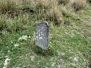
Boundary stone marked in this location on Ordnance Survey maps on 19th and 20th century maps. It was not located during a site visit in 1997 and it was suggested it may have been moved to the gateway onto Burley Down. However, a stone has been recently located circa 100 metres to the south-west of its original position. The initials suggest that the stone marks a land holding boundary rather than the parish boundary although the two coincide where the stone was originally located.
Location
| Grid Reference: | SX 490 869 |
|---|
| Map Sheet: | SX48NE |
|---|
| Admin Area | Devon |
|---|
| Civil Parish | Bridestowe |
|---|
| Civil Parish | Lewtrenchard |
|---|
| District | West Devon |
|---|
| Ecclesiastical Parish | LEWTRENCHARD |
|---|
| Ecclesiastical Parish | BRIDESTOWE |
|---|
Protected Status: none recorded
Other References/Statuses
- Old DCC SMR Ref: SX48NE/77/1
Monument Type(s) and Dates
- BOUNDARY STONE (Built, XVIII to XIX - 1701 AD to 1900 AD)
Full description
South West Heritage Trust, 1838-1848, Digitised Tithe Maps and Transcribed Apportionments (Cartographic). SDV359954.
The Bridestow and Lewtrenchard Tithe Apportionments record the landowners as Calmady Hamlyn to the north and Thomas Ham to the south.
Devon County Council, 1838-1848, Tithe Mosaic, approximately 1838-1848 (Cartographic). SDV349431.
Stone marked.
Ordnance Survey, 1880-1899, First Edition Ordnance 25 inch map (Cartographic). SDV336179.
'B.S.' shown.
Ordnance Survey, 1904 - 1906, Second Edition Ordnance Survey 25 inch Map (Cartographic). SDV325644.
Boundary stone shown.
Dyer, M. J. + Manning, P. T., 1988 - 1998, Objective 5B: Okehampton to Polson Bridge Recreation and Land Management Initiative: Cultural Heritage Appraisal, 30 (Report - Assessment). SDV266287.
Site visit on 25/11/1997. Boundary stone circa 250 metres to north-west of gate onto Burley Down, shown on late 19th and 20th century maps. Not located on site visit, possibly moved to left of gate, where there is a slate stone marked with 'G' on one side and 'H' on the other.
Ordnance Survey, 2009, MasterMap (Cartographic). SDV341569.
'Boundary Stone' shown.
Noakes, R., 2019, Boundary Stone (Ground Photograph). SDV363172.
Site visit 4th August 2019. The inscribed boundary stone is extant at SX4894 8689.
Sources / Further Reading
| SDV266287 | Report - Assessment: Dyer, M. J. + Manning, P. T.. 1988 - 1998. Objective 5B: Okehampton to Polson Bridge Recreation and Land Management Initiative: Cultural Heritage Appraisal. Exeter Archaeology Report. 98.01. A4 Grip Bound + Digital. 30. |
| |
| | |
| SDV325644 | Cartographic: Ordnance Survey. 1904 - 1906. Second Edition Ordnance Survey 25 inch Map. Second Edition Ordnance Survey 25 inch Map. Map (Digital). |
| |
| | |
| SDV336179 | Cartographic: Ordnance Survey. 1880-1899. First Edition Ordnance 25 inch map. First Edition Ordnance Survey 25 inch Map. Map (Digital). |
| |
| | |
| SDV341569 | Cartographic: Ordnance Survey. 2009. MasterMap. MasterMap. Digital. |
| |
| | |
| SDV349431 | Cartographic: Devon County Council. 1838-1848. Tithe Mosaic, approximately 1838-1848. Digitised Tithe Map. Digital. |
| |
| | |
| SDV359954 | Cartographic: South West Heritage Trust. 1838-1848. Digitised Tithe Maps and Transcribed Apportionments. Tithe Map and Apportionment. Digital. |
| |
| | |
| SDV363172 | Ground Photograph: Noakes, R.. 2019. Boundary Stone. Digital. |
| |  |
| | Linked images:2 |
Associated Monuments
| MDV58579 | Related to: Boundary Stone by Burley Down (Monument) |
| MDV126274 | Related to: Boundary stone on Burley Down, Lewtrenchard (Monument) |
Associated Finds: none recorded
Associated Events: none recorded
| Date Last Edited: | Aug 14 2019 10:31AM |
|---|
Search results generated by the HBSMR Gateway from exeGesIS SDM Ltd.