See important
guidance on the use of this record.
If you have any comments or new information about this record, please email us.
| HER Number: | MDV96213 |
|---|
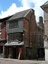
| Name: | 74 High Street, Barnstaple |
|---|
Summary
Early to mid 17th century house, now used as offices. Important as a rare example of early brickwork in Devon; the mixture of brick and jettied timber-framing is particularly remarkable and may be unique on the western side of England.
Location
| Grid Reference: | SS 557 332 |
|---|
| Map Sheet: | SS53SE |
|---|
| Admin Area | Devon |
|---|
| Civil Parish | Barnstaple |
|---|
| District | North Devon |
|---|
| Ecclesiastical Parish | BARNSTAPLE |
|---|
Protected Status
Other References/Statuses: none recorded
Monument Type(s) and Dates
- HOUSE (XVII to Modern - 1601 AD to 2013 AD (Between))
Full description
Watts, S., 19/05/2015, 74 High Street, Barnstaple (Ground Photograph). SDV358354.
Timms, S. C., 1976, The Devon Urban Survey, 1976. First Draft, 74 (Report - Survey). SDV341346.
Southwest Archaeology, 2013, Greater Barnstaple Area Project Database, BHBS Mapping Area 1055 (Un-published). SDV351581.
Ordnance Survey, 2013, MasterMap (Cartographic). SDV350786.
English Heritage, 2013, National Heritage List for England (National Heritage List for England). SDV350785.
74 High Street. House, now used as offices. Early or mid C17. Red brick in a rough English bond with thick mortar joints, the front wall being of timber-framing, jettied in the top storey; lower part of ground storey in right-hand side wall (facing Holland Walk) is of stone rubble, as is the left-hand side wall at the front. Rear part of this wall, visible from No.75 (qv), was of exposed brick in the upper storey, when first seen in 1967, but has since been rendered. The jettied front now has slatehanging in the 2nd storey with another panel of it in the middle of the right-hand side wall, this added when building restored in 1971. Slated roofs, the front roof parallel to street, the rear roof at right-angles. 2 large brick chimney-stacks in right-hand side wall each with a pair of diagonally set shafts on top. In 1967 the rear part of the left hand side wall had a similar stack with only one shaft; it is not known if this still exists.
Plan is one room wide and 2 rooms deep with stair compartment (for C19 stair) in the middle. A peculiarity is that the stair compartment and rear room are wider, projecting slightly into the back of the plot to No.75 (qv). 3 storeys, 1-window range; this was wholly reconstructed in 1971, except for the side walls. Shop in ground storey with part roof over, canted by a window in 2nd storey, 2 casement windows of 2 lights each in 3rd storey. The upper storey windows roughly resemble the C19 ones that were there in 1967, except that sashes have been replaced by casements. The timber-framing removed dated from C19, although there were ovolo-moulded uprights in the 2nd storey, probably belonging to an oriel window; these may still be in position, plastered in. 3rd-storey jetty is supported on the right by a concrete corbel; it replaced one described as `a sham fabricated out of pieces of wood'. On the left is a large stone corbel composed of 2 sandstone and 1 limestone blocks, all 3 ovolo-moulded. The walling above it was rebuilt in 1971. Front to Holland Walk is dominated by the 2 large chimneys; upper-storey windows and display window in ground storey are all of 1971.
Interior: has old floor and roof timbers; fireplaces with plain wood lintels.
Historical Note: the title deeds extend back to 1674. No.74 was `the landes of William Sallisbury and Nicholas Cutlief' in 1617, and in 1674 it was sold by Elizabeth and Mary Stephens, spinsters, to Thomas Harris of Barnstaple, tanner. The actual occupant in 1674 was their tenant, William Bond, who was succeeded later in the C17 by William Allen. By 1773 it was known as the Three Cupps. The building is important as a rare example of early brickwork in Devon; the mixture of brick and jettied timber-framing is particularly remarkable and may be unique on the western side of England.
Sources / Further Reading
| SDV341346 | Report - Survey: Timms, S. C.. 1976. The Devon Urban Survey, 1976. First Draft. Devon Committee for Rescue Archaeology Report. A4 Unbound + Digital. 74. |
| |
| | |
| SDV350785 | National Heritage List for England: English Heritage. 2013. National Heritage List for England. Historic Houses Register. Digital. |
| |
| | |
| SDV350786 | Cartographic: Ordnance Survey. 2013. MasterMap. Ordnance Survey Digital Mapping. Digital. [Mapped feature: #110057 ] |
| |
| | |
| SDV351581 | Un-published: Southwest Archaeology. 2013. Greater Barnstaple Area Project Database. Greater Barnstaple Area Project. Digital. BHBS Mapping Area 1055. |
| |
| | |
| SDV358354 | Ground Photograph: Watts, S.. 19/05/2015. 74 High Street, Barnstaple. Digital. |
| |  |
| | Linked images:1 |
Associated Monuments: none recorded
Associated Finds: none recorded
Associated Events: none recorded
| Date Last Edited: | May 20 2015 4:31PM |
|---|
Search results generated by the HBSMR Gateway from exeGesIS SDM Ltd.