If you think this information is inaccurate please e-mail corrections to
Hertfordshire HER
.
| HHER Number: | 15185 |
|---|
| Type of record: | Building |
|---|
| Name: | TIMBER FARM BUILDINGS AT LAMER HOUSE, GUSTARDWOOD, WHEATHAMPSTEAD |
|---|
Summary
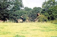
Barn and possible stable at Lamers
Images
 No image caption available © Hertfordshire County Council |  No image caption available © Hertfordshire County Council |
Monument Types
- OUTBUILDING (Undated)
- TIMBER FRAMED BARN (Post Medieval - 1501 AD to 1900 AD)
Associated Events
- Hertfordshire timber farm buildings survey, 2002
Full description
Barn and outbuildings. Open barn with timber posts and corrugated iron covering. Outbuilding maybe weatherboarded to the west of barn. Small L-shape building to the south, may be a stable block. Map shows further buildings to the west <1>. For the country house, see [9519].
The mid 19th century home farm was at the south end of the park; see [30274].
<1> Wilcox, Sallianne, 2002, Hertfordshire timber farm buildings survey: Dacorum District: Great Gaddesden, Nettleden with Potten End; St Albans District: Wheathampstead, Sandridge, Harpenden, Farm 330, site visit 21/8/02 (Unpublished document). SHT16691.
Sources and further reading
| <1> | Unpublished document: Wilcox, Sallianne. 2002. Hertfordshire timber farm buildings survey: Dacorum District: Great Gaddesden, Nettleden with Potten End; St Albans District: Wheathampstead, Sandridge, Harpenden. Farm 330, site visit 21/8/02. |
Search results generated by the HBSMR Gateway from exeGesIS SDM Ltd.