If you think this information is inaccurate please e-mail corrections to
Hertfordshire HER
.
| HHER Number: | 6934 |
|---|
| Type of record: | Building |
|---|
| Name: | PILLBOX, TRAFFIC CONTROL BARRIER AND LIGHT TOWER, ALLEN'S GREEN AIRFIELD W |
|---|
Summary - not yet available
Images
 No image caption available © Hertfordshire County Council |  No image caption available © Hertfordshire County Council |
 No image caption available © Hertfordshire County Council | |
Monument Types
- PILLBOX (World War II - 1939 AD to 1945 AD)
Protected Status
- Scheduled Ancient Monument 32451
- Sensitivity Map: allens green airfield defences
Full description
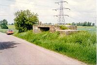
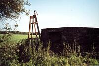
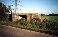
A hexagonal, brick and concrete (most of the brick has fallen off), 21' diameter pillbox standing by the N side of the road half a mile to the W of Blount's Farm. Like most of the Hunsdon and Allen's Green pillboxes it is massively built with a 10' 6" x 5' 6" rectangular entrance. However, this pillbox has an unusual feature - there are only two gun apertures, facing NW and SE along the road. Alongside, to the NW is a metal structure, 7' high, 4 legs, possibly the remains of a light tower <1>. This has been uprooted (including its concrete base) from its original location and left here. It has remains of electrical wiring and probably provided lightfor the control barrier at night. 120 yards to the west <2>, on the northern side of Parsonage Lane is an adjacent stanchion, which originally supported a wooden road barrier <3>.
<1> Fred Nash (HCC), site visit and photographs, 3.6.1992 (Unpublished document). SHT3718.
<2> Nash, F & Tyler, S Hertfordshire County Council, Allen's Green (RAF Sawbridgeworth) SMR Updates November 2001 (Bibliographic reference). SHT7275.
<3> Scheduled Monument description, 18.3.2004 (Scheduling record). SHT9990.
Sources and further reading
| <1> | Unpublished document: Fred Nash (HCC), site visit and photographs. 3.6.1992. |
| <2> | Bibliographic reference: Nash, F & Tyler, S Hertfordshire County Council, Allen's Green (RAF Sawbridgeworth) SMR Updates November 2001. |
| <3> | Scheduling record: Scheduled Monument description. 18.3.2004. |
Related records
| 10133 | Part of: ALLEN'S GREEN (SAWBRIDGEWORTH) AERODROME, HIGH WYCH (Monument) |
Search results generated by the HBSMR Gateway from exeGesIS SDM Ltd.