If you think this information is inaccurate please e-mail corrections to
Hertfordshire HER
.
| HHER Number: | 6942 |
|---|
| Type of record: | Building |
|---|
| Name: | BATTLE HEADQUARTERS, ALLEN'S GREEN AIRFIELD EAST |
|---|
Summary - not yet available
Images
 No image caption available © Hertfordshire County Council |  No image caption available © Hertfordshire County Council |
 No image caption available © Hertfordshire County Council |  No image caption available © Hertfordshire County Council |
 No image caption available © Hertfordshire County Council | |
Monument Types
- BATTLE HEADQUARTERS (Twentieth Century - 1901 AD to 2000 AD)
Protected Status
- Sensitivity Map: allen's green airfield and deer park
- Scheduled Ancient Monument 32451-08: RAF SAWBRIDGEWORTH WORLD WAR II AIRFIELD DEFENCES
- Scheduled Ancient Monument 32451
- SHINE: WW2 Air Defences,medieval moat & ph earthworks in and surrounding Mathams Wood
Full description
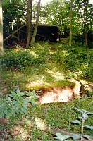
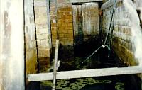
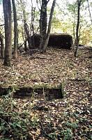
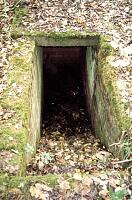
Following almost exactly the same design and layout as the complex at Hunsdon Airfield [6931], the Battle Headquarters of Allen's Green Airfield. A 9' square, 2'6" thick concrete roof sitting, with just a 2" gap, on massive concrete walls. The narrowness of the gap suggests that the bunker was probably intended for observation and control rather than defence particularly as the pillbox at TL 4639 1824 [6941] is just 30 yards distant. Entrance is via a vertical manhole or a flight of steps, 20' to the W <1>. The structure is largely subterranean and only the lookout post projects above ground. This has a 360 degree observation slit and a signal mortar tube in its roof. The HQ consists of five rooms: sleeping quarters, mess, office, lobby and latrine <3>. The interior was seen to be flooded during site visits in 1992 and 2001 <2>.
A photocopy of RAF aerial photos from 1948 and 1952, and plans of the airfield and battlefield HQ and dispersal pen types can be found in the EH scheduling proposal SM 32451 <4>.
<1> Fred Nash (HCC), site visit and photographs, 9.6.1992 (Unpublished document). SHT3718.
<2> Nash, F & Tyler, S Hertfordshire County Council, Allen's Green (RAF Sawbridgeworth) SMR Updates November 2001 (Bibliographic reference). SHT7275.
<3> Scheduled Monument description, 18.3.2004 (Scheduling record). SHT9990.
<4> EH schedule proposal folder (Bibliographic reference). SHT3140.
Sources and further reading
| <1> | Unpublished document: Fred Nash (HCC), site visit and photographs. 9.6.1992. |
| <2> | Bibliographic reference: Nash, F & Tyler, S Hertfordshire County Council, Allen's Green (RAF Sawbridgeworth) SMR Updates November 2001. |
| <3> | Scheduling record: Scheduled Monument description. 18.3.2004. |
| <4> | Bibliographic reference: EH schedule proposal folder. |
Related records
| 10133 | Part of: ALLEN'S GREEN (SAWBRIDGEWORTH) AERODROME, HIGH WYCH (Monument) |
Search results generated by the HBSMR Gateway from exeGesIS SDM Ltd.