If you think this information is inaccurate please e-mail corrections to
Hertfordshire HER
.
| HHER Number: | 6998 |
|---|
| Type of record: | Building |
|---|
| Name: | AIRCRAFT DISPERSAL PEN, ALLEN'S GREEN AIRFIELD N |
|---|
Summary - not yet available
Images
 No image caption available © Hertfordshire County Council |  No image caption available © Hertfordshire County Council |
Monument Types
- AIR RAID SHELTER (Twentieth Century - 1901 AD to 2000 AD)
- BLAST PEN (Twentieth Century - 1901 AD to 2000 AD)
- DISPERSAL (Twentieth Century - 1901 AD to 2000 AD)
Protected Status
- Scheduled Ancient Monument 32451-08: RAF SAWBRIDGEWORTH WORLD WAR II AIRFIELD DEFENCES
- Area of Archaeological Significance
- Scheduled Ancient Monument 32451
- SHINE: WW2 Air Defences,medieval moat & ph earthworks in and surrounding Mathams Wood
Full description
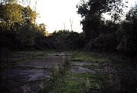
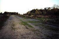
Built on the N edge of Mathams Wood, the two part, earth and grass covered structure now stands in isolation. As at [6997], access to the interior is via two brick-lined entrances on the N side, but in this instance the two roads or taxiways linking the structure with the airfield perimeter track survive<1, 2>. This is one of four dispersal pens to survive at the airfield (see also [6997, 6998, 6999]) out of a total of thirteen <5>. It is approximately 25m wide and shaped in a crescent 'E'. The foundation walls at the base of the soil banking survive although the eastern arm has since been shortened. The shelter at the junction of the two arms also survives <3>.
<1> Stewart Bryant (HCC), Information, Site visit with KAT, March 1996 (Verbal communication). SHT5002.
<2> OS 1:2500 & 1:10000 maps (Cartographic material). SHT7911.
<3> Nash, F & Tyler, S Hertfordshire County Council, Allen's Green (RAF Sawbridgeworth) SMR Updates November 2001 (Bibliographic reference). SHT7275.
<4> Scheduled Monument description, 18.3.04 (Scheduling record). SHT9990.
<5> EH schedule proposal folder, Plans of airfield, RAF photos etc (Bibliographic reference). SHT3140.
Sources and further reading
| <1> | Verbal communication: Stewart Bryant (HCC). Information. Site visit with KAT, March 1996. |
| <2> | Cartographic material: OS 1:2500 & 1:10000 maps. |
| <3> | Bibliographic reference: Nash, F & Tyler, S Hertfordshire County Council, Allen's Green (RAF Sawbridgeworth) SMR Updates November 2001. |
| <4> | Scheduling record: Scheduled Monument description. 18.3.04. |
| <5> | Bibliographic reference: EH schedule proposal folder. Plans of airfield, RAF photos etc. |
Related records
| 10133 | Part of: ALLEN'S GREEN (SAWBRIDGEWORTH) AERODROME, HIGH WYCH (Monument) |
Search results generated by the HBSMR Gateway from exeGesIS SDM Ltd.