If you have any feedback or new information about this record, please email the Southampton HER (her@southampton.gov.uk).
Data derived from Heritage Gateway will not be acceptable for any use associated with development proposals and other planning matters.
For important guidance on the use of this record, please click
here
. © Southampton City Council
Summary
The building currently known as Tower House. The land now occupied by Tower House and Solent House (to the west) was a vacant plot in 1454, against the inside of the southern town wall. By 1617 there were three stables on the plot, possibly of medieval date. The present buildings must have been at least partly built after the demolition of the town wall in c1803/4; there is a date stone of 1822 in the wall of Solent House. However the property boundary between the two buildings probably pre-dates the demolition of the town wall, and the present buildings may incorporate earlier remains. Sometime after 1810 both sites became part of the Bridewell; this closed in 1854-55. Historic maps may suggest that Tower House was partly rebuilt between 1846 and 1870. The building is currently used as an office by Southampton City Council's Arts and Heritage department (2009).
Protected Status
- Listed Building (II) 1179250: TOWER HOUSE
- Conservation Area: Old Town South
Other References/Statuses
- Old Southampton SMR No/Backup file: SU 4210 NW 29 Also SU 4210 NW 17; also SU 4210 NW 20
Monument Type(s):
Full description
[4]: Listed Building Description. TOWN QUAY - Tower House (Grade II).
- Mainly C19 probably incorporating part of an earlier C18 building. Three storeys built of stone rubble with tiled roof. Red brick window dressings. Castellated parapet raised up in the centre with a shield. Three sashes with vertical glazing bars only. The ground floor projects and is castellated with a further projecting porch. This building is thought to have been used as the town mortuary as it was adjacent to the Gaol.
[Derived from English Heritage LBS download dated 19/08/2005. Crown Copyright. Reproduced under the terms of the Open Government Licence.]
[3]: Summary of documentary evidence (see 1.3.3 for full details).
The plots of Solent House and Tower House were vacant in 1454 but by 1617 there were three stables on the combined plots, possibly of medieval date. The later documentary references for the sites have not been carefully examined but the present property boundary probably dates to before the 19th century, and an examination of the above-ground wall faces tends to support this. The back walls of the two buildings are clearly of different design, and the present property boundary is reflected also in the lower parts of the above-ground walls, at offset level; the relationship between the respective below-ground walls is not known due to later disturbance. Both sites were used as part of the Bridewell in the 19th century (sometime after 1810). A date stone of 1822 in the wall of Solent House, with the initials of the Mayor of Southampton at that date (Russel AD, pers comm), may date alterations associated with its conversion to the Bridewell*.
* Or be the construction date. SCC HER 22/12/09.
The 1771 map [5] shows the town wall lapped by the sea in this area. The town wall was probably demolished in about 1803/4, when Watergate was demolished (see MSH33). Sometime after 1810 the town's Bridewell, which had been established over God's House Gate in 1707, expanded to include "Solent Cottage and Platform House" [7], presumably what are now called Tower House and Solent House respectively. (There was a gaol for felons and debtors in Gods House Tower [7].) The 1846 map [6] shows these buildings along with Gods House Tower and Gate as "Gaol"; a yard and buildings protrude to the south of the present building line. The main buildings on the 1846 map appear to be on a slightly different footprint to the current Tower House, whereas the1870 map [8] shows a footprint like that of Tower House. The building may therefore have been partly rebuilt between 1846 and 1870. The gaol and bridewell were abandoned when a larger gaol was built elsewhere in 1854-55 [7].
[1]: Documentary summary (page 3). The 1611 map shows the town wall running through what are now Tower House and Solent House. The present buildings seem mostly to have been built after the demolition of the town wall.
SOU 570 results:
[1]: Part of the west face of the dividing wall between Tower House and Solent House was recorded (wall 2); it was built of roughly coursed limestone rubble. An opening (feature 44) had been cut through this wall into a stone culvert beneath Tower House (for which see separate record - IP). An entrance pit (walls 9 and 22) had been constructed in Solent House, leading through the opening in the wall, into the culvert. The construction around the opening appeared to be of post-medieval or early modern date, altered in the early modern or modern period; it was not clear whether it was a new opening or a replacement for an earlier structure. In the north wall of Tower House and Solent House was a retaining arch (arch 39), built between the stone culvert and a stone-vaulted structure under Winkle Street (see separate record - IP). The arch was 1.6m wide and 0.35m thick and was built of carefully dressed fine-grained limestone voussoirs, of a neater build than the stone culvert and vault; the southern side of the arch was recorded. The arch had probably been built to support the north wall of the two buildings.
SOU 594 results:
[2]: Two small trenches were dug outside Tower House, either side of the porch. The porch is a late-19th century addition, and its foundations were found to be shallow. Linear features were found, at least one of which predates the present porch/south wall of Tower House, and may be associated with the early 19th century town gaol. The lowest context exposed in both trenches was a gravel layer; its level, at c3.3mOD suggests that it was redeposited at an unknown date, rather than being natural.
SOU 802 results:
[3]: The stone foundations of the west end of the north wall of Tower House were revealed (wall 10). They were undated but could be medieval. (See report for full description.)
SOU 1151 (building recording of a blocked doorway at Tower House/Solent House in 2001):
HER 1/9/2015: A blocked doorway to the right of the main entrance door to Tower House/Solent House on Town Quay was recorded, prior to the proposed opening up of the doorway. Although a planning application was submitted in 2003 for that work, it was never carried out. (See event record for further details.)
Sources / Further Reading
| --- | SSH3093 - Unpublished document: Ancient Monument File AM41 - Winkle Street. |
| --- | SSH3243 - Unpublished document: K McArdle. 1992. Condition Survey of Heritage Properties and Planned Maintenance Survey - Solent House/Tower House, Town Quay, Southampton.. |
| [1] | SSH193 - Archaeological Report: B Shuttleworth. 1994. Report on the Watching Brief carried out at Tower House/Solent House, Southampton.. SOU 570. pp 3, 4,5,7 etc |
| [2] | SSH44 - Archaeological Report: MF Garner. 1994. Report on the Excavation of two Test Pits, Tower House, Southampton.. SOU 594. All |
| [3] | SSH352 - Archaeological Report: I Peckham. 1997. Watching Brief on groundworks for the repaving of Winkle Street, Southampton. SOU 802. p 6/7/8, 22-24, p26-27, p47 |
| [4] | SSH2888 - Digital archive: English Heritage. 2005. Listed Buildings System dataset for Southampton. |
| [5] | SSH921 - Map: P Mazell. 1771. A Plan of Southampton and of the Polygon 1771. Paper. |
| [6] | SSH679 - Map: Campbell/Yolland/Royal Engineers. 1846. Plan of the Borough of Southampton surveyed in 1845-6.. Paper. |
| [7] | SSH664 - Bibliographic reference: JS Davies. 1883. A History of Southampton. pp 101-2 |
| [8] | SSH977 - Map: Ordnance Survey. 1870. OS 1870 1:500 series (Sometimes referred to as the 1868 map). Paper. 1:500. |
Associated Finds: None recorded
Associated Events
- ESH1151 - Building recording at Tower House/Solent House, Town Quay Road in 2001 (Ref: SOU 1151)
- ESH1963 - Condition survey and planned maintenance survey of Solent House and Tower House, Town Quay in 1992
- ESH570 - Watching Brief at Tower House/Solent House in 1994 (Ref: SOU 570)
- ESH594 - Excavations at Tower House, Town Quay Road in 1994 (Ref: SOU 594)
- ESH802 - Watching brief on Winkle Street Repaving in 1997 (Ref: SOU 802)
Related records
| MSH71 | Peer (Chronological): Stone-vaulted Structure at east end of Winkle Street |
| MSH1086 | Peer (Chronological): Tower House/Solent House - Stone Culvert |
| MSH33 | Peer (Chronological): Town Defences - town wall (demolished) between God's House Tower and Notebeem Tower/Notebeme Tower |
Associated Links: None recorded
Images
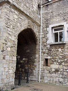
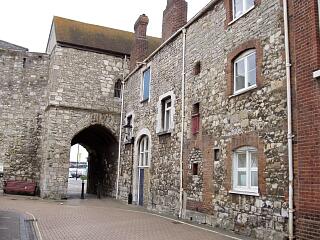 God's House Gate, Tower House and Solent House, Winkle Street, 30.8.09 (camera date not set), © I Peckham | 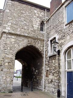 God's House Gate, Winkle Street, 30.8.09 (camera date not set), © I Peckham |
 God's House Gate, Winkle Street, 30.8.09 (camera date not set), © I Peckham | 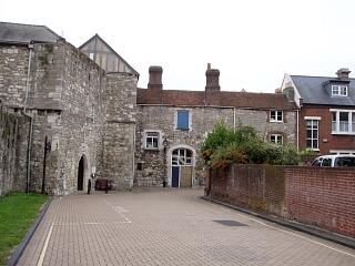 God's House Gate, God's House Tower and town wall, Back of the Walls, 30.8.09 (camera date not set), © I Peckham |
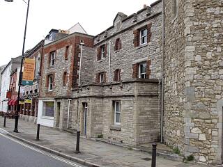 God's House Gate, Tower House and Solent House, Town Quay, 30.8.09 (camera date not set), © I Peckham | 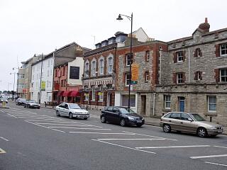 Tower House, Solent House and other buildings, Town Quay, 30.8.09 (camera date not set), © I Peckham |
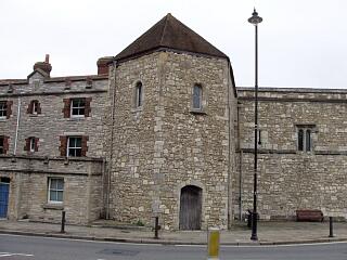 God's House Gate, God's House Tower and Tower House, Town Quay, 30.8.09 (camera date not set), © I Peckham | 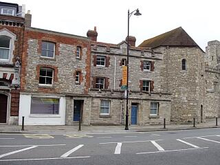 God's House Gate, Tower House and Solent House, Town Quay, 30.8.09 (camera date not set), © I Peckham |
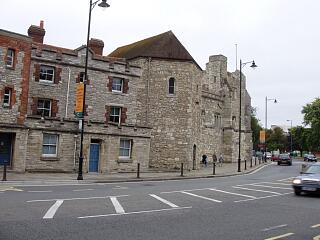 God's House Gate, God's House Tower and Tower House, Town Quay, 30.8.09 (camera date not set), © I Peckham | 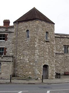 God's House Gate, Town Quay, 30.8.09 (camera date not set), © I Peckham |
If you have any feedback or new information about this record, please email the Southampton HER (her@southampton.gov.uk).
Search results generated by the HBSMR Gateway from exeGesIS SDM Ltd.