If you have any feedback or new information about this record, please email the Southampton HER (her@southampton.gov.uk).
Data derived from Heritage Gateway will not be acceptable for any use associated with development proposals and other planning matters.
For important guidance on the use of this record, please click
here
. © Southampton City Council
| HER Number: | MSH219 |
|---|
| Type of Record: | Monument |
|---|
| Name: | Town Defences - site of fifth tower south of East Gate |
|---|
| Grid Reference: | SU 4213 1121 |
|---|
| Map: | Show location on Streetmap |
|---|
Summary
A now-demolished medieval tower on the eastern town wall, the fifth tower south of East Gate. In 1454 it had three defensive loops. In 1805 Englefield described it as semi-circular, and it may have had a surviving loop, or loops - an arrow loop converted to gun loop. However late 18th century maps show it as rectangular. The tower had been demolished by 1846.
The date of the eastern town wall and towers is uncertain. Much of this stretch of wall could be broadly contemporary with the northern town wall, so of late 13th century date (1260 to 1291), however a mid-14th century or later date has also been proposed.
Parts of the tower may have been found on SOU 329.
Protected Status: None recorded
Other Statuses/Codes: None Recorded
Monument Type(s):
Full description
Records for the town defences are currently being enhanced and it is intended that further details will be added to this description at a later date. (SCC HER 4/12/09)
------------------------------------------
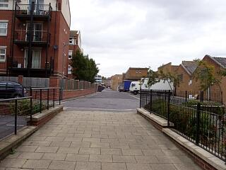
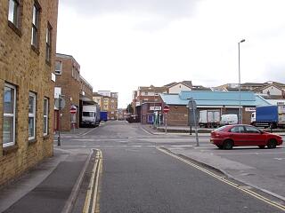
IP 20/12/02: The site of a tower, along the line of the demolished town wall, is shown on the 1966 OS map in Back of the Walls, between Briton Street and Bernard Street. No further details available. Parts of this tower are thought to have been observed in 1988 in a trench on Back of the Walls (SOU 329) [2][3][4] (see child record).
Sources / Further Reading
| [1] | SSH995 - Map: Ordnance Survey. 1966. OS SU 4211 SW 1966. Paper & digital. 1:1250. |
| [2] | SSH871 - Serial: The Society for Medieval Archaeology. 1989. Medieval Archaeology, Vol 33, 1989 (for 1988). p 193 |
| [3] | SSH869 - Serial: M Hughes (ed), Hampshire County Council. 1989. Archaeology in Hampshire Annual Report for 1988. p 26 |
| [4] | SSH521 - Serial: Morton, AD (ed), SCC. 1991. Annual Report of the Southampton Archaeological & Heritage Management Section for 1990-1991. p 32 |
Associated Finds: None recorded
Associated Events: None recorded
Related records
| MSH14 | Child of: Town Defences - town wall, towers and gates |
| MSH1347 | Parent of: Back of the Walls - Stone Walls |
Associated Links: None recorded
Images
 Line of demolished east town wall along Back of the Walls, north of Briton Street, looking north, 6/9/09, © I Peckham |  Line of demolished east town wall along Back of the Walls, looking south, 6/9/09, © I Peckham |
If you have any feedback or new information about this record, please email the Southampton HER (her@southampton.gov.uk).
Search results generated by the HBSMR Gateway from exeGesIS SDM Ltd.