If you have any feedback or new information about this record, please email the Southampton HER (her@southampton.gov.uk).
Data derived from Heritage Gateway will not be acceptable for any use associated with development proposals and other planning matters.
For important guidance on the use of this record, please click
here
. © Southampton City Council
| HER Number: | MSH3420 |
|---|
| Type of Record: | Monument |
|---|
| Name: | Southampton Castle - south curtain wall (standing and demolished sections) |
|---|
| Grid Reference: | SU 4186 1141 |
|---|
| Map: | Show location on Streetmap |
|---|
Summary
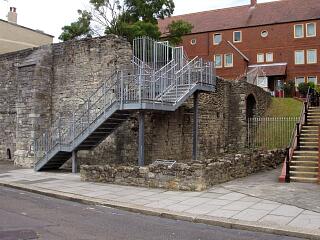
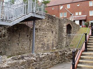
Part of the south bailey/curtain wall survives above-ground at the south-west corner of the Southampton Castle site. This wall was investigated during archaeological work in 1973/1974 and after (SOU 123/SOU 116). Below-ground remains of the wall were traced eastwards as far as the limit of excavation on the west side of Upper Bugle Street. It is not known whether the bailey wall continued up or around the motte. At the west end, the south bailey wall is continued as the south wall of Castle Hall. The south bailey wall and Castle Hall are both dated to the late 11th century, or (more likely) the early-to-mid 12th century. The above-ground remains are scheduled.
Protected Status
- Scheduled Monument 1001889: Castle (part of), Western Esplanade
Other Statuses/Codes: None Recorded
Monument Type(s):
- CASTLE (Medieval to Post Medieval - 1066 AD? to 1618 AD)
- CURTAIN WALL (Built, Medieval - 1066 AD? to 1155 AD?)
Full description
See Parent Record MSH23 for a summary of the documentary and excavation evidence for Southampton Castle, a discussion of the development of the Castle derived largely from [1], and a full list of sources. (References given in chronological order.)
-----------------------------------------------------
[5]: 1846 map. Parish boundary follows this wall (outer edge?) for some distance before turning southwards.
[6]: 1870 map. “Castle Wall” shown behind houses from westside of Castle Lane almost as far as the west wall. “Ward boundary” follows the outer/south edge of this wall and continues more-or-less straight towards the motte area.
[7]: Davies, 1883. Describing the line of the curtain wall. “The castle wall ....turned nearly due east, portions of it still existing behind the houses on the south of Castle Gardens. At about 110 feet from the south-west angle it crossed Castle Lane (south). Here was the south gate of the baily, demolished about 1770. Beyond this the wall continued eastward some 40 feet till it struck the lofty mound of the keep .....”
[8]: VCH, 1908. (Largely derived from [7].) South wall – recently exposed.
SOU 123 (UBS II) and part of SOU 116 (excavations and watching briefs in 1973/1974 and after):
[1] in [2]: The area around the standing section of the south bailey wall was investigated, and it was traced eastwards below-ground as far the limit of excavation on the west side of Upper Bugle Street.
_ ?Late 11th/early 12th century: South bailey wall (curtain wall) with some evidence of early gate. The wall may have been built against a natural scarp (cliff) or the natural gravels were cut back and the wall built against the resulting face. At the west end, the south bailey wall is continued as the south wall of Castle Hall. The bailey wall, Castle Hall and a small garderobe (Garderobe 1) in the angle between the two, represent a single period of construction. At the east end of the site the wall cut across part of the motte ditch; the ditch fills had apparently accumulated against the wall. The motte ditch was not observed south of the bailey wall (presumably because the area was not investigated - SCC HER).
_ Late 14th century: Stone wall, possibly the remnants of a gateway in the south bailey wall.
_ 16th to 18th century: Partial demolition, collapse, infilling and levelling of area.
(See also earlier reports [3][4] for SOU 123/SOU 116.)
[2] (concluding chapters): There was no ditch associated with the south wall.
SCC HER: This wall has been traced by archaeological excavation as far as the west side of Upper Bugle Street, where it was seen to be descending into the motte ditch. It is not known whether it ever continued up the side of the motte to the keep. Davies [7] is describing what may have been a wall at the foot of the motte, although this may be post-medieval (see elsewhere).
[9]: 1981 correspondance about damage to part of the south curtain wall (a scheduled monument) during construction work (see source for details).
GIS: Digitised as three sections - the standing remains at the west end, the part exposed on SOU 123, and its conjectural continuation to the east. SCC HER 19/11/09
Sources / Further Reading
| --- | SSH6080 - Unpublished document: Southampton City Council (City Architect and City Treasurer). 1980. Leisure Committee report - 2 July 1980 (etc): Castle remains, Upper Bugle Street - Public Access Layout.. |
| --- | SSH6081 - Unpublished document: ?1980. Castle Remains, Upper Bugle Street (photocopies of set of photos).. |
| --- | SSH6082 - Unpublished document: ?1980. Annotated copy of plan of Castle Remains, Upper Bugle Street excavations.. |
| [1] | SSH1943 - Article in monograph: DF Devereux. 1986. SOU 123 (Upper Bugle Street Phase II).. Oxley, 1986: Excavs at Soton Castle. all (pp 16 - 38, figure 1) |
| [2] | SSH516 - Monograph: J Oxley (ed). 1986. Excavations at Southampton Castle. Southampton Archaeological Monograph 3. |
| [3] | SSH925 - Serial: SARC. 1974?. Southampton Archaeological Research Committee Annual Report for 1973-4. pp 13 - 17, figure 9 (p 26). |
| [4] | SSH1161 - Serial: M Hughes (ed), Hampshire County Council. 1981. Archaeology in Hampshire Annual Report for 1980. p 25 |
| [5] | SSH679 - Map: Campbell/Yolland/Royal Engineers. 1846. Plan of the Borough of Southampton surveyed in 1845-6.. Paper. |
| [6] | SSH977 - Map: Ordnance Survey. 1870. OS 1870 1:500 series (Sometimes referred to as the 1868 map). Paper. 1:500. |
| [7] | SSH664 - Bibliographic reference: JS Davies. 1883. A History of Southampton. pp 74-75 |
| [8] | SSH634 - Bibliographic reference: 1908. Victoria County History Hants Volume 3 (1908). 3. p 498 |
| [9] | SSH4300 - Written communication: Department of the Environment & Southampton City Planning Officer. 1981. Memos & letters concerning damage to the south curtain wall of Southampton Castle (Scheduled Ancient Monument 242). |
Associated Finds: None recorded
Associated Events
- ESH123 - Excavations in Upper Bugle Street and the Southampton Castle Site in 1973/1974 (UBS II) (Ref: SOU 123)
- ESH1553 - Drawn Survey of walls at Castle Hall and Watergate Passage in 1983/1984 (Ref: SOU 116)
Related records
| MSH23 | Child of: Former Southampton Castle |
Associated Links: None recorded
Images
 Castle Hall, Castle Garderobe and remains of south town wall, Western Esplanade, 21.6.09, © I Peckham |  South wall of Castle Hall, Castle Garderobe and remains of south town wall, from Western Esplanade, 21.6.09, © I Peckham |
If you have any feedback or new information about this record, please email the Southampton HER (her@southampton.gov.uk).
Search results generated by the HBSMR Gateway from exeGesIS SDM Ltd.