If you have any feedback or new information about this record, please email the Southampton HER (her@southampton.gov.uk).
Data derived from Heritage Gateway will not be acceptable for any use associated with development proposals and other planning matters.
For important guidance on the use of this record, please click
here
. © Southampton City Council
| HER Number: | MSH43 |
|---|
| Type of Record: | Monument |
|---|
| Name: | Town Defences - town wall (demolished) between Water Gate and Notebeem Tower/Notebeme Tower |
|---|
| Grid Reference: | SU 4198 1095 |
|---|
| Map: | Show location on Streetmap |
|---|
Summary
The section of the southern town wall between Watergate and Notebeme Tower (Watch Tower) was probably built between 1321 and 1341, most likely after 1339 and contemporary with the gate and tower. The wall ran due south from the east side of Watergate, forming a salient that protected the gate. After some distance it turned south-east and continued on a WNW/ESE alignment to Notebeme Tower. Towards the north end of the wall, near Watergate, a stair lead up onto the wall-walk of the town wall; this gave access to Notebeme Tower. Some late 18th century illustrations may still show the part of the wall adjacent to the gate, although by then buildings had been constructed against both sides of the wall. In 1789 a postern was ordered to be constructed at Watergate; this may have been in the town wall just south-east of the gate, or in the west tower of the gate. Not long after, buildings adjoining the east side of Watergate, and perhaps also part of the town wall, were demolished. Certainly, the rest of the town wall was demolished in 1803/4. The demolition allowed the removal of the former kink at the west end of Winkle Street, opening up the route along Winkle Street from Gods House Gate to Town Quay. Parts of the foundations of the WNW/ESE aligned section of wall were exposed during archaeological work in 1989 (SOU 396 Trench 7), 1993 (SOU 545 Trench 2) and 1994/6 (SOUs 607 and 715). On SOU 545, the wall had a battered foundation similar to that of the town wall (MSH3134) incorporated into the rectangular extension of the Watergate drum tower.
Protected Status: None recorded
Other References/Statuses
- Old Southampton SMR No/Backup file: SU 4210 NW 21 Also SU 4110 NE 17
Monument Type(s):
Full description
Records for the town defences are currently being enhanced and it is intended that further details will be added to this description at a later date. (SCC HER 4/12/09)
-----------------------------------------------------------
[1][2]: On SOU 607 T3 and SOU 715 T6 and T7, part of the section of the medieval town wall lying between Water Gate and ?Notebeem Tower was found. It is thought likely that this is the same wall found further to the west on SOU 545 T2 (for which see child record - IP). The evidence from SOU 607, SOU 715 and probably also SOU 545 indicates that the town wall did not run straight between the Water Gate and the tower to the southeast, as suggested by Speed's 1611 map. There must be a change in alignment to the wall just to the west of SOU 545 T2.
(GIS: polygon very roughly plotted showing the entire section of the town wall, following the interpretation/figures in [2], and Mazell map of 1771. IP 12/4/02.)
Sources / Further Reading
| --- | SSH3083 - Unpublished document: Ancient Monument File AM31 - Watergate/Water Gate. |
| --- | SSH3103 - Unpublished document: Ancient Monument File AM50 - Views: Distances and Shores, etc. |
| [1] | SSH219 - Archaeological Report: MF Garner. 1995. Report on the Surveys and Evaluation Excavation at the Sun Public House, Southampton.. SOU 607. All |
| [2] | SSH274 - Archaeological Report: MF Garner. 1996. Excavation and Watching Brief at 84 High Street, Southampton. SOU 715. All |
| [3] | SSH591 - Serial: Morton, AD (ed), SCC. 1995. Archaeological Investigations in Southampton for 1994. ? |
| [4] | SSH557 - Archaeological Report: G Bareham. 1994. Watching Brief on a Gas Pipe Trench at the Junction of Town Quay and the High Street, Southampton (SOU 545 Trench 2).. SOU 545. |
Associated Finds: None recorded
Associated Events
- ESH1207 - Evaluation excavation at the Sun Public House in 1994 (Ref: SOU 607)
- ESH715 - Excavation and watching brief prior to building of Notebeme House in 1995-6 (Ref: SOU 715)
Related records
| MSH14 | Child of: Town Defences - town wall, towers and gates |
| MSH612 | Parent of: Stone Wall at junction between High Street and Town Quay |
| MSH661 | Parent of: Town Quay Road - Stone Wall |
| MSH626 | Peer (Chronological): 84 High Street - 19th Century Phase (Sun Inn, Sun Public House) |
| MSH625 | Peer (Chronological): 84 High Street - Other Medieval Evidence |
| MSH1090 | Peer (Chronological): 84 High Street - Phase Pre-dating the Town Defences |
Associated Links: None recorded
Images
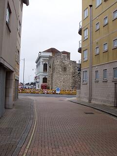
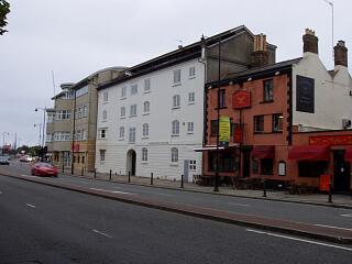
 Watergate Tower remains from Winkle Street, 30.8.09 (camera date not set), © I Peckham |  Eastgate House and other buildings, Town Quay, 30.8.09 (camera date not set), © I Peckham |
If you have any feedback or new information about this record, please email the Southampton HER (her@southampton.gov.uk).
Search results generated by the HBSMR Gateway from exeGesIS SDM Ltd.