If you have any feedback or new information about this record, please email the Southampton HER (her@southampton.gov.uk).
Data derived from Heritage Gateway will not be acceptable for any use associated with development proposals and other planning matters.
For important guidance on the use of this record, please click
here
. © Southampton City Council
| HER Number: | MSH564 |
|---|
| Type of Record: | Monument |
|---|
| Name: | Southampton Castle - Castle Garderobe Tower |
|---|
| Grid Reference: | SU 4184 1141 |
|---|
| Map: | Show location on Streetmap |
|---|
Summary
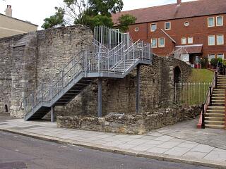
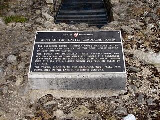
The Castle Garderobe Tower was in the south-west corner of the site of Southampton Castle. Its remains, now displayed as a monument, were uncovered during archaeological excavations in 1973/1974 and after (SOU 123 Area A and SOU 116). It was built in the 13th century against the existing south wall of Castle Hall. It was a large, tide-flushed garderobe, probably also used as a defensive tower. The tower was incorporated into the line of the western town wall in the late 14th century. The excavations showed that the west end of the structure was rectangular, although some historic maps may show it as half-round.
Protected Status
- Scheduled Monument 1001889: Castle (part of), Western Esplanade
Other References/Statuses
- HER backup file (new series): SOU 123 (digital only), etc
- National Monuments Record (ex OS Antiquity Record): SU 41 SW 4
- National Monuments Record (ex OS Antiquity Record): SU 41 SW 96
- Old Southampton SMR No/Backup file: SU 4111 SE 66 also SU 4111 SE 67
Monument Type(s):
- CASTLE (Medieval to Post Medieval - 1066 AD? to 1618 AD)
- ANGLE TOWER (Built, Medieval - 1200 AD to 1299 AD)
- GARDEROBE (Built, Medieval - 1200 AD to 1299 AD)
Full description
See Parent Record MSH23 for a summary of the documentary and excavation evidence for Southampton Castle, a discussion of the development of the Castle derived largely from [1], and a full list of sources. (References given in chronological order.)
[5] 1596/1611 map: Shows a tower apparently at the south-west corner of the castle.
[6] 1630 French map: As [5], from which it is clearly derived.
[7] c1770 plan: Very imprecise in this area.
[8] 1771 map: Shows a half-round tower apparently some way to the south-west of the castle site, but perhaps intended to be the tower adjoining the castle garderobe, which otherwise is not shown. The water is shown at the foot of the walls.
[9] 1791 map: As the 1771 map, although the tower appears to be at the south end of the castle wall.
[10][11]: Englefield 1801 & 1805: This tower is not mentioned, either on the pages describing the castle or those describing the town walls.
[12] 1846 map: Tower appears to be shown, occupied by a building.
[13] 1870 map: The remains of a tower are indicated (labelled) where the castle and town walls join, roughly where the castle garderobe is now. There is a building on the site.
[14] JS Davies 1883: "…the remains of the tower at the south-west angle of the baily." (Not described.)
[15]: VCH 1908. Description and details are all from Davies [14].
Early 20th century and post-WWII maps: “Tower (site of)” marked.
[16][17] NMR: (No 33 on [16]) Tower (at SW corner of castle, where it joins the town wall). No further details.
[18]: Pevsner - not yet checked.
SOU 123 Area A (UBS II) and part of SOU 116 (excavation and watching brief in 1973/1974 and after):
[1]: Describing the castle garderobe, at the west end of which “an opening led through the base of a mural tower.” The footings of a short length of town wall were found, adjoining this mural tower. (The garderobe, mural tower and town wall are shown on figure 9. The conjectured shape of the west end of the mural tower, outside the excavated area, is shown as round.)
[3] in [2]:
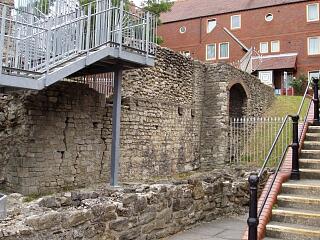
_ 13th century (Phase 2): Garderobe to the south of Castle Hall, with a latrine channel probably flushed by the tide (Garderobe 2). Described. The superstructure is largely conjectural. It was at least 2 storeys high and butted against the exterior face of the south wall of the hall. It was supported by three buttresses on its southern site (one subsequently obscured by the construction of the town wall against this building) (fig 5). At the western end of the channel was a tunnel 2.36m long, the west end of which was blocked with rubble makeup. The front face of the garderobe structure was observed during the relaying of the pavement (shown on Fig 5). Its western aspect must have given the appearance of, and it may have acted as, a corner tower. No closely datable architectural features, although the character of the masonry might suggest a 13th century date. A 13th century date may also be suggested from the documentary evidence, although not proven (see MSH23).
_ 16th to 18th century: Partial demolition, collapse, infilling and levelling of area.
(See also [4] for earlier report on this site.)
SCC HER 26/10/09: [1] conjectures that the west end of the garderobe was a half-round mural tower. Late 18th century maps show a half round tower at this location. However according to [3] the west face was exposed during observations on pavement relaying. The tower is shown with a rectangular end on fig 5 of [3]. The pavement observations may have occurred after [1] was compiled. This tower is not mentioned in the 1454 terrier, probably because it was part of the castle and therefore not the responsibility of the town.
[19][20]: Popular publications. Section on The Garderobe (photo in one).
[21]: Popular booklet, details largely from [2]. (Includes diagram showing how the tidal flushing of the garderobe would have worked).
Sources / Further Reading
| --- | SSH3068 - Unpublished document: Ancient Monument File AM17 - North-west town walls. |
| --- | SSH6080 - Unpublished document: Southampton City Council (City Architect and City Treasurer). 1980. Leisure Committee report - 2 July 1980 (etc): Castle remains, Upper Bugle Street - Public Access Layout.. |
| --- | SSH6081 - Unpublished document: ?1980. Castle Remains, Upper Bugle Street (photocopies of set of photos).. |
| --- | SSH6082 - Unpublished document: ?1980. Annotated copy of plan of Castle Remains, Upper Bugle Street excavations.. |
| [1] | SSH925 - Serial: SARC. 1974?. Southampton Archaeological Research Committee Annual Report for 1973-4. pp 13 - 17, figure 9 (p 26). |
| [2] | SSH516 - Monograph: J Oxley (ed). 1986. Excavations at Southampton Castle. Southampton Archaeological Monograph 3. incl figs 3 and 5 |
| [3] | SSH1943 - Article in monograph: DF Devereux. 1986. SOU 123 (Upper Bugle Street Phase II).. Oxley, 1986: Excavs at Soton Castle. all (pp 16 - 38, figure 1) |
| [4] | SSH1161 - Serial: M Hughes (ed), Hampshire County Council. 1981. Archaeology in Hampshire Annual Report for 1980. p 25 |
| [5] | SSH681 - Map: Speed. 1596/1611. Speed's Map of Southampton published 1596 and 1611 (black and white version). Paper. |
| [6] | SSH3198 - Map: ?. c1630. Plan of Southampton (About 1630) - From the original, attributed to a French Spy, in the British Museum.. Paper. |
| [7] | SSH2947 - Map: John Speed / Miss Ellen Stevens. c1770/1907. The Town of Southampton with its Neighbourhood / Plan of Southampton about 1770. Paper. |
| [8] | SSH921 - Map: P Mazell. 1771. A Plan of Southampton and of the Polygon 1771. Paper. |
| [9] | SSH922 - Map: T Milne (surveyor). 1791. Plan of the Town of Southampton 1791. Paper. |
| [10] | SSH944 - Bibliographic reference: Englefield. 1801. A Walk Through Southampton (First Edition). |
| [11] | SSH782 - Bibliographic reference: Englefield. 1805. A Walk Through Southampton (Second Edition). (Considerably augmented: To which is added, Some Account of the Roman Station, Clausentum.). pp 26-7, etc |
| [12] | SSH679 - Map: Campbell/Yolland/Royal Engineers. 1846. Plan of the Borough of Southampton surveyed in 1845-6.. Paper. |
| [13] | SSH977 - Map: Ordnance Survey. 1870. OS 1870 1:500 series (Sometimes referred to as the 1868 map). Paper. 1:500. |
| [14] | SSH664 - Bibliographic reference: JS Davies. 1883. A History of Southampton. p 74 |
| [15] | SSH634 - Bibliographic reference: 1908. Victoria County History Hants Volume 3 (1908). 3. p 500 |
| [16] | SSH2624 - Unpublished document: NMR/OS. 1969-1982. NMR/OS Antiquity Record SU 41 SW 4. |
| [17] | SSH2655 - Unpublished document: NMR/OS. 1969. NMR/OS Antiquity Record SU 41 SW 96. |
| [18] | SSH915 - Bibliographic reference: N Pevsner and D Lloyd. 1967. The Buildings of England - Hampshire and the Isle of Wight. |
| [19] | SSH914 - Bibliographic reference: S Pay. 1992. Walk the Southampton Walls. |
| [20] | SSH3197 - Bibliographic reference: S Jones. 2000. Walk the Southampton Walls - A DIY Guide to the Old Town. |
| [21] | SSH3196 - Bibliographic reference: J Hodgson. 1986 +. Southampton Castle. pp 20-21 |
Associated Finds: None recorded
Associated Events
- ESH123 - Excavations in Upper Bugle Street and the Southampton Castle Site in 1973/1974 (UBS II) (Ref: SOU 123)
- ESH1553 - Drawn Survey of walls at Castle Hall and Watergate Passage in 1983/1984 (Ref: SOU 116)
Related records
| MSH23 | Child of: Former Southampton Castle |
Associated Links: None recorded
Images
 Castle Hall, Castle Garderobe and remains of south town wall, Western Esplanade, 21.6.09, © I Peckham |  Castle Garderobe, Western Esplanade - plaque, 21.6.09, © I Peckham |
 South wall of Castle Hall, Castle Garderobe and remains of south town wall, from Western Esplanade, 21.6.09, © I Peckham | |
If you have any feedback or new information about this record, please email the Southampton HER (her@southampton.gov.uk).
Search results generated by the HBSMR Gateway from exeGesIS SDM Ltd.