| Name: | Medieval city wall and Red Ditch, Well Street |
|---|
| HER no.: | MCT243 |
|---|
| Type of Record: | Monument |
|---|
Summary
In the early 1960s excavations at this location found remains of the medieval city wall, thought to have been constructed here in the late 15th century. Evidence of a ditch was also found, suggesting that prior to the wall the city may have been defended by a ditch and earthwork.
| Grid Reference: | SP 3317 7930 |
|---|
| Former Parish: | Holy Trinity |
|---|
Monument Type(s):
- TOWN DITCH (Earlier Medieval to Later Medieval - 1250 AD to 1400 AD)
- TOWN DEFENCES (Earlier Medieval to Tudor - 1301 AD to 1500 AD)
- HOUSE (Later Medieval to 16th Century - 1351 AD to 1540 AD)
- TOWN WALL (Built, Later Medieval to Tudor - 1450 AD to 1500 AD (between))
Protected Status: None recorded
Full description
1,2,3> Excavation of town defences during 1960-62 by C Woodfield.
4> In 1961, Mrs C. Woodfield excavated a section of the wall in Well Street. Here, an unsuspected ditch datable to sometime after 1250, was found which could be connected with the uprising of Simon de Montfort. This was not evident in King Street but does suggest that the northern side of the city was defended, not by the River Sherbourne at this time, but by a ditch and earthwork. On both sides sporadic occupation during the 13th/14th century had given way to in the 14th/15th century to the building of the wall, which was shown to be 5ft wide on 7ft (1.5m x 2.1m) foundations. Although the ashlar faces had been robbed, the core of mortar and stone rubble survived. The wall is unlikely to have been erected in King Street until the early 15th century; while in Well Street, the late 15th century is a more likely date as it overlay a 15th century house.
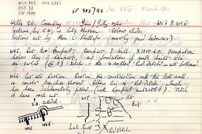
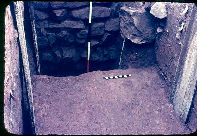
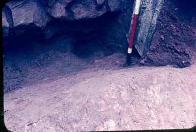
5> Sections by B.H. in City Museum. Sections cut by Miss C. Phillips. WSI cut through rampart: rampart and wall >1350 AD. Occupation below clay of rampart and foundations of wall built into an earlier (12th century?) ditch - the so-called 'Red Ditch' - not bottomed.
6> A…section at Well Street revealed an unsuspected ditch cut after 1250 (probably in the 1260s when Simon de Monfort the Younger was ravaging from Kenilworth). There had been sporadic earlier 13th century occupation on the site. The N. defence of the city was not, therefore, at this period the River Sherbourne, as had been thought. This ditch was filled in the 14th century, apparently by dismangling the bank, and a house was built over it in the late 14th or early 15th century, but destroyed after 1450 (cf. four almost complete 15th century vessels found crushed in the corner of a room), just before the wall and bank were built…
7> A third section at Well Street (fig 83) revealed an unsuspected ditch cut after 1250 (probably in the 1260s when Simon de Montfort the younger was ravaging from Kenilworth). There had been sporadic ealier 13th century occupation on the site. The N defence of the city was not, therefore, at this period the River Sherbourne, as had been thought. This ditch was filled in the 14th century, apparently by dismantling the bank, and a house was built over it in the late 14th or early 15th century, but destroyed after 1450 (cf. four almost complete 15th century vessels found crushed in the corner of a room), just before the wall and bank were built…
<1> 1987, Excavation Index, - (--MONOGRAPH). SCT720.
<2> 1960, West Midlands Archaeology, - (--ARTICLE). SCT348.
<3> 1963, Untitled Source, 81; 88-138 (--MONOGRAPH). SCT349.
<4> Coventry Museums, 1977, Coventry Archaeology & Redevelopment, p.39 (--MONOGRAPH). SCT704.
<5> Coventry Museum Archaeology Unit, 1960, Well Street Wall Excavations 1960: Site summary notes (TEXT). SCT1970.
<5> Coventry Museum Archaeology Unit, 1962, Walsgrave on Sowe Medieval Moated Site 1962: Site summary notes (TEXT). SCT1972.
<6> Historical Association, Coventry Branch, 1971, Coventry's Town Wall (-PUBLICATION). SCT1581.
Sources and Further Reading
| <1> | SCT720 --MONOGRAPH: 1987. Excavation Index. -. |
| <2> | SCT348 --ARTICLE: 1960. West Midlands Archaeology. -. |
| <3> | SCT349 --MONOGRAPH: 1963. 81; 88-138. |
| <4> | SCT704 --MONOGRAPH: Coventry Museums. 1977. Coventry Archaeology & Redevelopment. Rylatt, M.. A4 duplex. 59. p.39. |
| <5> | SCT1970 TEXT: Coventry Museum Archaeology Unit. 1960. Well Street Wall Excavations 1960: Site summary notes. |
| <5> | SCT1972 TEXT: Coventry Museum Archaeology Unit. 1962. Walsgrave on Sowe Medieval Moated Site 1962: Site summary notes. |
| <6> | SCT1581 -PUBLICATION: Historical Association, Coventry Branch. 1971. Coventry's Town Wall. Gooder, E.. A4 simplex. 24. |
Associated Finds
- FCT444 - VESSEL (Later Medieval to Tudor - 1401 AD to 1500 AD)
Associated Events
- ECT32 - City Wall Excavation, Well Street, 1962
- ECT680 - Conservation Management Plan Condition Survey for Medieval Defences
Related records
| MCT16883 | Related to: Excavation of the medieval city wall and bastion, Well Street (Monument) |
| MCT2599 | Related to: Medieval City Wall (Monument) |
Images
 Well Street Wall Excavations 1960: Site summary notes © Coventry City Council |
 Upper Well Street Excavations 1960 (WSI): 14th century wall, 'Red Ditch' and a pre-wall hut © Coventry City Council |
 Excavations at Upper Well Street 1960 (WSI): 'Red Ditch' under 14th century wall © Coventry City Council |
If you have any comments or new information about this record, please email us.
Search results generated by the HBSMR Gateway from exeGesIS SDM Ltd.